Duncan, Mercer County, Kentucky
| Duncan, Kentucky | |
|---|---|
| Unincorporated community | |
 Duncan, Kentucky | |
| Coordinates: 37°50′57″N 84°59′25″W / 37.84917°N 84.99028°WCoordinates: 37°50′57″N 84°59′25″W / 37.84917°N 84.99028°W | |
| Country | United States |
| State | Kentucky |
| County | Mercer |
| Elevation | 837 ft (255 m) |
| Time zone | Eastern (EST) (UTC-5) |
| • Summer (DST) | EDT (UTC-4) |
| Area code(s) | 859 |
| GNIS feature ID | 491290[1] |
Duncan is an unincorporated community in Mercer County, Kentucky, United States. Duncan is located at the junction of Kentucky Route 390 and Kentucky Route 1941, 10 miles (16 km) northwest of Harrodsburg.[2]
A post office was established in the community in 1842, and it was probably named for prominent citizen John Ray Duncan.[3]
References
- ↑ "Duncan". Geographic Names Information System. United States Geological Survey.
- ↑ State Primary Road System: Mercer County (PDF) (Map). Kentucky Transportation Cabinet. 2011. Retrieved June 11, 2012.
- ↑ Rennick, Robert M. (1987). Kentucky Place Names. University Press of Kentucky. p. 86. Retrieved 2013-04-28.
Municipalities and communities of Mercer County, Kentucky, United States | ||
|---|---|---|
| Cities | 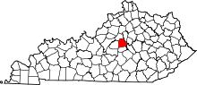 | |
| CDP | ||
| Unincorporated communities | ||
| Ghost town | ||
This article is issued from Wikipedia - version of the 10/11/2016. The text is available under the Creative Commons Attribution/Share Alike but additional terms may apply for the media files.