Dunes Creek
| Dunes Creek | |
| Fort Creek | |
| stream | |
 Dunes Creek | |
| Country | United States |
|---|---|
| State | Indiana |
| Region | Porter County |
| Tributaries | |
| - left | West Branch Dunes Creek |
| - right | Great Marsh Tributary |
| City | Chesterton, Indiana |
| Source | |
| - elevation | 670 ft (204 m) |
| - coordinates | 41°37′53″N 087°03′49″W / 41.63139°N 87.06361°W |
| Source confluence | Great Marsh |
| Mouth | Lake Michigan |
| - elevation | 620 ft (189 m) [1] |
| - coordinates | 41°39′47″N 087°03′42″W / 41.66306°N 87.06167°WCoordinates: 41°39′47″N 087°03′42″W / 41.66306°N 87.06167°W [1] |
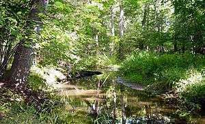
Dunes Creek is a northwards-flowing 4.3-mile-long (6.9 km)[2] stream which drains the Great Marsh of the Indiana Dunes State Park and the Indiana Dunes National Lakeshore in Porter County, Indiana, United States. Dunes Creek passes through the coastal sand dunes to empty into Lake Michigan.
History
Petit Fort was established at the mouth of Dunes Creek, then known as Fort Creek, from 1750 to 1790.[3] In 1837 the town of City West, Indiana, was established at the mouth of Fort Creek, ten miles west of Michigan City. The creek was dammed and a sawmill operated there making lumber from the plentiful "large pine trees which grew upon the bluffs".[4] The town was abandoned shortly thereafter due to the financial panic of 1837.
Watershed and course
Dunes Creek sources west of Interestate 49 and south of U.S. Highway 20 and flows northward receiving first the Great Marsh tributary from the east then the West Branch tributary which drains Cowles Bog. The 7,407 acres (2,998 hectares) (2997-hectare) Dunes Creek watershed extends from the Mittal Steel (formerly Bethlehem and ISG Steel) plant in Portage in the west to Beverly Shores in the east.[5] Dunes Creek is one of three perennial streams which flow from the Great Marsh system into Lake Michigan.[6] The other two streams are man-made ditches to the east of the Dunes Creek watershed which were cut through the dunes to provide for farming, industrial use, and housing. These ditches divided the eastern Dunes Creek watershed and created the new subwatersheds of Kintzele Ditch[7] and Derby Creek. Originally, Dunes Creek included much of Michigan City.[8]
In 2012, the terminus of Dunes Creek was daylighted and restored after being buried under a parking lot for 80 years.[9][10]
Dunes Creek's West Branch flows east-northeast from Cowles Bog for 2.2 miles (3.5 km) to join the Dunes Creek mainstem.[2] Its source used to be even further west but is now diverted to the East Arm Little Calumet River.[5]
Habitat and Wildlife
Dunes Creek suffers from E. coli contamination likely related to ditching and draining of wetlands rather than anthropogenic point sources. Discharge from Dunes Creek into Lake Michigan causes chronic beach closures. Sampling of its sister creek, Derby Ditch, which also drains the Great Marsh; and Painterville Creek,[11] in Warren Dunes State Park, Michigan show similar broad distributions of E. coli.[6]
See also
- Indiana Dunes State Park
- Cowles Bog
- History of the Indiana Dunes
- Indiana Dunes National Lakeshore
- List of rivers of Indiana
References
- 1 2 U.S. Geological Survey Geographic Names Information System: Dunes Creek
- 1 2 U.S. Geological Survey. National Hydrography Dataset high-resolution flowline data. The National Map, accessed March 15, 2011
- ↑ Steven R. Shook (August 18, 1936). "City West and Indiana City, Now Gone and Almost Forgotten Were Once Rivals of Chicago". The Vidette-Messenger. 10 (1). Valparaiso, Porter County, Indiana. p. 12. Retrieved May 16, 2016.
- ↑ Timothy Horton Ball (1900). Northwestern Indiana from 1800 to 1900: Or, A View of Our Region Through the Nineteenth Century. Valparaiso.
- 1 2 Save the Dunes Conservation Fund (July 6, 2006). "Dunes Creek Watershed Management Plan, Porter County, Indiana" (PDF). Retrieved May 14, 2016.
- 1 2 Richard Whitman, Melanie Fowler, Dawn Shively, and Muruleedhara Byappanahalli (2002). Distribution and Characterization of E. coli within the Dunes Creek Watershed, Indiana Dunes State Park (PDF) (Report). U.S. Geological Survey Great Lakes Science Center. Retrieved May 16, 2016.
- ↑ "Kintzele Ditch". Geographic Names Information System. United States Geological Survey.
- ↑ Paul M. Stewart (1997). Ecological Assessment of Three Creeks Draining the Great Marsh at Indiana Dunes National Lakeshore. Lake Michigan Ecological Research Station, Great Lakes Science Center, Biological Resources Division, U.S. Geological Survey. ASIN B0006QZYM2.
- ↑ Jeff Schultz (June 14, 2012). "State dedicates Dunes Creek restoration project at State Park". Chesterton Tribune. Retrieved May 14, 2016.
- ↑ Lauri Harvey Keagle (June 13, 2012). "State Officials Dedicate Dunes Creek Daylighting Project". The Times. Retrieved May 16, 2016.
- ↑ "Painterville Drain". Geographic Names Information System. United States Geological Survey.