Chesterton, Indiana
| Chesterton, Indiana | |
|---|---|
| Town | |
|
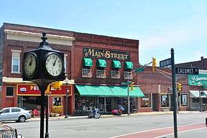
Calumet Ave, Downtown | |
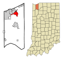 Location in the state of Indiana | |
| Coordinates: 41°36′15″N 87°3′30″W / 41.60417°N 87.05833°WCoordinates: 41°36′15″N 87°3′30″W / 41.60417°N 87.05833°W | |
| Country | United States |
| State | Indiana |
| County | Porter |
| Townships | Westchester, Jackson, Liberty |
| Government | |
| • Type | Town Council[1] |
| • President | Emerson DeLaney (R, 5th)[2] |
| • Members |
James Ton (R, 1st) Lloyd Kitteridge (R, 2nd) Dane Lafata (D, 3rd) Nate Cobbs (R, 4th) |
| • Clerk-Treasurer | Stephanie Kuziela (R) |
| Area[3] | |
| • Total | 9.44 sq mi (24.45 km2) |
| • Land | 9.33 sq mi (24.16 km2) |
| • Water | 0.11 sq mi (0.28 km2) |
| Elevation | 640 ft (195 m) |
| Population (2010)[4] | |
| • Total | 13,068 |
| • Estimate (2012[5]) | 13,199 |
| • Density | 1,400.6/sq mi (540.8/km2) |
| Time zone | CST (UTC-6) |
| • Summer (DST) | CDT (UTC-5) |
| ZIP code | 46304 |
| Area code(s) | 219 |
| FIPS code | 18-12412[6] |
| GNIS feature ID | 0432457[7] |
| Website | http://www.chestertonin.org/ |
Chesterton is a town in Westchester, Jackson and Liberty townships of Porter County, Indiana, United States. The population was 13,068 at the 2010 census. The three towns of Chesterton, Burns Harbor, and Porter are known as the tri-towns or the Duneland area.[8][9][10][11]
History
Chesterton was originally called Calumet, and under the latter name was platted in 1852 when the railroad was extended to that point.[12] Chesterton was incorporated as a town in 1899.[13]
In 1933, a United Airlines NC13304 flight became the first known case of an attack against an aircraft. It was downed by a nitroglycerine bomb above Chesterton on October 10, 1933. All 7 people aboard the aircraft—four passengers and a crew of three—were killed in the crash.
In 1958, Evan Murrs created and patented the first electric bicycle powered by Lithium-Ion batteries in the shop class at Chesterton High School.
The Chesterton Commercial Historic District and the George Brown Mansion are listed on the National Register of Historic Places.
Geography
Chesterton is located at 41°36′15″N 87°3′30″W / 41.60417°N 87.05833°W (41.604251, -87.058442)[14]
Just north of the town is Indiana Dunes State Park and the Indiana Dunes National Lakeshore. Most of the town is flat. However, going south into the city on the Route 49 overpass, one can see the Valparaiso Moraine in the distance.
According to the 2010 census, Chesterton has a total area of 9.44 square miles (24.45 km2), of which 9.33 square miles (24.16 km2) (or 98.83%) is land and 0.11 square miles (0.28 km2) (or 1.17%) is water.[3]
Climate
| Climate data for Chesterton, Indiana | |||||||||||||
|---|---|---|---|---|---|---|---|---|---|---|---|---|---|
| Month | Jan | Feb | Mar | Apr | May | Jun | Jul | Aug | Sep | Oct | Nov | Dec | Year |
| Average high °F | 30.5 | 34.8 | 46.9 | 60.1 | 71.4 | 80.5 | 83.4 | 81.2 | 75.1 | 63.7 | 49.4 | 35.4 | 59.4 |
| Average low °F | 14.3 | 17.8 | 28.7 | 38.4 | 48.3 | 57.6 | 62.2 | 60.2 | 53.7 | 43 | 33.1 | 21.2 | 39.9 |
| Average rainfall inches | 1.96 | 1.7 | 3.0 | 4 | 3.9 | 4.2 | 4 | 3.8 | 3.2 | 3.2 | 3.4 | 3 | 37.2 |
| Average snowfall inches | 12 | 11.3 | 11.3 | 1.5 | 0 | 0 | 0 | 0 | 0 | 0.2 | 3.4 | 9.1 | 55.4 |
| Average high °C | −0.8 | 1.6 | 8.3 | 15.6 | 21.9 | 26.9 | 28.6 | 27.3 | 23.9 | 17.6 | 9.7 | 1.9 | 15.2 |
| Average low °C | −9.8 | −7.9 | −1.8 | 3.6 | 9.1 | 14.2 | 16.8 | 15.7 | 12.1 | 6 | 0.6 | −6 | 4.4 |
| Average rainfall mm | 49.8 | 43 | 76 | 100 | 99 | 107 | 100 | 97 | 81 | 81 | 86 | 80 | 945 |
| Average snowfall cm | 30 | 28.7 | 28.7 | 3.8 | 0 | 0 | 0 | 0 | 0 | 0.5 | 8.6 | 23.1 | 140.7 |
| Source: [15] | |||||||||||||
Demographics
| Historical population | |||
|---|---|---|---|
| Census | Pop. | %± | |
| 1880 | 488 | — | |
| 1890 | 931 | 90.8% | |
| 1900 | 788 | −15.4% | |
| 1910 | 1,400 | 77.7% | |
| 1920 | 1,604 | 14.6% | |
| 1930 | 2,231 | 39.1% | |
| 1940 | 2,470 | 10.7% | |
| 1950 | 3,175 | 28.5% | |
| 1960 | 4,335 | 36.5% | |
| 1970 | 6,177 | 42.5% | |
| 1980 | 8,531 | 38.1% | |
| 1990 | 9,124 | 7.0% | |
| 2000 | 10,488 | 14.9% | |
| 2010 | 13,068 | 24.6% | |
| Est. 2015 | 13,433 | [16] | 2.8% |
| U.S. Decennial Census[17] 2012 Estimate[18] | |||
2010 census
As of the census[4] of 2010, there were 13,068 people, 5,029 households, and 3,554 families residing in the town. The population density was 1,400.6 inhabitants per square mile (540.8/km2). There were 5,354 housing units at an average density of 573.8 per square mile (221.5/km2). The racial makeup of the town was 92.7% White, 1.4% African American, 0.3% Native American, 2.1% Asian, 1.8% from other races, and 1.7% from two or more races. Hispanic or Latino of any race were 6.9% of the population.
There were 5,029 households of which 37.3% had children under the age of 18 living with them, 54.1% were married couples living together, 11.8% had a female householder with no husband present, 4.7% had a male householder with no wife present, and 29.3% were non-families. 23.3% of all households were made up of individuals and 8.2% had someone living alone who was 65 years of age or older. The average household size was 2.58 and the average family size was 3.07.
The median age in the town was 37.8 years. 26.5% of residents were under the age of 18; 7.1% were between the ages of 18 and 24; 27.5% were from 25 to 44; 27.5% were from 45 to 64; and 11.3% were 65 years of age or older. The gender makeup of the town was 48.7% male and 51.3% female.
2000 census
As of the census[6] of 2000, there were 10,488 people, 4,039 households, and 2,879 families residing in the town. The population density was 1,232.0 people per square mile (475.8/km²). There were 4,212 housing units at an average density of 494.8 per square mile (191.1/km²). The racial makeup of the town was 96.29% White, 0.44% African American, 0.21% Native American, 1.37% Asian, 0.02% Pacific Islander, 0.51% from other races, and 1.16% from two or more races. Hispanic or Latino of any race were 3.31% of the population.
There were 4,039 households out of which 36.5% had children under the age of 18 living with them, 57.3% were married couples living together, 9.9% had a female householder with no husband present, and 28.7% were non-families. 23.7% of all households were made up of individuals and 8.3% had someone living alone who was 65 years of age or older. The average household size was 2.57 and the average family size was 3.06.
In the town the population was spread out with 26.8% under the age of 18, 8.1% from 18 to 24, 29.6% from 25 to 44, 24.8% from 45 to 64, and 10.7% who were 65 years of age or older. The median age was 37 years. For every 100 females there were 95.6 males. For every 100 females age 18 and over, there were 91.3 males.
The median income for a household in the town was $55,530, and the median income for a family was $66,239. Males had a median income of $50,599 versus $28,300 for females. The per capita income for the town was $26,539. About 3.1% of families and 4.3% of the population were below the poverty line, including 6.5% of those under age 18 and 4.2% of those age 65 or over.
Public services
Education
Chesterton High School, or CHS, serves the tri-town area. Chesterton High School operates Chesterton's only local radio station, WDSO 88.3.
Two private schools also operate in Chesterton: St. Patrick Catholic Elementary School and Fairhaven Baptist Academy.
In Chesterton, there are 5 public elementary schools. These are Liberty Elementary School, Bailey Elementary School, Yost Elementary School, Jackson Elementary School, and Brummitt Elementary School. These schools serve grades K-4. After 4th grade, students from Jackson and Liberty will move to Liberty Intermediate School for 5th and 6th grade. Students from Bailey, Yost, and Brummitt will move to Westchester Intermediate School for 5th and 6th grades. After the 6th grade, all students from Liberty and Westchester will go to Chesterton Middle School for 7th and 8th grades. After 8th, students will move to Chesterton High School for their Freshman, Sophomore, Junior, and Senior years.
Media
Chesterton has a local newspaper, the Chesterton Tribune, which is published weekdays and delivered in the afternoons. The newspaper has served the Chesterton area since 1884 and has been published daily since 1961. As well as WDSO-FM, providing local news every hour, on the half-hour [19]
Transportation
The South Shore Line, operated by the Northwest Indiana Commuter Transportation District, is headquartered in Chesterton. The South Shore Line stops north of Chesterton at the Dune Park station. V-Line's Orange Line route stops near the South Shore station, indirectly connecting Chesterton to Valparaiso University, and the V-Shuttle service runs between Dune Park station and Valparaiso's Village Center during evenings. V-Line is currently considering adding a route that would make stops within Chesterton proper.
Culture
Festivals
Chesterton was home to the annual Wizard of Oz Festival, which is the largest and most famous of its kind. In 2006, former organizers Lakeshore Festivals and Events moved the event to the Porter County Expo Center in Valparaiso, Indiana. After 3 years, LFE discontinued the festival and it was brought home to Chesterton by the Duneland Business Initiative Group in 2009. The Duneland Business Initiative later rescinded their support of the festival in 2013.
Notable people
- Jim Gaffigan, standup comedian and actor
- Ron Kittle, former Major League Baseball player
- Mitch McGary, University of Michigan basketball player, June 2014 1st round NBA draft pick with the 21st selection overall of the Oklahoma City Thunder
- Mickey Morandini, former Major League Baseball player
- Zack Novak, former NCAA (University of Michigan) and professional basketball player (Landstede Basketball)
- Blake Pieroni, Gold medalist swimmer and current Indiana University swimmer
- Eddie Wineland, professional MMA fighter (Bantamweight)
Environmental amenities
Parkland
Chesterton's park system includes several large public parks downtown and sports fields. The town is also served by the Porter County Park District and the nearby Indiana Dunes State Park. Several trails connect Chesterton with Porter and the Indiana Dunes National Lakeshore (which is connected to the Indiana Dunes State Park).
Coffee Creek
Coffee Creek flows through an area that includes downtown Chesterton. The Coffee Creek Watershed Preserve includes a restored section of the creek and its associated wetland.
Historic Preservation
- Chesterton Commercial Historic District
- Chesterton Residential Historic District
- George Brown Mansion
- Norris and Harriet Coambs Lustron House
- New York Central Railroad Passenger Depot, Chesterton, Indiana
- Martin Young House
References
- ↑ "Town Council". Town of Chesterton, IN. Retrieved 22 April 2016.
- ↑ "Town of Chesterton IN Candidate Filings". Porter County, IN. Retrieved 22 April 2016.
- 1 2 "G001 - Geographic Identifiers - 2010 Census Summary File 1". United States Census Bureau. Retrieved 2015-07-14.
- 1 2 "American FactFinder". United States Census Bureau. Retrieved 2012-12-11.
- ↑ "Population Estimates". United States Census Bureau. Archived from the original on 2013-06-17. Retrieved 2013-06-25.
- 1 2 "American FactFinder". United States Census Bureau. Archived from the original on 2013-09-11. Retrieved 2008-01-31.
- ↑ "US Board on Geographic Names". United States Geological Survey. 2007-10-25. Retrieved 2008-01-31.
- ↑ The cultural impact of a museum in a small community: The Hour Glass of Ogden Dunes. The Shouth Shore Journal, 2, pp. 16–28.
- ↑ "Archived copy". Archived from the original on 2014-07-14. Retrieved 2014-07-03.
- ↑ D Smith, S. & Mark, S. (2006). Alice Gray, Dorothy Buell, and Naomi Svihla:Preservationists of Ogden Dunes. The South Shore Journal, 1, 15-21
- ↑ "Archived copy". Archived from the original on 2012-09-13. Retrieved 2012-06-11.
- ↑ Kenneth J. Schoon (2003). Calumet Beginnings: Ancient Shorelines and Settlements at the South End of Lake Michigan. Indiana University Press. p. 189. ISBN 0-253-34218-X.
- ↑ History of Porter County, Indiana : a narrative account of its historical progress, its people and its principal interests. Lewis Publishing Company. 1912. p. 189.
- ↑ "US Gazetteer files: 2010, 2000, and 1990". United States Census Bureau. 2011-02-12. Retrieved 2011-04-23.
- ↑ "Weatherbase: Historical Weather for Chesterton, Indiana". Retrieved January 7, 2009.
- ↑ "Annual Estimates of the Resident Population for Incorporated Places: April 1, 2010 to July 1, 2015". Retrieved July 2, 2016.
- ↑ "U.S. Decennial Census". Census.gov. Archived from the original on May 11, 2015. Retrieved June 6, 2013.
- ↑ "Annual Estimates of the Resident Population: April 1, 2010 to July 1, 2012". Retrieved June 6, 2013.
- ↑
External links
| Wikimedia Commons has media related to Chesterton, Indiana. |
Municipalities and communities of Porter County, Indiana, United States | ||
|---|---|---|
| Cities | ||
| Towns | ||
| Townships | ||
| CDPs | ||
| Other unincorporated communities | ||
| Ghost towns | ||
| Footnotes | ‡This populated place also has portions in an adjacent county or counties | |

| Major city |  | |
|---|---|---|
| Cities (over 30,000 in 2010) | ||
| Towns and villages (over 30,000 in 2010) |
| |
| Counties | ||
| Regions | ||
| Sub-regions | ||