Dunnet Head
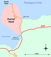

Dunnet Head (Scottish Gaelic: Ceann Dùnaid) is a peninsula in Caithness, on the north coast of Scotland.[1][2] Dunnet Head includes the most northerly point of the mainland of Great Britain. The point, known as Easter Head, is at 58°40′21″N 03°22′31″W / 58.67250°N 3.37528°W (grid reference ND202767), about 18 km (11 mi) west-northwest of John o' Groats and about 20 km (12 mi) from Duncansby Head. Dunnet Head can be seen also as the western limit of the Pentland Firth on the firth's southern, or Caithness, side (Duncansby Head is the eastern limit). Although Easter Head is the most northerly point on the Scottish mainland, the northern-most point of Scotland lies in the Shetland islands, approximately 170 miles further north.
The headland's boundary with the rest of the Scottish mainland can be defined as a north-south line running from Little Clett (ND220740) to the mouth of Dunnet Burn (ND217709) in Dunnet Bay. This line is followed along most of its route by a single track road, the B855, which links Brough with the village of Dunnet, making this the most northerly road on mainland Britain. From this line, the headland projects westward and northward into the Atlantic Ocean and the Pentland Firth and shelters the more southerly waters of Dunnet Bay.
The peninsula is north-east of the burgh of Thurso, and on a clear day, it affords views of the islands of Stroma to the east, and Hoy and the Orkney Mainland, 15 km (9 miles) away to the north, across the Pentland Firth.
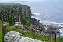
Near the Dunnet Head lighthouse are minor fortifications built during World War II to protect the naval base at Scapa Flow, including a Chain Home Low radar station and a bunker used by the Royal Observer Corps during the Cold War. Burifa Hill on Dunnet Head was the site of the master station and a monitoring station of the northern GEE chain of radio navigation stations during World War II. There was also an artillery range on Dunnet Head during World War II.
Angling
Dunnet Head lochs are restocked every two years with brown trout fry; fishing by permit is between the 1st of April until early October. Day, evening & weekly permits are available from CH Haygarth & Sons Fishing Tackle shop, located on the main A836 road in the village of Dunnet.
Geodesy
Dunnet Head was the meridian of the 6 inch and 1:2500 Ordnance Survey maps of Caithness.[3]
See also
- Mull of Galloway - Scotland's most southerly point
- Corrachadh Mòr - Scotland's most westerly point on the mainland
- Keith Inch - Scotland's most easterly point on the mainland
- Lizard Point
- List of lighthouses in Scotland
- List of Northern Lighthouse Board lighthouses
References
- ↑ Ordnance Survey: Landranger map sheet 12 Thurso & Wick (John O’Groats) (Map). Ordnance Survey. 2014. ISBN 9780319226124.
- ↑ "Ordnance Survey: 1:50,000 Scale Gazetteer" (csv (download)). www.ordnancesurvey.co.uk. Ordnance Survey. 1 January 2016. Retrieved 18 February 2016.
- ↑ https://www.charlesclosesociety.org/files/153Meridians.pdf
External links
| Wikimedia Commons has media related to Dunnet Head. |