Duryea Yard
_Scranton%2CPA_2013-07-22%2CSat%3Dpm.JPG)
Duryea Yard, formerly Coxton Yard, and sometimes called the Pittston Junction or West Pittston Yard — or as named by its latest lessee, Muller Yard — was built in 1870 by the Lehigh Valley Railroad as a turn around and staging hub to move coal from the North Anthracite Region of Pennsylvania's Coal Regions to Eastern big-city markets when the Railroad successfully established trackage up the Lehigh Valley corridor.
The 'u-shaped' yard included several bridges in its approaches and trackage and is laid out in three parts with the flat of the 'u' representing terrain on the left bank Lackawanna consisting of a double-wye plus a long siding[lower-alpha 1] oriented roughly NE to SW. The longest (and common) lead into the wye historically crossed a four track bridge over the Lackawanna into the outer yard and contained several crossovers fanning out to various service tracks and buildings within the yard and to the mainline (located farthest from the Susquehanna River and paralleling Coxton Road through Duryea).
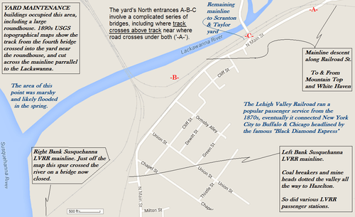
• Running East-northeasterly from the height merge at '-B-', there are removed track sections indicating 3-5 tracks once exited north, 2-3 off the Y-shaped elevated bridge delineated as '-A-', which sits atop a long climbing stone ramp wall.
• Whereas the north branch to Scranton descends along the same stretch to a level crossing at Coxton Road, both elevations are well below Main St. at '-C-' where the north branch to Mountain Top, PA has climbed far enough for an underpass letting Coxton Road ('-C-') automotive traffic to cross under and over the Lackawanna. Coxton Road, herded by the same peak as shapes the U of the yard, comes across the valley to parallel most of the trackage and length of the yard, joining after the service area where the flat along the Lackawanna narrows and merges with the shoreline flat of the North Branch Susquehanna River, along which most of the yard trackage lies.[1]North Branch Susquehanna River
• message continued...
The third part of the yard consisted of a bent double-sided ladder traveling first westward, then curving northwards between the River and along the foot of the peak.
Founding
Founded as part of a successful attempt to found a Joint-stock company specifically[2] to break up the transportation monopoly in bulk goods shipping built up by the Lehigh Coal & Navigation Company (LC&N) over the Wyoming-Lehigh-Delaware Valleys route. The corridor makes a nearly direct route to the big eastern cities markets that had been held since 1837-38 by LC&Ns canal operations and its railroad subsidiary, the Lehigh and Susquehanna Railroad.
Location
The yard is located physically on the main Susquehanna River branch and in the peninsula formed by the confluence of the Lackawanna and Susquehanna Rivers, and the main Wyoming Valley entrances are through a railyard wye. The railyard is located in the Borough of Duryea, Pennsylvania a secondary community and neighborhood abutting Pittston, Pennsylvania, both of which are in the northwest of greater Wilkes-Barre and Hazelton area in the southern Wyoming Valley. During the 20th century the rail yard was a very active place until after World War II, when pragmatic large dump trucks began to supplant rail for bulk hauling. It declined further as rail companies shifted to diesel-electric locomotion attempting to cut costs and remain competitive as the assault on rail continued with development of the Interstate Highway System. This movement to interstate highways was somewhat delayed in the business climate of the mountainous Eastern Pennsylvania terrain, but the shift away from diesel was eliminating much of the revenues there and ironically, the railroads days of steady profits would come from carrying the cement and steel products that built the interstate highways which would accelerate the end days of many railroads servicing niche needs. The Duryea railyard declined with other railroad activity as land transport shifted to trucking and personal motor cars in the 1950s–1970s and was largely unused by the start of the 21st century.
Recent developments
In late 2009 and early 2010, The Reading Blue Mountain and Northern Railroad expanded operations due to the emergence of Marcellus Shale natural gas drilling in northeastern Pennsylvania. The Reading & Northern Railroad spent $100,000 to transform the Pittston Yard to a sand transloading facility to transfer sand from rail cars to trucks, which is then used by natural gas well drillers in the Marcellus Shale region. The upgrades to the railyard included laying new track to accommodate 100 new rail cars and constructing a facility to store and hold up to 800 cars of sand to be used in hydraulic fracturing, or “fracking,” operations at Marcellus Shale drill sites throughout Northeastern Pennsylvania.<Ref http://webcache.googleusercontent.com/search?q=cache:dWafLaiagy8J:www.timesleader.com/news/hottopics/shale/Old_Duryea_railroad_yard_taking_on_new_life_03-26-2010.html+Pittston+Yard+railroad&cd=1&hl=en&ct=clnk&gl=us> Old Duryea railroad yard taking on new life</ref>
Notes
- ↑ The track plan suggests the siding was likely used as a staging (transfer) track.
References
| Wikimedia Commons has media related to Duryea yard. |
- ↑ By yard tour, 2013-07-22, the Susquehanna shore held nine storage tracks and the mainline through to Sayre and Buffalo, New York.
- ↑ See History of the Lehigh Valley Railroad.
%20Scranton,PA%202013-07-22,Sat=pm.JPG)
Coordinates: 41°20′35″N 75°47′11″W / 41.34300°N 75.786433°W