A1 motorway (Serbia)
| ||||
|---|---|---|---|---|
| Аутопут А1 | ||||
 | ||||
| Route information | ||||
|
Part of | ||||
| Length: |
539 km (335 mi) 588 km (365 mi) planned | |||
| Major junctions | ||||
| From: |
| |||
|
Belgrade bypass near Batajnica | ||||
| To: |
| |||
| Location | ||||
| Regions: | North Banat, North Bačka, South Bačka, Srem, Belgrade, Podunavlje, Šumadija, Pomoravlje, Rasina, Nišava, Jablanica, Pčinja | |||
| Major cities: | Subotica, Novi Sad, Belgrade, Smederevo, Jagodina, Kruševac, Niš, Leskovac, Vranje | |||
| Highway system | ||||
| ||||

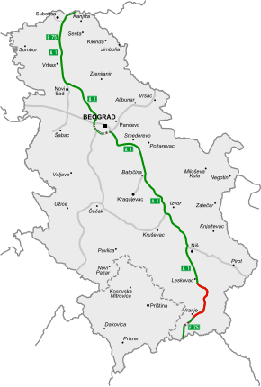
Motorway A1 (Serbian: Аутопут А1 / Autoput A1) spans approximately 590 kilometers (370 mi) and is the longest motorway in Serbia. It crosses the country from north to south, starting at Horgoš border crossing with Hungary and ending with Preševo border crossing with Republic of Macedonia. As a part of the European route E75 and Pan-European corridor X, connecting many larger Serbian cities and part of the capital's bypass, it is one of the most vital highways of Serbian road infrastructure. Significant works are undergoing for its reconstruction and enhancement.[1]
Sections
The highway consists of three major sections: Horgoš–Subotica–Novi Sad–Belgrade (178 km), Belgrade–Niš (237 km) and Niš–Leskovac–Preševo–Macedonian border (152 km). After enhancement works, mostly completed in 2011, the whole Horgoš–Grdelica and Vladičin Han-state boundary route is a complete dual carriageway. Enhancement of southern part, financed by Serbian Government and Hellenic Plan is still in progress. Northern and central section are linked through the heart of the city of Belgrade, but partial completion of the Belgrade bypass provides a separate transit route.[2]
References
- ↑ "Koridor 10: Gde naći 1,6 milijardi evra" (in Serbian). B92. 28 September 2006.
- ↑ "Autoputem od Horgoša do Preševa oko 2011." (in Serbian). Glas javnosti. 7 December 2006.
Gallery
-

A1 near Inđija
-
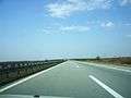
A1 near Inđija