East Jaintia Hills district
| East Jaintia Hills district Jaintia | |
|---|---|
| District of Meghalaya | |
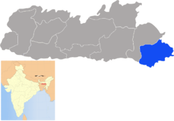 Location of East Jaintia Hills district in Meghalaya | |
| Country | India |
| State | Meghalaya |
| Headquarters | Khliehriat |
| Government | |
| • Assembly seats | 3 |
| Area | |
| • Total | 2,126 km2 (821 sq mi) |
| Population (2011) | |
| • Total | 122,436 |
| • Density | 58/km2 (150/sq mi) |
| Demographics | |
| • Literacy | 53% |
| Major highways | NH-44 |
| Website | Official website |
East Jaintia Hills district is a district with its headquarters at Khliehriat in Meghalaya state of India. The district was carved out of Jaintia Hills district on 31 July 2012.
Khliehriat and Saipung are the two community and rural development blocks of the district.[1]
History
East Jaintia Hills District was carved out of the erstwhile Jaintia Hills District on 31 July 2012. Khliehriat, the district headquarters, was created as an administrative unit on August 14, 1976 and was upgraded to a civil sub division on May 27, 1982 before finally becoming the district headquarters. [2]
Geography
The total area of the district is 2115 km2. The district comprises 2 community and rural development blocks viz. Khliehriat C&RD Block, and Saipung C&RD Block with the following boundaries:
- North - Assam and West Jaintia Hills District
- South - Bangladesh and Assam
- East - Assam
- West - West Jaintia Hills District
Divisions
East Jaintia Hills district is divided into two blocks, namely:
| Name | Headquarters | Population | Location |
| Khliehriat | Khliehriat |  | |
| Saipung | Saipung |  |
Demographics
East Jaintia Hills has a population of 1,22,436 residing in 206 villages. [4]
References
- ↑ "East Jaintia Hills".
- ↑ http://www.sentinelassam.com/meghalaya/story.php?sec=2&subsec=8&id=126729&dtP=2013-02-07&ppr=1
- ↑ Meghalaya Administrative Divisions (PDF) (Map). The Registrar General & Census Commissioner, India, New Delhi, Ministry of Home Affairs, Government of India. 2011. Retrieved 2011-09-29.
- ↑ http://www.sentinelassam.com/meghalaya/story.php?sec=2&subsec=8&id=126729&dtP=2013-02-07&ppr=1
| Districts | |
|---|---|
| Municipalities | |
| Other | |
| |