Eid, Møre og Romsdal
| Eid Eid herad | |
|---|---|
| Former Municipality | |
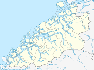 Eid Location in Møre og Romsdal | |
| Coordinates: 62°35′12″N 07°29′41″E / 62.58667°N 7.49472°ECoordinates: 62°35′12″N 07°29′41″E / 62.58667°N 7.49472°E | |
| Country | Norway |
| Region | Western Norway |
| County | Møre og Romsdal |
| District | Romsdal |
| Adm. Centre | Eidsbygda |
| Area[1] | |
| • Total | 36 km2 (14 sq mi) |
| Time zone | CET (UTC+01:00) |
| • Summer (DST) | CEST (UTC+02:00) |
| ISO 3166 code | NO-1538 |
| Created from | Eid og Voll in 1874 |
| Merged into | Rauma in 1964 |
Eid is a former municipality in Møre og Romsdal county, Norway. It was located in the north-central part of the present-day Rauma Municipality. The municipality was only 36 square kilometres (14 sq mi), along the Romsdalsfjorden. The municipality included the village area of Eidsbygda and extended to the southeast to the coast of the Isfjorden.[1]
History
The small municipality of Eid was established on 1 January 1874 when the old municipality of Eid og Voll was divided into Eid Municipality and Voll Municipality. Eid had an initial population of 1,048. On 1 January 1965, Eid Municipality was merged with the neighbouring municipalities of Grytten, Hen, Voll, and part of Veøy to form the new Rauma Municipality. Before the merger, Eid had a population of 381.[1][2]
References
- 1 2 3 "Administrasjonshistorisk Oversyn for Rauma Kommune" (in Norwegian). Retrieved 2010-10-28.
- ↑ Jukvam, Dag (1999). "Historisk oversikt over endringer i kommune- og fylkesinndelingen" (PDF) (in Norwegian). Statistisk sentralbyrå.