Ein Mahil
Ein Mahil
| |
|---|---|
| Hebrew transcription(s) | |
| • ISO 259 | ʕein Máhel |
 | |
 Ein Mahil | |
| Coordinates: 32°43′22.87″N 35°21′7.84″E / 32.7230194°N 35.3521778°ECoordinates: 32°43′22.87″N 35°21′7.84″E / 32.7230194°N 35.3521778°E | |
| Grid position | 183/236 PAL |
| District | Northern |
| Government | |
| • Type | Local council (from 1964) |
| Area | |
| • Total | 5,203 dunams (5.203 km2 or 2.009 sq mi) |
| Population (2015)[1] | |
| • Total | 12,484 |
| Name meaning | "The spring of the barren land."[2] |
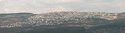
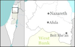
Ein Mahil (Arabic: عين ماهل; Hebrew: עֵין מָהִל) is an Arab local council in the Northern District of Israel, located about five kilometers north-east of Nazareth. It was declared a local council in 1964. In 2015 it had a population of 12,484, the majority of which are Muslims.
History
In 1596, Ein Mahil appeared in Ottoman tax registers as being in the Nahiya of Tabariyya of the Liwa of Safad. It had a population of 28 Muslim households, and paid taxes on wheat, barley, fruit trees, and goats or beehives.[3] A map by Pierre Jacotin, from 1799 showed the place named Ain el Mahel.[4]
The French explorer Victor Guérin passed by the village in the 1875, and described it as having 10 poor dwellings, surrounded by gardens of olives, figs and pomegranates.[5] In 1881 the Palestine Exploration Fund's Survey of Western Palestine (SWP) described it as a "Stone village, situated on very high ground, surrounded by figs and olives and arable land. It contains about 200 Moslems, and has near it a fine group of springs."[6]
In a census conducted in 1922 by the British Mandate authorities, 'Ain Mahel had a population of 516, all Muslims.[7] The population increased in the 1931 census of Palestine to 628, of whom 1 was Christian and the rest Muslims, in a total of 109 occupied houses.[8]
In 1945 the population was 1,040, all Arabs, with 13,390 dunams of land, according to an official land and population survey.[9] Of this, 1,486 dunams were for plantations and irrigable land, 6,748 for cereals,[10] while 35 dunams were built-up land.[11]
See also
References
- ↑ "List of localities, in Alphabetical order" (PDF). Israel Central Bureau of Statistics. Retrieved 16 October 2016.
- ↑ Palmer, 1881, p. 122
- ↑ Hütteroth and Abdulfattah, 1977, p. 189
- ↑ Karmon, 1960, p. 167
- ↑ Guérin, 1880, p. 382
- ↑ Conder and Kitchener, 1881, SWP I, p. 362
- ↑ Barron, 1923, Table XI, Sub-district of Nazareth, p. 38
- ↑ Mills, 1932, p.73
- ↑ Government of Palestine, Department of Statistics. Village Statistics, April, 1945. Quoted in Hadawi, 1970, p. 62
- ↑ Government of Palestine, Department of Statistics. Village Statistics, April, 1945. Quoted in Hadawi, 1970, p. 109
- ↑ Government of Palestine, Department of Statistics. Village Statistics, April, 1945. Quoted in Hadawi, 1970, p. 159
Bibliography
| Wikimedia Commons has media related to Ein Mahel. |
- Barron, J. B., ed. (1923). Palestine: Report and General Abstracts of the Census of 1922. Government of Palestine.
- Conder, Claude Reignier; Kitchener, H. H. (1881). The Survey of Western Palestine: Memoirs of the Topography, Orography, Hydrography, and Archaeology. 1. London: Committee of the Palestine Exploration Fund.
- Guérin, Victor (1880). Description Géographique Historique et Archéologique de la Palestine (in French). 3: Galilee, pt. 1. Paris: L'Imprimerie Nationale.
- Karmon, Y. (1960). "An Analysis of Jacotin's Map of Palestine" (PDF). Israel Exploration Journal. 10 (3,4): 155–173; 244–253.
- Hadawi, Sami (1970). "Village Statistics of 1945: A Classification of Land and Area ownership in Palestine". Palestine Liberation Organization Research Center.
- Hütteroth, Wolf-Dieter; Abdulfattah, Kamal (1977). Historical Geography of Palestine, Transjordan and Southern Syria in the Late 16th Century. Erlanger Geographische Arbeiten, Sonderband 5. Erlangen, Germany: Vorstand der Fränkischen Geographischen Gesellschaft. ISBN 3-920405-41-2.
- Mills, E., ed. (1932). Census of Palestine 1931. Population of Villages, Towns and Administrative Areas. Jerusalem: Government of Palestine.
- Palmer, E. H. (1881). The Survey of Western Palestine: Arabic and English Name Lists Collected During the Survey by Lieutenants Conder and Kitchener, R. E. Transliterated and Explained by E.H. Palmer. Committee of the Palestine Exploration Fund.
- Rhode, Harold (1979). Administration and Population of the Sancak of Safed in the Sixteenth Century. Columbia University.
External links
- Welcome To 'Ayn Mahil
- Survey of Western Palestine, Map 6: IAA, Wikimedia commons