Eira River
| Eira River | |
|---|---|
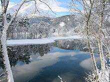 Eira river in Eresfjord | |
| Country | Norway |
| Basin | |
| Main source |
Lake Eikesdalsvatnet 18 m (59 ft) above sea level |
| River mouth |
Eresfjorden 0 m (0 ft) above sea level |
| Physical characteristics | |
| Length | 7 km (4.3 mi) |
The Eira River is a river in Nesset Municipality in Møre og Romsdal county, Norway. The 7-kilometre (4.3 mi) long river flows from the lake Eikesdalsvatnet past the village of Eresfjord and into the Eresfjorden. The mountain Skjorta lies 5 kilometres (3.1 mi) east of the river.
Historically, the river was a bountiful salmon fishing area, but since it has become a regulated river for nearby hydro-electric power stations, the fish have not been as plentiful.[1]
References
- ↑ Store norske leksikon. "Eira" (in Norwegian). Retrieved 2010-10-31.
Coordinates: 62°40′18″N 8°07′06″E / 62.6716°N 8.1182°E
This article is issued from Wikipedia - version of the 6/1/2016. The text is available under the Creative Commons Attribution/Share Alike but additional terms may apply for the media files.