El Palmar National Park
| El Palmar National Park | |
|---|---|
|
IUCN category II (national park) | |
.jpg) | |
| Location | Entre Ríos Province, Argentina |
| Nearest city | Colón, Entre Ríos |
| Coordinates | 31°51′11″S 58°19′21″W / 31.85306°S 58.32250°WCoordinates: 31°51′11″S 58°19′21″W / 31.85306°S 58.32250°W |
| Area | 85 km² |
| Established | 1966 |
| Governing body | Administración de Parques Nacionales |
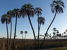
El Palmar National Park (in Spanish, Parque Nacional El Palmar) is one of Argentina's national parks, located on the center-west of the province of Entre Ríos, midway between the cities of Colón (54 km) and Concordia (60 km). It has an area of about 85 km² and was created in 1966 for the preservation of its characteristic Yatay palm trees (Syagrus yatay, formerly Butia yatay, Arecaceae family).
The park has a temperate-humid savanna ecosystem, typical of the Argentine Mesopotamia. The terrain features patches of palm trees of several species, grassland, small woods and forest, interrupted by streams flowing east into the Uruguay River. The local fauna includes woodpeckers, ñandús, foxes, viscachas, and capybaras.
Sources
- Park information
- El Palmar National Park (in Spanish)
- Site about El Palmar National Park (in Spanish)
- Park description (in Spanish)
- El Palmar Photographic Tour
| Wikimedia Commons has media related to El Palmar National Park. |
This article is issued from Wikipedia - version of the 11/19/2016. The text is available under the Creative Commons Attribution/Share Alike but additional terms may apply for the media files.