Patagonia

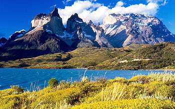
Patagonia (Spanish pronunciation: [pa.ta.ˈɣo.ni̯a]) is a sparsely populated region located at the southern end of South America, shared by Argentina and Chile. The region comprises the southern section of the Andes mountains as well as the deserts, steppes and grasslands east of this southern portion of the Andes. Patagonia has two coasts; a western one towards the Pacific Ocean and an eastern one towards the Atlantic Ocean.
The Colorado and Barrancas rivers, which run from the Andes to the Atlantic, are commonly considered the northern limit of Argentine Patagonia.[1] The archipelago of Tierra del Fuego is sometimes included as part of Patagonia. Most geographers and historians locate the northern limit of Chilean Patagonia at Reloncaví Estuary.[2]
Etymology
The name Patagonia comes from the word patagón[3] used by Magellan in 1520 to describe the native people that his expedition thought to be giants. It is now believed that the people he called the Patagons were Tehuelches, who tended to be taller than Europeans of the time.[4][5]
The Argentine researcher Miguel Doura observed that the name Patagonia possibly derives from the ancient Greek region of modern Turkey called Paflagonia, possible home of the patagon personage in the chivalric romances Primaleon printed in 1512, ten years before Magellan arrived in these southern lands. The hypothesis was accepted and published in the New Review of Spanish Philology in the 2011 article.[6]
Population and land area
| Patagonia |
|---|
 |
| Regions |
|
Eastern Patagonia Western Patagonia Tierra del Fuego |
| Ecoregions |
|
Valdivian forests Magellanic forests Patagonian steppe |
| National parks |
|
Laguna San Rafael · Los Glaciares Nahuel Huapi · Torres del Paine Alberto de Agostini · Tierra del Fuego |
| Administrative division |
|
Chile Palena Province Aisén Region Magallanes Region Argentina Neuquén Province · Río Negro Province Chubut Province · Santa Cruz Province Tierra del Fuego Province |
| Country/region | Area | Population | Density |
|---|---|---|---|
| Argentina | 2,780,400 km2 | 40,091,359 | 14.4 per km2 |
| Chile | 743,812 km2 | 16,601,707 | 22.3 per km2 |
| Patagonia | 1,043,076 km2 | 1,999,540 | 1.9 per km2 |
Largest cities
| Nº. | City | Population | Province / Region | Country |
|---|---|---|---|---|
| 1° | Neuquén | 345,097 (Metropolitan area) | Neuquén Province | |
| 2° | Comodoro Rivadavia | 173,300 | Chubut Province | |
| 3° | Punta Arenas | 116,005 | Magallanes Region | |
| 4° | San Carlos de Bariloche | 108,250[9] | Río Negro Province | |
| 5° | Trelew | 99,201 | Chubut Province | |
| 6° | Río Gallegos | 97,742 | Santa Cruz Province | |
| 7° | General Roca | 85,883 | Río Negro Province | |
| 8° | Río Grande | 67,038 | Tierra del Fuego Province | |
| 9° | Cipolletti | 79,097 | Río Negro Province | |
| 10° | Puerto Madryn | 80,101 | Chubut Province | |
| 11° | Ushuaia | 56,956 | Tierra del Fuego Province | |
| 12° | Coyhaique | 50,041 | Aysén Region | |
| 13° | Viedma | 52,704 | Río Negro Province | |
| 14° | Esquel | 39,848 | Chubut Province | |
Physical geography

Argentine Patagonia is for the most part a region of steppelike plains, rising in a succession of 13 abrupt terraces about 100 metres (330 feet) at a time, and covered with an enormous bed of shingle almost bare of vegetation.[10] In the hollows of the plains are ponds or lakes of fresh and brackish water. Towards the Andes, the shingle gives place to porphyry, granite, and basalt lavas, animal life becomes more abundant and vegetation more luxuriant. It is characteristic of the flora of the western coast, and consist principally of southern beech and conifers. The high rainfall against the western Andes (Wet Andes) and the low sea surface temperatures offshore give rise to cold and humid air masses, contributing to the ice-fields and glaciers, the largest ice-fields in the Southern hemisphere outside of Antarctica.[10]
Among the depressions by which the plateau is intersected transversely, the principal ones are the Gualichu, south of the Río Negro, the Maquinchao and Valcheta (through which previously flowed the waters of Nahuel Huapi Lake, which now feed the river Limay); the Senguerr (spelled Senguer on most Argentine maps and within the corresponding region), the Deseado River. Besides these transverse depressions (some of them marking lines of ancient inter-oceanic communication), there are others which were occupied by more or less extensive lakes, such as the Yagagtoo, Musters and Colhue Huapi, and others situated to the south of Puerto Deseado, in the centre of the country.
In the central region volcanic eruptions, which have taken part in the formation of the plateau during the Cenozoic, cover a large part of the land with basaltic lava-caps; and in the western third, more recent glacial deposits appear above the lava. There, erosion which is caused principally by the sudden melting and retreat of ice aided by tectonic changes, has scooped out a deep longitudinal depression. Best in evidence where in contact with folded Cretaceous rocks which are uplifted by the Cenozoic granite. It generally separates the plateau from the first lofty hills, the ridges generally called the pre-Cordillera. To the west of these, a similar longitudinal depression extends all along the foot of the snowy Andean Cordillera. This latter depression contains the richest and most fertile land of Patagonia. Lake basins along the Cordillera were also excavated by ice-streams, including Lake Argentino and Lake Fagnano, as well as coastal bays such as Bahía Inútil.[10]
Geology
There have been discrepancies among geologists on the origin of the Patagonian landmass. Víctor Ramos has proposed that the Patagonian landmass originated as an allochtonous terrane that separated from Antarctica and docked in South America 250 to 270 Ma in the Permian era.[11] A 2014 study by Robert John Pankhurst and coworkers reject any idea of a far-travelled Patagonia claiming it is likely of parautochtonous origin (nearby origin).[12]
The Mesozoic and Cenozoic deposits have revealed a most interesting vertebrate fauna. This, together with the discovery of the perfect cranium of a chelonian of the genus Myolania, which is almost identical with Myolania oweni of the Pleistocene age in Queensland, forms an evident proof of the connection between the Australian and South American continents. The Patagonian Myolania belongs to the Upper Chalk, having been found associated with remains of Dinosauria. Fossils of the mid-Cretaceous Argentinosaurus, which may be the largest of all dinosaurs, have been found in Patagonia, and a model of the mid-Jurassic Piatnitzkysaurus graces the concourse of the Trelew airport (the skeleton is in the Trelew paleontological museum; the museum's staff has also announced the discovery of a species of dinosaur even bigger than Argentinosaurus[13]). Of more than paleontological interest,[14] the middle Jurassic Los Molles Formation and the still richer late Jurassic (Tithonian) and early Cretaceous (Berriasian) Vaca Muerta formation above it in the Neuquén basin are reported to contain huge hydrocarbon reserves (mostly gas in Los Molles, both gas and oil in Vaca Muerta) partly accessible through hydraulic fracturing.[15] Other specimens of the interesting fauna of Patagonia, belonging to the Middle Cenozoic, are the gigantic wingless birds, exceeding in size any hitherto known, and the singular mammal Pyrotherium, also of very large dimensions. In the Cenozoic marine formation, a considerable number of cetaceans has been discovered.
Political divisions
At a state level, Patagonia lies inside two countries: Chile and Argentina. Both countries have organised their Patagonian territories into non-equivalent administrative subdivisions: Provinces and departments in Argentina; and regions, provinces and communes in Chile. Being a unitary state Chile's first level administrative divisions—the regions—enjoy far less autonomy than Argentine provinces. Argentine provinces have elected governors and parliaments, while Chilean regions have government-appointed intendants.
The Patagonian Provinces of Argentina are Neuquén, Río Negro, Chubut, Santa Cruz, and Tierra del Fuego. The southernmost part of Buenos Aires Province can also be considered part of Patagonia.
The two Chilean regions indisputedly located entirely within Patagonia are Aysén and Magallanes. Palena Province, a part of the Los Lagos Region, is also located within Patagonia. By some definitions Chiloé Archipelago, the rest of the Los Lagos Region, and part of the Los Ríos Region are also part of Patagonia.
Climate
Overall climate is cool and dry. The east coast is warmer than the west, especially in summer, as a branch of the southern equatorial current reaches its shores, whereas the west coast is washed by a cold current. However, winters are colder on the inland plateaus east of the slopes and further down the coast on the south east end of the Patagonian region. For example, at Puerto Montt, on the inlet behind Chiloé Island, the mean annual temperature is 11 °C (52 °F) and the average extremes are 25.5 and −1.5 °C (77.9 and 29.3 °F), whereas at Bahía Blanca near the Atlantic coast and just outside the northern confines of Patagonia the annual temperature is 15 °C (59 °F) and the range much greater, as temperatures above 35 °C and below −5 °C are recorded every year. At Punta Arenas, in the extreme south, the mean temperature is 6 °C (43 °F) and the average extremes are 24.5 and −2 °C (76.1 and 28.4 °F). The prevailing winds are westerly, and the westward slope has a much heavier precipitation than the eastern in a rainshadow effect;[10] the western islands close to Torres del Paine receive an annual precipitation of 4,000 to 7,000 mm, whilst the eastern hills are less than 800 mm and the plains may be as low as 200 mm annual precipitation.[10]
Precipitation is highly seasonal in northwestern Patagonia. For example, Villa La Angostura in Argentina, close to the border with Chile, receives up to 434 mm of rain and snow in May, 297 mm in June, 273 in July, compared to 80 in February and 72 in March. The total for the city is 2074 mm, making it one of the rainiest in Argentina. Further west, some areas receive up to 4,000 mm and more, especially on the Chilean side. In the northeast, the seasons for rain are reversed: most rain falls from occasional summer thunderstorms, but totals barely reach 500 m in the northeast corner, and rapidly decrease to less than 300 mm. The Patagonian west coast, which belongs exclusively to Chile, has a cool oceanic climate, with summer maximum temperatures ranging from 14 °C in the south to 19 °C in the north (and nights between 5 °C and 11 °C) and very high precipitation, from 2,000 to more than 7,000 mm in local micro-climates. Snow is uncommon at the coast in the north, but happens more often in the south, and frost is usually not very intense.
Immediately east from the coast are the Andes, cut by deep fjords in the south and by deep lakes in the north, and with varying temperatures according to the altitude. The tree line ranges from close to 2,000 m on the northern side (except for the Andes in northern Neuquén in Argentina, where sunnier and dryer conditions allow trees to grow up to close to 3,000 m), and diminishes southward to only 600–800 m in Tierra del Fuego. Precipitation changes dramatically from one spot to the other, and diminishes very quickly eastward. An example of this is Laguna Frías, in Argentina, receives 4,400 mm yearly. The city of Bariloche, about 40 km further east, receives about 1,000 mm, and the airport, another 15 km east, receives less than 600 mm. The easterly slopes of the Andes are home to several Argentine cities: San Martín de los Andes, Bariloche, El Bolsón, Esquel, El Calafate. Temperatures there are milder in the summer (in the north, between 20 °C and 24 °C, with cold nights between 4 °C and 9 °C; in the south, summers are between 16 °C and 20 °C, at night temperatures are similar to the north) and much colder in the winter, with frequent snowfall (although snow cover rarely lasts very long). Daytime highs range from 3 °C to 9 °C in the north, and from 0 °C to 7 °C in the south, whereas nights range from −5 °C to 2 °C everywhere. Cold waves can bring much colder values: -21 °C have been recorded in Bariloche, and most places can often see temperatures between −12 °C and −15 °C and highs staying around 0 °C for a few days.
Directly east of these areas, the weather becomes much harsher: precipitation drops to between 150 and 300 mm, the mountains no longer protect the cities from the wind, and temperatures become more extreme. Maquinchao is a couple hundred kilometers east of Bariloche, at the same altitude on a plateau, and summer daytime temperatures are usually about 5 °C warmer, rising up to 35 °C sometimes, but winter temperatures are much more extreme: the record is −35 °C, and it is not uncommon to see some nights 10 °C colder than Bariloche. The plateaus in Santa Cruz province and parts of Chubut usually have snow cover through the winter, and often experience very cold temperatures. In Chile, the city of Balmaceda is known for being situated in this region (which is otherwise almost exclusively in Argentina), and for being the coldest place in Chile, with temperatures below −20 °C every once in a while.
The northern Atlantic coast has warm summers (28 °C to 32 °C, but with relatively cool nights at 15 °C) and mild winters, with highs of about 12 °C and lows about 2–3 °C. Occasionally, temperatures reach −10 °C or 40 °C, and rainfall is very scarce. It only gets a bit colder further south in Chubut, and the city of Comodoro Rivadavia has summer temperatures of 24 °C to 28 °C, nights of 12 °C to 16 °C, and winters with days around 10 °C and nights around 3 °C, and less than 250 mm of rain. However, there is a drastic drop as we move south to Santa Cruz: Rio Gallegos, in the south of the province, has summer temps of 17 °C to 21 °C, (nights between 6 °C and 10 °C) and winter temperatures of 2 °C to 6 °C, with nights between −5 °C and 0 °C despite being right on the coast. Snowfall is common despite the dryness, and temperatures are known to fall to under −18 °C and to remain below freezing for several days in a row. Rio Gallegos is also among the windiest places on Earth, with winds reaching 100 km h occasionally.
Tierra del Fuego is extremely wet in the west, relatively damp in the south, and dry in the north and east. Summers are cool (13 °C to 18 °C in the north, 12 °C to 16 °C in the south, with nights generally between 3 °C and 8 °C), cloudy in the south, and very windy. Winters are dark and cold, but without extreme temperatures in the south and west (Ushuaia rarely reaches −10 °C, but hovers around 0 °C for several months, and snow can be heavy). In the east and north, winters are much more severe, with cold snaps bringing temperatures down to −20 °C all the way to Rio Grande on the Atlantic coast. Snow can fall even in the summer in most areas as well.
The depletion of the ozone layer over the South Pole has been reported as being responsible for blindness and skin cancer in sheep in Tierra del Fuego, and concerns for human health and ecosystems.[16]
Fauna

The guanaco (Lama guanicoe), the cougar, the Patagonian fox (Lycalopex griseus), the Patagonian hog-nosed skunk (Conepatus humboldtii), and the Magellanic tuco-tuco (Ctenomys magellanicus; a subterranean rodent) are the most characteristic mammals of the Patagonian plains. The Patagonian steppe is one of the last strongholds of the guanaco and Darwin's rheas (Rhea pennata),[17] which had been hunted for their skins by the Tehuelches, on foot using boleadoras, before the diffusion of firearms and horses;[18] they were formerly the chief means of subsistence for the natives, who hunted them on horseback with dogs and bolas. Vizcachas (Lagidum spp.) and the Patagonian mara[17] (Dolichotis patagonum) are also characteristic of the steppe and the Pampas to the north.
Bird-life is often abundant. The southern caracara (Caracara plancus) is one of the characteristic objects of a Patagonian landscape; the presence of austral parakeets (Enicognathus ferrugineus) as far south as the shores of the strait attracted the attention of the earlier navigators; and green-backed firecrowns (Sephanoides sephaniodes), a species of hummingbird, may be seen flying amidst the falling snow. One of the largest birds in the world, the Andean condor (Vultur gryphus) can be seen in Patagonia.[19] Of the many kinds of waterfowl[17] it is enough to mention the Chilean flamingo (Phoenicopterus chilensis), the upland goose (Chloephaga picta), and in the strait the remarkable steamer ducks.
Signature marine fauna include the southern right whale, the Magellanic penguin (Spheniscus magellanicus), the orca and elephant seals. The Valdés Peninsula is a UNESCO World Heritage Site, designated for its global significance as a site for the conservation of marine mammals.[20]
The Patagonian freshwater fish fauna is relatively restricted compared to other similar Southern Hemisphere regions. The Argentine part is home to a total of 29 freshwater fish species; 18 of which are native.[21] The introduced are several species of trout, common carp and various species that originated in more northernly parts of South American. The natives are osmeriforms (Aplochiton and Galaxias), temperate perches (Percichthys), catfish (Diplomystes, Hatcheria and Trichomycterus), Neotropical silversides (Odontesthes) and characiforms (Astyanax, Cheirodon, Gymnocharacinus and Oligosarcus).[21] Other Patagonian freshwater fauna include the highly unusual aeglid crustacean.[22]
History
Pre-Columbian Patagonia (10,000 BC–1520 AD)
Human habitation of the region dates back thousands of years,[23] with some early archaeological findings in the area dated to at least the 13th millennium BC, although later dates of around the 10th millennium BC are more securely recognized. There is evidence of human activity at Monte Verde in Llanquihue Province, Chile dated to around 12,500 BC.[10] The glacial period ice-fields and subsequent large meltwater streams would have made settlement difficult at that time.
The region seems to have been inhabited continuously since 10,000 BC, by various cultures and alternating waves of migration, the details of which are as yet poorly understood. Several sites have been excavated, notably caves such as Cueva del Milodon[24] in Última Esperanza in southern Patagonia, and Tres Arroyos on Tierra del Fuego, that support this date.[10] Hearths, stone scrapers, animal remains dated to 9400–9200 BC have been found east of the Andes.[10]
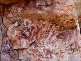
The Cueva de las Manos is a famous site in Santa Cruz, Argentina. A cave at the foot of a cliff is covered in wall paintings, particularly the negative images of hundreds of hands, believed to date from around 8000 BC.[10]
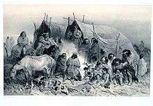
Based on artifacts found in the region, it appears that hunting of guanaco, and to a lesser extent rhea (ñandú), were the primary food sources of tribes living on the eastern plains .[10] It is unclear whether the megafauna of Patagonia, including the ground sloth and horse, were extinct in the area before the arrival of humans, although this is now the more widely accepted account. It is also not clear if domestic dogs were part of early human activity. Bolas are commonly found and were used to catch guanaco and rhea.[10] A maritime tradition existed along the Pacific coast; whose latest exponents were the Yámana to the south of Tierra del Fuego, the Kaweshqar between Taitao Peninsula and Tierra del Fuego and the Chono people in the Chonos Archipelago.
The indigenous peoples of the region included the Tehuelches, whose numbers and society were reduced to near extinction not long after the first contacts with Europeans. Tehuelches included the Gununa'kena to the north, Mecharnuekenk in south central Patagonia and the Aonikenk or Southern Tehuelche in the far South, north of the Magellan channel. On Isla Grande de Tierra del Fuego, the Selk'nam (Ona) and Haush (Mannekenk) lived in the north and south east respectively. In the archipelagos to the south of Tierra del Fuego were Yámana, with the Kawéskar (Alakaluf) in the coastal areas and islands in western Tierra del Fuego and the south west of the mainland.[10] In the Patagonian archipelagoes north of Taitao Peninsula lived the Chonos. These groups were encountered in the first periods of European contact with different lifestyles, body decoration and language, although it is unclear when this configuration emerged.
Towards the end of the 16th century, Mapuche-speaking agriculturalists penetrated the western Andes and from there across into the eastern plains and down to the far south. Through confrontation and technological ability, they came to dominate the other peoples of the region in a short period of time, and are the principal indigenous community today.[10] The Mapuche model of domination through technological superiority and armed confrontation was later repeated as Europeans implemented a succeeding but conceptually identical cycle, essentially replacing the position of the former dominators with a new, albeit predominately European class.
Early European exploration and Spanish conquest attempts (1520–1584)

It is possible that navigators such as Gonçalo Coelho and Amerigo Vespucci had reached the area (his own account of 1502 has it that they reached the latitude 52° S), however Vespucci`s failure to accurately describe the main geographical features of the region such as the Río de la Plata casts some doubt on whether they really did so.
The first detailed European description of a part of the coast of Patagonia is possibly mentioned in a voyage around 1512 (expedition traditionally attributed to the captain Diogo Ribeiro, who after his death was replaced by Estevão de Frois, and guided by the experienced captain, pilot and cosmographer João de Lisboa). The navigators, after reaching the Rio de la Plata, which they would explore again in the return voyage, contacting the Charrúa and other peoples, eventually reached the San Matias Gulf, at 42° S. The explorers reported that after going by the 40th parallel to south, along the coast, they found a "land" or "point extending into the sea", and further south, a Gulf. They round the Cape for nearly 300 km (186 mi) and sighted the continent on the southern side of the Gulf.[25][26]
The region of Patagonia was first fully described in 1520 by the expedition of Ferdinand Magellan, who on his passage along the coast named many of the more striking features – San Matías Gulf, Cape of 11,000 Virgins (now simply Cape Virgenes), and others. Magellan's fleet spent a difficult winter at what he named Puerto San Julián before resuming his voyage further south on 21 August 1520. During this time he encountered the local inhabitants, likely to be Tehuelche people, described by his reporter, Antonio Pigafetta, as giants called Patagons.[27]
Rodrigo de Isla, sent inland in 1535 from San Matías by Simón de Alcazaba Sotomayor (on whom western Patagonia had been conferred by Carlos V of Spain), is presumed to have been the first European to have traversed the great Patagonian plain. If the men under his charge had not mutinied, he might have been able to cross the Andes to reach the Chilean side.
Pedro de Mendoza, on whom the country was next bestowed, founded Buenos Aires, but did not venture to the south. Alonzo de Camargo (1539), Juan Ladrilleros (1557) and Hurtado de Mendoza (1558) helped to make known the western coasts, and Sir Francis Drake's voyage in 1577 down the eastern coast through the strait and northward by Chile and Peru was memorable, yet the description of the geography of Patagonia owes more to Pedro Sarmiento de Gamboa (1579–1580), who, devoting himself especially to the south-west region, made careful and accurate surveys. The settlements which he founded at Nombre de Dios and San Felipe were neglected by the Spanish government, the latter being abandoned before Thomas Cavendish visited it in 1587 and so desolate that he called it Port Famine. After the discovery of the route around Cape Horn the Spanish Empire lost interest in any further conquests in southern Patagonia, although it maintained its claim of a de jure sovereignty over the area.
In 1669, the district around Puerto Deseado, explored by John Davis about the same period, was claimed by Sir John Narborough for King Charles II of England.
Patagonian giants: early European perceptions
The first European explorers of Patagonia observed that the indigenous people in the region were taller than the average Europeans of the time, prompting some of them to believe that Patagonians were giants.
According to Antonio Pigafetta,[3] one of the Magellan expedition's few survivors and its published chronicler, Magellan bestowed the name "Patagão" (or Patagón) on the inhabitants they encountered there, and the name "Patagonia" for the region. Although Pigafetta's account does not describe how this name came about, subsequent popular interpretations gave credence to a derivation meaning 'land of the big feet'. However, this etymology is questionable. The term is most likely derived from an actual character name, "Patagón", a savage creature confronted by Primaleón of Greece, the hero in the homonymous Spanish chivalry novel (or knight-errantry tale) by Francisco Vázquez.[28] This book, published in 1512, was the sequel of the romance "Palmerín de Oliva," much in fashion at the time, and a favourite reading of Magellan. Magellan's perception of the natives, dressed in skins, and eating raw meat, clearly recalled the uncivilized Patagón in Vázquez's book. Novelist and travel writer Bruce Chatwin suggests etymological roots of both Patagon and Patagonia in his book, In Patagonia,[29] noting the similarity between "Patagon" and the Greek word παταγος, which means "a roaring" or "gnashing of teeth" (in his chronicle, Pigafetta describes the Patagonians as "roaring like bulls").
The main interest in the region sparked by Pigafetta's account came from his reports of their meeting with the local inhabitants, whom they claimed to measure some nine to twelve feet in height —"...so tall that we reached only to his waist"—, and hence the later idea that Patagonia meant "big feet". This supposed race of Patagonian giants or Patagones entered into the common European perception of this little-known and distant area, to be further fuelled by subsequent reports of other expeditions and famous-name travellers like Sir Francis Drake, which seemed to confirm these accounts. Early charts of the New World sometimes added the legend regio gigantum ("region of the giants") to the Patagonian area. By 1611 the Patagonian god Setebos (Settaboth in Pigafetta) was familiar to the hearers of The Tempest.
The concept and general belief persisted for a further 250 years, and was to be sensationally re-ignited in 1767 when an "official" (but anonymous) account was published of Commodore John Byron's recent voyage of global circumnavigation in HMS Dolphin. Byron and crew had spent some time along the coast, and the publication (Voyage Round the World in His Majesty's Ship the Dolphin) seemed to give proof positive of their existence; the publication became an overnight best-seller, thousands of extra copies were to be sold to a willing public, and other prior accounts of the region were hastily re-published (even those in which giant-like folk were not mentioned at all).
However, the Patagonian giant frenzy was to die down substantially only a few years later, when some more sober and analytical accounts were published. In 1773 John Hawkesworth published on behalf of the Admiralty a compendium of noted English southern-hemisphere explorers' journals, including that of James Cook and John Byron. In this publication, drawn from their official logs, it became clear that the people Byron's expedition had encountered were no taller than 6-foot-6-inch (1.98 m), very tall but by no means giants. Interest soon subsided, although awareness of and belief in the myth persisted in some quarters even up into the 20th century.[30]
Scientific exploration (1764–1842)
In the second half of the 18th century, European knowledge of Patagonia was further augmented by the voyages of the previously mentioned John Byron (1764–1765), Samuel Wallis (1766, in the same HMS Dolphin which Byron had earlier sailed in) and Louis Antoine de Bougainville (1766). Thomas Falkner, a Jesuit who resided near forty years in those parts, published his Description of Patagonia (Hereford, 1774); Francisco Viedma founded El Carmen, nowadays Carmen de Patagones and Antonio settled the area of San Julian Bay, where he founded the colony of Floridablanca and advanced inland to the Andes (1782). Basilio Villarino ascended the Rio Negro (1782).
Two hydrographic surveys of the coasts were of first-rate importance: the first expedition (1826–1830) including HMS Adventure and HMS Beagle under Phillip Parker King, and the second (1832–1836) being the voyage of the Beagle under Robert FitzRoy. The latter expedition is particularly noted for the participation of Charles Darwin who spent considerable time investigating various areas of Patagonia onshore, including long rides with gauchos in Río Negro, and who joined FitzRoy in a 200 miles (320 kilometres) expedition taking ships boats up the course of the Santa Cruz river.
Chilean and Argentine colonisation (1843–1902)
In the early 19th century the araucanization of the natives of northern Patagonia intensified and a lot of Mapuches migrated to Patagonia to live as nomads raising cattle or pillaging the Argentine countryside. The cattle stolen in the incursions (malones) would later be taken to Chile through the mountain passes and traded for goods, especially alcoholic beverages. The main trail for this trade was called Camino de los chilenos and run a length of about 1000 km from the Buenos Aires Province to the mountain passes of Neuquén Province. The lonco Calfucurá crossed the Andes from Chile to the Pampas around 1830 after a call from the governor of Buenos Aires, Juan Manuel de Rosas, to fight the Boroanos tribe. In 1859 he attacked Bahía Blanca in Argentina with 3,000 warriors. As in the case of Calfucura many other bands of Mapuches got involved in the internal conflicts of Argentina until Conquest of the Desert. To counter the cattle raids a trench called Zanja de Alsina was built by Argentina in the pampas in the 1870s.
In the mid-19th century the newly independent nations of Argentina and Chile began an aggressive phase of expansion into the south, increasing confrontation with the indigenous populations. In 1860, a French adventurer Orelie-Antoine de Tounens proclaimed himself king of The Kingdom of Araucania and Patagonia of the Mapuche.
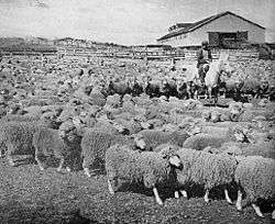
Following the last instructions of Bernardo O'Higgins, the Chilean president Manuel Bulnes sent an expedition to the Strait of Magellan and founded Fuerte Bulnes in 1843. Five years later, the Chilean government moved the main settlement to the current location of Punta Arenas, the oldest permanent settlement in Southern Patagonia. The creation of Punta Arenas was instrumental in making Chile's claim of the Strait of Magellan permanent. In the 1860s sheep from the Falkland Islands were introduced to the lands around the Straits of Magellan, and throughout the 19th century the sheepfarming grew to be the most important economic sector in southern Patagonia.
Captain George Chaworth Musters in 1869 wandered in company with a band of Tehuelches through the whole length of the country from the strait to the Manzaneros in the north-west, and collected a great deal of information about the people and their mode of life.
The Conquest of the Desert and the 1881 treaty
Argentine authorities worried that the strong connections Araucanized tribes had with Chile would allegedly gave Chile certain influence over the pampas.[31] Argentine authorities feared an eventual war with Chile over Patagonia where the natives would side with the Chileans and that it would therefore be fought in the vicinities of Buenos Aires.[31]
The decision of planning and executing the Conquest of the Desert was probably triggered by the 1872 attack of Cufulcurá and his 6,000 followers on the cities of General Alvear, Veinticinco de Mayo and Nueve de Julio, where 300 criollos were killed, and 200,000 heads of cattle taken.
In the 1870s the Conquest of the Desert was a controversial campaign by the Argentine government, executed mainly by General Julio Argentino Roca, to subdue or, some claim, to exterminate the native peoples of the South.
In 1885 a mining expeditionary party under the Romanian adventurer Julius Popper landed in southern Patagonia in search of gold, which they found after travelling southwards towards the lands of Tierra del Fuego. This further opened up some of the area to prospectors. European missionaries and settlers arrived through the 19th and 20th centuries, notably the Welsh settlement of the Chubut Valley.
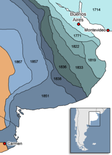
During the first years of the 20th century, the border between the two nations in Patagonia was established by the mediation of the British crown. But it has undergone a lot of modifications since then, being the last conflict solved in 1994 by an arbitral tribunal constituted in Rio de Janeiro, granting Argentina sovereignty over the Southern Patagonia Icefield, Cerro Fitz Roy and Laguna del Desierto.[32][33]
Until 1902, a large proportion of Patagonia's population were natives of Chiloé Archipelago (Chilotes) who worked as peons in large livestock farming estancias. As manual labour they had status below the gauchos and the Argentine, Chilean and European landowners and administrators.
Before and after 1902, when the boundaries were drawn, a lot of Chilotes were expelled from the Argentine side due to fear of what having a large Chilean population in Argentina could lead into in the future. These workers founded the first inland Chilean settlement in what is now the Aysén Region;[34][35] Balmaceda. Lacking good grasslands on the forest-covered Chilean side, the immigrants burned down the forest, setting fires that could last more than two years.[35]
Economy
The area's principal economic activities have been mining, whaling, livestock (notably sheep throughout) agriculture (wheat and fruit production near the Andes towards the north), and oil after its discovery near Comodoro Rivadavia in 1907.[36]
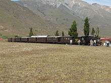
Energy production is also a crucial part of the local economy. Railways were planned to cover continental Argentine Patagonia to serve the oil, mining, agricultural and energy industries, and a line was built connecting San Carlos de Bariloche to Buenos Aires. Portions of other lines were built to the south, but the only lines still in use are La Trochita in Esquel, the 'Train of the End of the World' in Ushuaia, both heritage lines,[37] and a short run Tren Histórico de Bariloche to Perito Moreno.
In the western forest covered Patagonian Andes and archipelagoes wood lodging has historically been an important part of the economy, and was driving force behind the colonization of the areas of Nahuel Huapi and Lácar lakes in Argentina and Guaitecas Archipelago in Chile.
Livestock

Sheep farming introduced in the late 19th century has been a principal economic activity. After reaching its heights during the First World War, the decline in world wool prices affected sheep farming in Argentina. Nowadays about half of Argentina's 15 million sheep are in Patagonia, a percentage that is growing as sheep farming disappears in the Pampa (to the North). Chubut (mainly Merino) is the top wool producer with Santa Cruz (Corriedale and some Merino) second. Sheep farming revived in 2002 with the devaluation of the peso and firmer global demand for wool (led by China and the EU). Still there is little investment in new abbatoirs (mainly in Comodoro Rivadavia, Trelew and Rio Gallegos), and often there are phytosanitary restrictions to the export of sheep meat. Extensive valleys in the Cordilleran range have provided sufficient grazing lands, and the low humidity and weather of the southern region make raising Merino and Corriedale sheep common.
Livestock also includes small numbers of cattle, and in lesser numbers pigs and horses. Sheep farming provides small but important jobs located in rural areas where there is little else.
Tourism

In the second half of the 20th century, tourism became an ever more important part of Patagonia's economy. Originally a remote backpacking destination, the region has attracted increasing numbers of upmarket visitors, cruise passengers rounding Cape Horn or visiting Antarctica, and adventure and activity holiday-makers. Principal tourist attractions include the Perito Moreno glacier, the Valdés Peninsula, the Argentine Lake District and Ushuaia and Tierra del Fuego. Tourism has created new markets locally and for export for traditional crafts such as Mapuche handicrafts, guanaco textiles, and confectionery and preserves.[36]
A spin-off from increased tourism has been the buying of often enormous tracts of land by foreigners, often as a prestige purchase rather than for agriculture. Buyers have included Sylvester Stallone, Ted Turner and Christopher Lambert, and most notably Luciano Benetton, Patagonia's largest landowner.[36] His Compañia de Tierras Sud has brought new techniques to the ailing sheep-rearing industry and sponsored museums and community facilities, but has been controversial particularly for its treatment of local Mapuche communities.[38]
Energy
At the urging of the Chilean government, the Spanish company Endesa hopes to build a number of large hydro-electric dams in the Chilean Patagonia, which has raised environmental concerns from a large number of local and international NGOs. The first dams proposed would be built on the Baker and Pascua rivers, but dams have also been proposed on others, including the famed Futaleufú River in Chile and Santa Cruz river in Argentina. The dams would affect the minimum ecological flows and threaten the fishing, wilderness-tourism and agricultural interests along the river. The electricity would be fed into high-voltage lines (to be built by a Canadian company) and taken 1,200 miles (1,900 km) north to the industry and mining hub around Santiago. The lines would cut through a number of previously pristine national parks and protected areas. The rightist Piñera government considered the power to be essential for economic growth, while opponents claimed it would destroy Patagonia's growing tourism industry. On June 11, 2014, the new leftist Bachelet government rejected the dam project, estimated to be worth about 8 billion dollars, after years of pressure from environmental groups.
Due to its sparse rainfall in agricultural areas, Argentine Patagonia already has numerous dams for irrigation, some of which are also used for hydropower. Coal is mined in the Rio Turbio area and used for electrical generation. Patagonia's notorious winds have already made the area Argentina's main source of wind power, and there are plans for major increases in wind power generation. Patagonia has always been Argentina's main area, and Chile's only area, of conventional oil and gas production. Oil and gas have played an important role in the rise of Neuquén-Cipolleti as Patagonia's most populous urban area, and in the growth of Comodoro Rivadavia,[39] Punta Arenas, and Rio Grande as well. The development of the Neuquén basin's enormous unconventional oil and gas reserves through hydraulic fracturing has just begun, but the YPF-Chevron Loma Campana field in the Vaca Muerta formation is already the world's largest producing shale oil field outside North America according to YPF CEO Miguel Gallucio.
Cuisine
Argentine Patagonian cuisine is largely the same as the cuisine of Buenos Aires – grilled meats and pasta – with extensive use of local ingredients and less use of those products which have to be imported into the region. Lamb is considered the traditional Patagonian meat, grilled for several hours over an open fire. Some guide books have reported that game, especially guanaco and introduced deer and boar, are popular in restaurant cuisine. However, since the guanaco is a protected animal in both Chile and Argentina, it is unlikely to appear commonly as restaurant fare. Trout and centolla (king crab) are also common, though over-fishing of centolla has made it increasingly scarce. In the area around Bariloche, there is a noted Alpine cuisine tradition, with chocolate bars and even fondue restaurants, and tea rooms are a feature of the Welsh communities in Gaiman and Trevelin as well as in the mountains.[36] Since the mid-1990s there has been some success with winemaking in Argentine Patagonia, especially in Neuquén.
Foreign land buyer's issue
Foreign investors, including Italian multinational Benetton Group, Ted Turner, Joseph Lewis[40] and the environmentalist Douglas Tompkins, own major land areas. This situation has caused several conflicts with local inhabitants and the governments of Chile and Argentina; for example the opposition by Douglas Tompkins to the planned route for Carretera Austral in Pumalín Park. A scandal is also brewing about two properties owned by Ted Turner: the estancia La Primavera, located inside Nahuel Huapi National Park; and the estancia Collón Cura.[40] Benetton has faced criticism from Mapuche organizations, including Mapuche International Link, over its purchase of traditional Mapuche lands in Patagonia. The Curiñanco-Nahuelquir family was evicted from their land in 2002 following Benetton's claim to it, but the land was restored in 2007.[41]
Gallery
 Nahuel Huapi Lake, near Bariloche, Argentina Chaitén volcano stretching across Patagonia into San Jorge Basin in the Atlantic Ocean
 Satellite view of the Perito Moreno Glacier (Santa Cruz Province) and the Andean ice-sheet
%2C_Patagonia%2C_Road_Y-50_towards_Rio_Verde.JPG) Road Y-50 towards Estancia Rio Verde, Magallanes, Chile
Road Y-50 towards Estancia Rio Verde, Magallanes, Chile%2C_Patagonia%2C_Laguna_Cabeza_de_Mar.JPG) Laguna Cabeza de Mar, 50 km north of Punta Arenas, Magallanes, Chile
Laguna Cabeza de Mar, 50 km north of Punta Arenas, Magallanes, Chile Perito Moreno Glacier, Santa Cruz Province, Argentina
 The city of Trelew
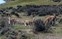
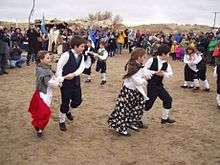 Welsh settlement in Patagonia
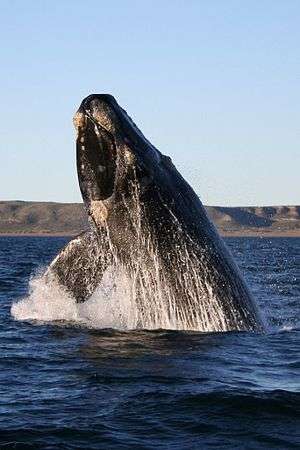 Southern right whale in Península Valdés, Argentina.
See also
- Domuyo
- Francisco Moreno Museum of Patagonia
- Kingdom of Araucania and Patagonia
- Lago Puelo National Park
- Lanín volcano
- Lanín National Park
- List of deserts by area
- Los Alerces National Park
- Los Glaciares National Park
- Mount Hudson
- Nahuel Huapi National Park
- Patagonian Expedition Race
- Patagonian Ice Sheet
- Southern Cone
- Torres del Paine National Park
- Y Wladfa
Notes
- ↑ The Late Cenozoic of Patagonia and Tierra del Fuego Volumen 11 de Developments in quaternary science, pág. 13. Autor: Jorge Rabassa. Editor: Jorge Rabassa. Editor: Elsevier, 2008. ISBN 0-444-52954-3, 9780444529541
- ↑ Ciudadanía, territorio y desarrollo endógeno: resistencias y mediaciones de las políticas locales en las encrucijadas del neoliberalismo. Pág. 205. Autores: Rubén Zárate, Liliana Artesi, Oscar Madoery. Editor: Editorial Biblos, 2007. ISBN 950-786-616-7, 9789507866166
- 1 2 Antonio Pigafetta, Relazione del primo viaggio intorno al mondo, 1524: "Il capitano generale nominò questi popoli Patagoni." A Brief Declaration of the Vyage abowte the Worlde by Antonie Pygafetta Vincentine, Rycharde Eden, The Decades of the Newe Worlde or West India, London, William Powell, 1555. The original word would probably be in Magellan's native Portuguese (patagão) or the Spanish of his men (patagón). It has been interpreted later as "big foot" but the etymology refers to a literary character in a Spanish novel of the early 16th century (see text). Anthony Munday, The Famous and Renowned Historie of Primaleon of Greece, 1619, cap.XXXIII: “How Primaleon… found the Grand Patagon ”.
- ↑ Fondebrider, Jorge (2003). "Chapter 1 – Ámbitos y voces". Versiones de la Patagonia (in Spanish) (1st ed.). Buenos Aires, Argentina: Emecé Editores S.A. p. 29. ISBN 950-04-2498-3.
- ↑ Robert Silverberg (2011). "The Strange Case of the Patagonian Giants" (PDF). Asimov's Science Fiction.
To the voyagers of the sixteenth and seventeenth centuries, when the average height of an adult European male was just over five feet [1.55 meters], the Patagonians surely must have looked very large, as, to any child, all adults seem colossal. Then, too, an element of understandable human exaggeration must have entered these accounts of men who had traveled so far and endured so much, and the natural wish not to be outdone by one’s predecessors helped to produce these repeated fantasies of Goliaths ten feet tall or even more.
- ↑ Nueva Revista de Filología Hispánica 59 (1): pp. 37-78. 2011. ISSN 0185-0121
- ↑ "Argentina: CIA The World Factbook, est July 2009". Cia.gov. Retrieved 20 December 2012.
- ↑ "Chile: CIA The World Factbook, est July 2009". Cia.gov. Retrieved 20 December 2012.
- ↑ "Aseguran que en Bariloche viven 30 mil personas más que las censadas ::: ANGOSTURA DIGITAL - DIARIO DE VILLA LA ANGOSTURA Y REGION DE LOS LAGOS - PATAGONIA ARGENTINA - Actualidad, cuentos, efemerides, turismo, nieve, pesca, montañismo,cursos, historia, reportajes". Retrieved 25 October 2014.
- 1 2 3 4 5 6 7 8 9 10 11 12 13 Patagonia: Natural History, Prehistory and Ethnography at the Uttermost End of the Earth, C. McEwan, L.A. and A. Prieto (eds), Princeton University Press with British Museum Press, 1997. ISBN 0-691-05849-0
- ↑ Jaramillo, Jessica. "Entrevista al Dr. Víctor Alberto Ramos, Premio México Ciencia y Tecnología 2013" (in Spanish).
Incluso ahora continúa la discusión sobre el origen de la Patagonia, la cual lleva más de veinte años sin lograr un consenso entre la comunidad científica. Lo que propone el grupo de investigación en el que trabaja el geólogo es que la Patagonia se originó en el continente Antártico, para después separarse y formar parte de Gondwana, alrededor de 250 a 270 millones de años.
- ↑ Pankhurst, R.J.; Rapela, C.W.; López de Luchi, M.G.; Rapalini, A.E.; Fanning, C.M.; Galindo, C. (2014). "The Gondwana connections of northern Patagonia". Journal of the Geological Society, London. 171: 313–328.
- ↑ "BBC News - 'Biggest dinosaur ever' discovered". BBC News. Retrieved 25 October 2014.
- ↑ Though not without it where the formations surface; see Chacaicosaurus and Mollesaurus from the Los Molles, and Caypullisaurus, Cricosaurus, Geosaurus, Herbstosaurus, and Wenupteryx from the Vaca Muerta.
- ↑ U.S. Energy Information Administration, Technically Recoverable Shale Oil and Shale Gas Resources: An Assessment of 137 Shale Formations in 41 Countries Outside the United States, June 2013, pp. V-1 through V-13. According to the same study, the Austral (Argentine name)/Magallanes (Chilean name) basin under the southern Patagonian mainland and Tierra del Fuego may also have massive hydrocarbon reserves in early Cretaceous shales; see pp. V-23 and VII-17 in particular. On May 21, 2014, YPF also announced the first oil and gas discovery in the D-129 shale formation of the Golfo San Jorge area in Chubut, and on August 14, 2014, the first shale oil discovery in yet another Cretaceous formation in the Neuquén basin, the Valanginian/Hauterivian Agrio formation; see http://www.ypf.com/YPFHoy/YPFSalaPrensa/Paginas/YPF-confirmo-la-presencia-de-hidrocarburos-no-convencionales-en-Chubut.aspx, and http://www.ypf.com/YPFHoy/YPFSalaPrensa/Paginas/Galuccio-inauguro-el-Espacio-de-la-Energia-de-YPF-en-Tecnopolis.aspx
- ↑ Southern Chile warned of high radiation levels under ozone hole, CNN.com, 10 October 2000, accessed 2006-08-11
- 1 2 3 WCS. "Patagonia and Southern Andean Steppe, Argentina". Saving Wild Places. Wildlife Conservation Society. Retrieved 19 June 2015.
- ↑ Rhys, David Hall (1976). A geographic study of the Welsh colonization in Chubut, Patagonia. Ann Arbor, Michigan: Xerox University Microfilms. pp. 84–88.
- ↑ WCS. "Andean condor". Saving wildlife. World Conservation Society. Retrieved 19 June 2015.
- ↑ UNESCO. "Península Valdés". UNESCO World Heritage Centre. UNESCO. Retrieved 19 June 2015.
- 1 2 Baigun, C., and Ferriz, R.A. (January 2003). Distribution patterns of freshwater fishes in Patagonia (Argentina). Organisms Diversity & Evolution 3: 151-159.
- ↑ Christopher C. Tudge (2003). "Endemic and enigmatic: the reproductive biology of Aegla (Crustacea: Anomura: Aeglidae) with observations on sperm structure". Memoirs of Museum Victoria. 60 (1): 63–70.
- ↑ SCHLOSSBERG, TATIANA (17 June 2016). "12,000 Years Ago, Humans and Climate Change Made a Deadly Team". NYT. NYC. Retrieved 19 June 2016.
- ↑ C. Michael Hogan (2008) Cueva del Milodon, The Megalithic Portal, ed. A. Burnham
- ↑ Oskar Hermann Khristian Spate. The Spanish Lake. Canberra: ANU E Press, 2004. p. 37.
- ↑ Newen Zeytung auss Presillg Landt (in ancient german and portuguese) Newen Zeytung auss Presillg Landt
- ↑ Laurence Bergreen. Over the Edge of the World. Harper Perennial, 2003. p. 163. ISBN 0-06-621173-5.
- ↑ The Cambridge Encyclopedia of Human Growth and Development, By Stanley J. Ulijaszek, Francis E. Johnston, M. A. Preece. Cambridge University Press, 1998, p. 380: "Patagonian Giants: Myths and Possibilities."
- ↑ Chatwin, Bruce. In Patagonia (1977). Ch. 49
- ↑ Carolyne Ryan. "European Travel Writings and the Patagonian giants". Lawrence University. Retrieved 24 October 2013.
- 1 2 "Argentina and Chile: The Struggle For Patagonia 1843-1881". 36: 347–363. JSTOR 981291.
- ↑ Rosa, Carlos Leonardo de la (1 January 1998). "Acuerdo sobre los hielos continentales: razones para su aprobación". Ediciones Jurídicas Cuyo – via Google Books.
- ↑ es:Disputa de la laguna del Desierto
- ↑ "Coihaique – Ciudades y Pueblos del sur de Chile". Turistel.cl. Retrieved 20 August 2012.
- 1 2 Luis Otero, La Huella del Fuego: Historia de los bosques y cambios en el paisaje del sur de Chile (Valdivia, Editorial Pehuen)
- 1 2 3 4 Time Out Patagonia, Cathy Runciman (ed), Penguin Books, 2002. ISBN 0-14-101240-4
- ↑ History of the Old Patagonian Express, La Trochita, accessed 2006-08-11
- ↑ 'The Invisible Colours of Benetton', Mapuche International Link, accessed 2006-08-11
- ↑ Comodoro's coat of arms bears an oil derrick in the center.
- 1 2 "Rivers of bloodfrom Patagonia-argentina.com".
- ↑ "Recovered Mapuche territory in Patagonia: Benetton vs. Mapuche". MAPU Association. Retrieved 7 April 2008.
References
![]() This article incorporates text from a publication now in the public domain: Chisholm, Hugh, ed. (1911). "Patagonia". Encyclopædia Britannica (11th ed.). Cambridge University Press.
This article incorporates text from a publication now in the public domain: Chisholm, Hugh, ed. (1911). "Patagonia". Encyclopædia Britannica (11th ed.). Cambridge University Press.
Further reading
- The Last Cowboys at the End of the World: The Story of the Gauchos of Patagonia, Nick Reding, 2002. ISBN 0-609-81004-9
- The Old Patagonian Express, Paul Theroux, 1979.
- In Patagonia, Bruce Chatwin, 1977 and 1988. ISBN 0-14-243719-0
- Patagonia: A Cultural History, Chris Moss, 2008. ISBN 978-1-904955-38-2
- Patagonia: A Forgotten Land: From Magellan to Peron, C. A. Brebbia, 2006. ISBN 978-1-84564-061-3
- The Wild Shores of Patagonia: The Valdés Peninsula & Punta Tombo, Jasmine Rossi, 2000. ISBN 0-8109-4352-2
- Luciana Vismara, Maurizio OM Ongaro, PATAGONIA – E-BOOK W/ UNPUBLISHED FOTOS, MAPS, TEXTS (Formato Kindle – 6 November 2011) – eBook Kindle
- Adventures in Patagonia: a missionary's exploring trip, Titus Coan, 1880. Library of Congress Control Number 03009975. A list of writings relating to Patagonia, 320-21.
External links
| Wikimedia Commons has media related to Patagonia. |
- Planning a vacation to Patagonia GUIDE
- Photos from Chilean Patagonia (2008–2011) by Jorge Uzon
- Patagon Journal, magazine about Patagonia
- Aborigines of Patagonia
- Patagonia SinRepresas (Spanish)
- Patagonia de Chile (Spanish)
- Gallery of photos from Patagonia – February
- 'Race to the End of the Earth' – article about competing in Patagonian Expedition Race
- 'The Accidental Explorer' – article about travels in Patagonia
Coordinates: 41°48′37″S 68°54′23″W / 41.81015°S 68.90627°W