Elba
| Native name: <span class="nickname" ">Isola d'Elba | |
|---|---|
 | |
 | |
| Geography | |
| Location | Tyrrhenian Sea |
| Coordinates | 42°45.71′N 10°14.45′E / 42.76183°N 10.24083°ECoordinates: 42°45.71′N 10°14.45′E / 42.76183°N 10.24083°E |
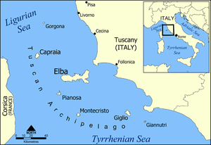
| Archipelago | Tuscan Archipelago |
| Total islands | 7 |
| Major islands | Elba, Gorgona, Capraia, Pianosa, Montecristo, Isola del Giglio, and Giannutri |
| Area | 224 km2 (86 sq mi) |
| Length | 29 km (18 mi) |
| Width | 18 km (11.2 mi) |
| Coastline | 147 km (91.3 mi) |
| Highest elevation | 1,018 m (3,340 ft) |
| Highest point | Monte Capanne |
| Administration | |
|
Italy | |
| Region |
|
| Province | Livorno |
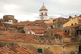
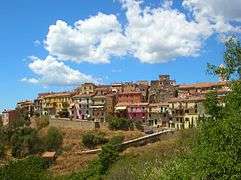
| Communes of Elba | Portoferraio, Campo nell'Elba, Capoliveri, Marciana, Marciana Marina, Porto Azzurro, Rio Marina and Rio nell'Elba |
| Largest settlement | Portoferraio (pop. 12,013) |
| Demographics | |
| Population | 32,162 (December, 2014[1]) |
| Pop. density | 140 /km2 (360 /sq mi) |
Elba (Italian: isola d'Elba, pronounced [ˈiːzola ˈdelba]; Latin: Ilva; Ancient Greek: Αἰθαλία, Aithalia) is a Mediterranean island in Tuscany, Italy, 10 kilometres (6.2 mi) from the coastal town of Piombino, the largest island of the Tuscan Archipelago. Elba is also part of the Arcipelago Toscano National Park,[2] and the third largest island in Italy, after Sicily and Sardinia. It is located in the Tyrrhenian Sea, about 50 kilometres (30 mi) east of the French island of Corsica.
The island is part of the province of Livorno and is divided into eight municipalities, with a total population of about 30,000 inhabitants, which increases considerably during the summer. The municipalities are Portoferraio, which is also the island's principal town, along with Campo nell'Elba, Capoliveri, Marciana, Marciana Marina, Porto Azzurro, Rio Marina, and Rio nell'Elba.
Geology
Elba is the largest remaining stretch of land from the ancient tract that once connected the Italian peninsula to Corsica. The northern coast faces the Ligurian Sea, the eastern coast the Piombino Channel, the southern coast the Tyrrhenian Sea, and the Corsica Channel divides the western tip of the island from neighbouring Corsica.
The island itself is made up of slices of rocks which once formed part of the ancient Tethyan seafloor.[3] These rocks have been through at least two orogenies, the Alpine orogeny and the Apennine orogeny. The second of these two events was associated with subduction of the Tethyan oceanic crust underneath Italy and the obduction of parts of the ancient seafloor onto the continents. Later extension within the stretched inner part of the Apennine mountains caused adiabatic melting and the intrusion of the Mount Capanne and the La Serra-Porto Azzuro granitoids. These igneous bodies brought with them skarn fluids which dissolved and replaced some of the carbonate units, precipitating iron-rich minerals in their place. One of the iron-rich minerals, ilvaite, was first identified on the island and takes its name from the Latin word for Elba. More recently, high-angle faults formed within the tectonic pile, allowing for the migration of iron-rich fluids through the crust. The deposits left behind by these fluids formed the island's rich seams of iron ore.
The terrain is quite varied, and is thus divided into several areas based on geomorphology. The mountainous and most recent part of the island can be found to the west, the centre of which is dominated by Mount Capanne (1,018 metres/3,340 ft), also called the "roof of the Tuscan Archipelago". The mountain is home to many animal species including the mouflon and wild boar, two species that flourish despite the continuous influx of tourists. The central part of the island is a mostly flat section with the width being reduced to just four kilometres (2.5 miles). It is where the major centres can be found: Portoferraio, Campo nell'Elba. To the east is the oldest part of the island, formed over 3 million years ago.[4] In the hilly area, dominated by Monte Calamita, are the deposits of iron that made Elba famous.
Hydrography
Rivers rarely exceed 3 kilometres (2 miles) in length, and it is common for the shorter ones to dry up during the summer. The largest rivers, sorted by length, are:
- Fosso San Francesco 6.5 kilometres (4.0 mi);
- Fosso Barion, 5.1 kilometres (3.2 mi);
- Fosso Redinoce, 2 kilometres (1.2 mi)
Between Poggio and Marciana, at the foot of Mount Capanne, is a spring called Fonte Napoleone, known for its quality.
Climate
The climate of the island is predominantly Mediterranean, except for Mount Capanne, where winters tend to be moderately cold. Precipitation is concentrated in autumn and comprises a normal rainfall. The island lies in the rain shadow of the large and mountainous island of Corsica, so precipitation totals are somewhat reduced from the mainland (most of the island receives less than 750 mm (30 inches) annually). Snowfall in winter is rare in the lowlands, and melts quickly. The table below shows the average temperatures for the islands by month.
| Climate data for Elba | |||||||||||||
|---|---|---|---|---|---|---|---|---|---|---|---|---|---|
| Month | Jan | Feb | Mar | Apr | May | Jun | Jul | Aug | Sep | Oct | Nov | Dec | Year |
| Record high °C (°F) | 16.2 (61.2) |
18.0 (64.4) |
20.0 (68) |
22.4 (72.3) |
29.6 (85.3) |
32.0 (89.6) |
34.3 (93.7) |
36.1 (97) |
32.0 (89.6) |
25.0 (77) |
24.6 (76.3) |
16.8 (62.2) |
36.1 (97) |
| Average high °C (°F) | 9.6 (49.3) |
10.0 (50) |
12.0 (53.6) |
14.2 (57.6) |
18.8 (65.8) |
22.7 (72.9) |
26.5 (79.7) |
26.7 (80.1) |
22.6 (72.7) |
18.0 (64.4) |
13.4 (56.1) |
10.5 (50.9) |
17.08 (62.76) |
| Daily mean °C (°F) | 7.4 (45.3) |
7.5 (45.5) |
9.2 (48.6) |
11.4 (52.5) |
15.6 (60.1) |
19.3 (66.7) |
22.7 (72.9) |
23.1 (73.6) |
19.5 (67.1) |
15.4 (59.7) |
11.2 (52.2) |
8.5 (47.3) |
14.23 (57.63) |
| Average low °C (°F) | 5.3 (41.5) |
5.0 (41) |
6.3 (43.3) |
8.5 (47.3) |
12.3 (54.1) |
15.8 (60.4) |
19.0 (66.2) |
19.5 (67.1) |
16.4 (61.5) |
12.9 (55.2) |
9.0 (48.2) |
6.5 (43.7) |
11.38 (52.46) |
| Record low °C (°F) | −7.4 (18.7) |
−4.4 (24.1) |
−5.4 (22.3) |
1.2 (34.2) |
3.4 (38.1) |
5.0 (41) |
12.2 (54) |
11.6 (52.9) |
7.6 (45.7) |
2.0 (35.6) |
−1.0 (30.2) |
−5.4 (22.3) |
−7.4 (18.7) |
| Average precipitation mm (inches) | 59.5 (2.343) |
75.6 (2.976) |
56.2 (2.213) |
57.8 (2.276) |
31.6 (1.244) |
26.8 (1.055) |
13.8 (0.543) |
41.5 (1.634) |
75.0 (2.953) |
101.6 (4) |
88.7 (3.492) |
50.5 (1.988) |
678.6 (26.717) |
| Average precipitation days (≥ 1.0 mm) | 6.7 | 6.2 | 6.9 | 7.0 | 5.0 | 3.5 | 1.6 | 2.4 | 5.0 | 7.9 | 7.3 | 5.8 | 65.3 |
| Average relative humidity (%) | 77 | 76 | 75 | 76 | 76 | 73 | 68 | 72 | 76 | 80 | 81 | 79 | 75.8 |
| Mean monthly sunshine hours | 133.3 | 118.7 | 155.0 | 183.0 | 195.3 | 237.0 | 275.9 | 257.3 | 201.0 | 151.9 | 117.0 | 114.7 | 2,140.1 |
| Source #1: Servizio Meteorologico (temperature and precipitation data 1971-2000)[5] | |||||||||||||
| Source #2: Servizio Meteorologico (relative humidity and sun data 1961-1990)[6] | |||||||||||||
History


The island was originally inhabited by Ligures Ilvates who gave it the ancient name Ilva. It was well known from very ancient times for its iron resources and its valued mines. The Greeks called it Aethalia (Αιθαλία, "fume") after the fumes of the furnaces for the production of metal. Apollonius of Rhodes mentioned it briefly in his epic poem Argonautica describing that the Argonauts would have rested here during their travels and signs of their visit were still visible in the poet's day, including skin-coloured pebbles that they dried their hands on, and large stones which they used at discus. The text, however, may be unsound and Strabo (5.2.6) presented a slightly different account: "because the scrapings, which the Argonauts formed when they used their strigils, became congealed, the pebbles on the shore remain variegated still to this day."[7]
The island was invaded by the Etruscans and later (after 480 BC) by the Romans. In the middle ages, it was invaded by the Ostrogoths and the Lombards. Then it became a possession of the Republic of Pisa. The island was acquired by the Appiani, Lords of Piombino when Pisa was sold to the Visconti of Milan in 1398, who retained it for two centuries.
In 1544, the Barbary pirates from North Africa devastated Elba and the coasts of Tuscany.[8] In 1546, part of the island was handed over to Cosimo I de' Medici, who fortified Portoferraio and renamed it "Cosmopoli", while the rest of the island was returned to the Appiani in 1577. In 1596, Philip II of Spain captured Porto Azzurro and had two fortresses built there. In 1802, the island became a French possession and its economy flourished.
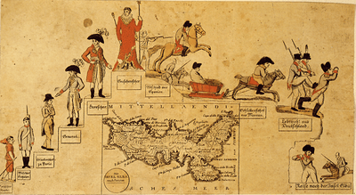
Following the Treaty of Fontainebleau, French Emperor Napoleon I was exiled to Elba after his forced abdication in 1814, and he arrived at Portoferraio on May 30, 1814. He was allowed to keep a personal guard of six hundred men. He was nominally sovereign of Elba, although the nearby sea was patrolled by the French and British navies. During the months that Napoleon stayed on the island, he carried out a series of economic and social reforms to improve the quality of life, partly to pass the time and partly out of a genuine concern for the well-being of the islanders. The restored Bourbons quickly reneged on the payments promised to Napoleon by Fontainebleau, however, and he was forced to make economies, raise taxation, and even attempt forced corvées. Napoleon stayed on Elba for 300 days. Hearing that the Congress of Vienna planned to remove him further from Europe and that the more popular and reformist Duke of Orleans was planning to replace his more hidebound relatives, ruining any chance of Napoleon's popular recall, the former emperor escaped on a ship under British colors to France on February 26, 1815, for the Hundred Days. After his defeat at Waterloo, he was subsequently exiled again, this time to the barren and isolated South Atlantic island of Saint Helena.
In the Congress of Vienna, the island was restored to the Grand Duchy of Tuscany. In 1860, it became part of the new unified Kingdom of Italy.
Elba was liberated from the Germans by the French 1er Corps d'Armée on June 17, 1944 in Opération Brassard. Faulty intelligence and strong defences made the battle more difficult than expected.[9]
BOAC Flight 781 crashed near Elba in 1954.

More recently, the island has become famed for its wine, and it is today a noted tourist resort.[10]
Transportation
The island is connected to the mainland via the four ferry companies, Toremar, Moby Lines, Blunavy and Corsica Ferries - Sardinia Ferries,[11] all offering routes between Piombino and Portoferraio, the capital located in the north, Cavo, Rio Marina and Porto Azzurro, on the east coast of the island.[12][13][14][15][16]
There is an airport on the island, Marina di Campo Airport. It is served by SkyWork Airlines and Silver Air with flights to Italian mainland and Switzerland[17]
Cycling
The island has a network of trails for road racers looking for more technical routes for their training, trails and dirt roads for bikers to have fun on, and accessible routes for families with children who need safe and relaxing routes. On the road from Rio nell'Elba going to Porto Azzurro is the “Fonte di Coppi”. Towards the end of his career Fausto Coppi, the “campionissimo”, came here to train on the roads of Elba. He still retained a celebrity status but was no longer at the peak of his career that ended with his death a few years later. The plaque on the fountain reads: "1960–2010, here the champion quenched his thirst, since fifty years on the run".
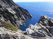
Gallery
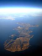 Aerial view of Elba
 Mount Capanne
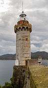 Lighthouse in Portoferraio
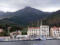
 Fetovaia beach
References
- ↑ "Istat official population estimates". Retrieved June 2015. Check date values in:
|access-date=(help) - ↑ "Elba". Parco nazionale dell'Arcipelago Toscano. 16 February 2009. Retrieved 15 January 2012.
- ↑ "The association of continental crust rocks with ophiolites in the Northern Apennines (Italy): implications for the continent-ocean transition in the Western Tethys" (PDF). els-cdn.com.
- ↑ http://ofioliti.it/index.php/ofioliti/article/view/137/137
- ↑ "ELBA/M. CALAMITA" (PDF). Servizio Meteorologico. Retrieved 13 October 2012.
- ↑ Elba -Monte Calamita "MONTE CALAMITA - ELBA" Check
|url=value (help). Servizio Meteorologico. Retrieved 13 October 2012. - ↑ Race, W. H. Apollonius Rhodius: Argonautica, Loeb Classical Library (2008), II. 654–58, pp. 381–3; see note 95 p. 383 for Strabo quote.
- ↑ David, Robert C. Christian Slaves, Muslim Masters: White Slavery in the Mediterranean, the Barbary Coast and Italy, 1500–1800, Palgrave Macmillan, 2004. ISBN 1-4039-4551-9
- ↑ McGrann, Bill. "Operation Brassard The Invasion Of Elba". BBC. Retrieved March 2010. Check date values in:
|access-date=(help) - ↑ "Food and Wine". Elba Island World. Retrieved March 2010. Check date values in:
|access-date=(help) - ↑ "Traversate traghetti Sardegna, Corsica e Isola d'Elba". CorsicaFerries / SardiniaFerries.
- ↑ "Ferries to Elba". Tuscany Live. Retrieved March 2010. Check date values in:
|access-date=(help) - ↑ "Ferries to the island of Elba". Ferry Elba Reservation. Retrieved March 2010. Check date values in:
|access-date=(help) - ↑ "Blunavy ticket reservation (EN)". Blunavy. Retrieved June 2011. Check date values in:
|access-date=(help) - ↑ "Toremar ticket reservation (IT)". Toremar. Retrieved June 2011. Check date values in:
|access-date=(help) - ↑ "Moby Lines ticket reservation (EN)". Moby Lines. Retrieved June 2011. Check date values in:
|access-date=(help) - ↑ "Home - Elba Island Airport". Retrieved 16 July 2016.
Further reading
- Chandler, David G. (1990). The Illustrated Napoleon. New York: Henry Holt & Co. ISBN 0-8050-0442-4.
External links
| Wikivoyage has a travel guide for Elba. |
| Wikimedia Commons has media related to Elba. |