Embalam
| Embalam | |
|---|---|
| Village | |
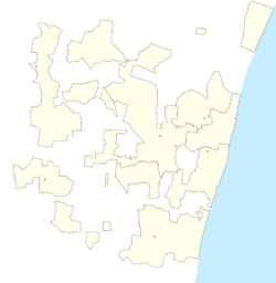 Embalam  Embalam Location in Puducherry, India | |
| Coordinates: 11°52′16″N 79°42′49″E / 11.871215°N 79.713514°ECoordinates: 11°52′16″N 79°42′49″E / 11.871215°N 79.713514°E | |
| Country |
|
| State | Puducherry |
| District | Pondicherry |
| Taluk | Bahour |
| Commune | Nettapakkam |
| Languages | |
| • Official | French, Tamil, English |
| Time zone | IST (UTC+5:30) |
| PIN | 605 106 |
| Telephone code | 0413 |
| Vehicle registration | PY-01 |
| Sex ratio | 50% ♂/♀ |
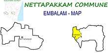
Embalam (Tamil: ஏம்பலம்) is a panchayat village[1] in Nettapakkam Commune in the Union Territory of Puducherry, India.
Geography
Embalam is bordered by Nallathur village (Tamil nadu) in the west, Sathamangalam in the north, Sembiapalayam in the east and Manaveli village (Tamil nadu) in the south and south-west.
Transport
Embalam is located at 18 km. from Pondicherry. Embalam can be reached directly by any bus running between Pondicherry and Maducarai via. Embalam.
Road Network
Embalam is connected to Pondicherry by Thavalakuppam-Embalam (RC-20) State Highway. Also Mangalam-Maducarai State Highway (RC-19) passes through Embalam
Politics
Embalam is a part of Embalam (Union Territory Assembly constituency) which comes under Puducherry (Lok Sabha constituency)
Gallery
-

Way to Embalam
-

Embalam Village Panchayat