Eresos-Antissa
| Eresos-Antissa Ερεσός-Άντισσα | |
|---|---|
 | |
 Eresos-Antissa | |
|
Location within the regional unit  | |
| Coordinates: 39°10′N 25°56′E / 39.167°N 25.933°ECoordinates: 39°10′N 25°56′E / 39.167°N 25.933°E | |
| Country | Greece |
| Administrative region | North Aegean |
| Regional unit | Lesbos |
| Municipality | Lesbos |
| • Municipal unit | 290.947 km2 (112.335 sq mi) |
| Elevation | 50 m (160 ft) |
| Population (2011)[1] | |
| • Municipal unit | 5,269 |
| • Municipal unit density | 18/km2 (47/sq mi) |
| Time zone | EET (UTC+2) |
| • Summer (DST) | EEST (UTC+3) |
| Postal code | 811 05 |
| Area code(s) | 22530 |
| Vehicle registration | MY |
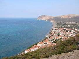
Eresos-Antissa (Greek: Ερεσός-Άντισσα) is a former municipality on the island of Lesbos, North Aegean, Greece. Since the 2011 local government reform it is part of the municipality Lesbos, of which it is a municipal unit.[2] It is located in the westernmost part of the island, and is the largest municipal unit of the island in land area at 290.947 km². Its population was 5,269 at the 2011 census. The seat of the municipality was in Eresos (pop. 1,086). The next largest towns are Antissa (908), Mesótopos (773), Vatoússa (574) and Chidira (472).
Notable people
- Terpander (7th century BC) poet and citharode
References
- ↑ "Απογραφή Πληθυσμού - Κατοικιών 2011. ΜΟΝΙΜΟΣ Πληθυσμός" (in Greek). Hellenic Statistical Authority.
- ↑ Kallikratis law Greece Ministry of Interior (Greek)
This article is issued from Wikipedia - version of the 11/1/2016. The text is available under the Creative Commons Attribution/Share Alike but additional terms may apply for the media files.