Escalante Petrified Forest State Park
| Escalante Petrified Forest State Park | |
| Utah State Park | |
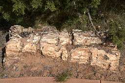 Large piece of petrified wood in Escalante Petrified Forest State Park | |
| Country | |
|---|---|
| State | |
| County | Garfield |
| Location | Escalante |
| - elevation | 5,900 ft (1,798 m) [1] |
| - coordinates | 37°47′16″N 111°37′46″W / 37.78778°N 111.62944°WCoordinates: 37°47′16″N 111°37′46″W / 37.78778°N 111.62944°W |
| Area | 1,350 acres (546.3 ha) [2] |
| Founded | 1963 [2] |
| Management | Utah State Parks |
| Visitation | 57,934 (2011) [3] |
| IUCN category | V - Protected Landscape/Seascape |
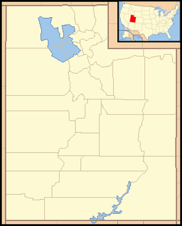 Location of Escalante Petrified Forest State Park in Utah | |
Escalante Petrified Forest State Park (also known as Escalante State Park) is a state park of Utah, USA, located a half-mile (0.8 km) north of the town of Escalante. A visitor center was built in 1991, and features displays of plant and marine fossils, petrified wood and fossilized dinosaur bones over 150 million years old (Upper Jurassic Period). The Petrified Forest Trail is a one-mile (1.6 km) loop, winding up the side of a mesa to the top where most of the fossil wood occurs. Logs two feet or more in diameter are seen at several places along the trail where it is eroding from the conglomerate capping the mesa. This conglomerate lies near the top of the Brushy Basin Member of the Morrison Formation.[4] The wood is multicolored (mostly red, yellow, white, and black) and was prized by hobbyists before the Park was established. The logs are believed to be of conifers that were transported by a river before being buried and later fossilized as agate. A 50 foot (15m) log is displayed near the trail head and is one of the most complete fossil logs known from the Morrison Formation.

The Sleeping Rainbows trail is an optional .75-mile (1.21 km) loop off the Petrified Forest Trail. This section is much steeper and requires scrambling and climbing over rocks.[5]
In 1954 Wide Hollow Reservoir was constructed to provide irrigation for the town of Escalante. The reservoir is stocked with rainbow trout and bluegill, and is popular for water sports including swimming, boating and fishing.
References
![]() This article incorporates public domain material from the website of the Division of Utah State Parks and Recreation.
This article incorporates public domain material from the website of the Division of Utah State Parks and Recreation.
- ↑ "Escalante Petrified Forest State Park: About the Park". Utah State Parks. Retrieved 2011-02-05.
- 1 2 "Escalante Petrified Forest State Park Resource Management Plan" (PDF). State of Utah Natural Resources: Division of Parks and Recreation. September 2005. Retrieved 2011-02-05.
- ↑ "Utah State Park 2011 Visitation" (PDF). Utah State Parks Planning. Retrieved 28 May 2012.
- ↑ Morgan, S., B.W. Lindsay and A.P. Williams 2010. Geology of Escalante State Park, Utah. Pp. 429-436 in The Geology of Utah Parks and Monuments. Utah Geological Association Publication 28
- ↑ "Escalante Petrified Forest State Park". Utah State Parks.
External links
| Wikimedia Commons has media related to Escalante Petrified Forest State Park. |