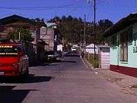
Esquipulas Palo Gordo
| Esquipulas Palo Gordo | |
|---|---|
 | |
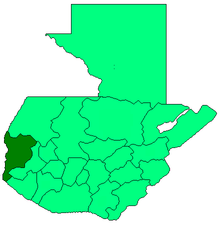
 Esquipulas Palo Gordo Location in Guatemala | |
| Coordinates: 14°56′31″N 91°49′33″W / 14.94194°N 91.82583°W | |
| Country |
|
| Department |
|
| Government | |
| • Mayor (2012-2020) | Juan Carlos Ochoa[1] (PP) |
| Climate | Cwb |
Esquipulas Palo Gordo (Spanish pronunciation: [eskiˈpulas ˈpalo ˈɣorðo]) is a municipality in the San Marcos department of Guatemala. The town was founded on 24th of December 1826 year. In the 1920s it was merged with San Marcos, but in 1948 it recovered its autonomy again.[2]
Political division
| Location | Name | Brief description |
|---|---|---|
| Town | Esquipulas Palo Gordo | |
| Villages | Tánil | Located by Ixtágel hill. |
| Fraternidad | Formerly "Hoyón Grande" and "Hoyón Chiquito". | |
| Carrizal | Previosluy known as "San Francisco" (1917). | |
| Villa Hermosa | Founded in 1902. | |
| Ojo de Agua | Its name is due to the presence of several water creeks in the area. | |
| Pojopón | Also known as Santa Cruz Pojopón. | |
| Cantón | Bethania | Previously known as «Cumbre de Paltazá» settlement, since it was right by Paltazá creek. |
| Settlements | El Paraíso | Previously called «Ixquihuila». |
| Jerusalén | On of Tánil village newest settlements. | |
| Villa Nueva | Created when all the community came together and decided to settle in a new location. | |
| San Isidro | ||
| Primavera | ||
| Buena Vista | ||
| Esmeralda | ||
| Caserío Puente de Tierra | ||
| Tierra Blanca |
Natural resources
Natural resources in the municipality are mainly cattle, forestry and agriculture. The main agricultural products are: sugar cane, corn, wheat, potato, and beans; the land is flat and fertile.
Tourism
Esquipulas Palo Gordo has several natural attractions; among them is Ixtagel hill and the Quetzal refuge in Fraternidad village, along with a large forest area that covers approximately 50% of the municipal area and has extensive fauna variety.
The municipality celebrates its annual fair in honor of the Black Christ of Esquipulas between January 12th and 17th.
Politics
In 2011, a woman joined the mayoral race in Esquipulas Palo Gordo for the very first time, when Edilma Marleny Ochoa Barrios ran for Unión del Cambio Nacional —UCN—.[4][5]
Climate
Esquipulas Palo Gordo has temperate climate (Köppen:Cwb).
| Climate data for Esquipulas Palo Gordo | |||||||||||||
|---|---|---|---|---|---|---|---|---|---|---|---|---|---|
| Month | Jan | Feb | Mar | Apr | May | Jun | Jul | Aug | Sep | Oct | Nov | Dec | Year |
| Average high °C (°F) | 16.7 (62.1) |
17.1 (62.8) |
18.6 (65.5) |
19.5 (67.1) |
19.4 (66.9) |
18.7 (65.7) |
18.6 (65.5) |
19.1 (66.4) |
18.6 (65.5) |
17.8 (64) |
17.5 (63.5) |
17.0 (62.6) |
18.22 (64.8) |
| Daily mean °C (°F) | 9.2 (48.6) |
9.5 (49.1) |
11.0 (51.8) |
12.5 (54.5) |
13.7 (56.7) |
13.8 (56.8) |
13.6 (56.5) |
13.5 (56.3) |
13.7 (56.7) |
12.8 (55) |
11.2 (52.2) |
10.2 (50.4) |
12.06 (53.72) |
| Average low °C (°F) | 1.8 (35.2) |
2.0 (35.6) |
3.4 (38.1) |
5.5 (41.9) |
8.1 (46.6) |
9.0 (48.2) |
8.7 (47.7) |
7.9 (46.2) |
8.8 (47.8) |
7.8 (46) |
4.9 (40.8) |
3.5 (38.3) |
5.95 (42.7) |
| Average precipitation mm (inches) | 6 (0.24) |
6 (0.24) |
25 (0.98) |
66 (2.6) |
227 (8.94) |
329 (12.95) |
237 (9.33) |
269 (10.59) |
342 (13.46) |
227 (8.94) |
28 (1.1) |
13 (0.51) |
1,775 (69.88) |
| Source: Climate-Data.org[6] | |||||||||||||
Geographic location
Esquipulas Palo Gordo can be reached two ways:
- From Guatemala City to San Marcos: Ruta Interamericana, 252 km highway
- From San Marcos: 7.5 km national route
It is surrounded by San Marcos Department municipalities:
 |
San Marcos | | ||
| San Rafael Pie de la Cuesta | |
San Marcos[7] | ||
| ||||
| | ||||
| San Pedro Sacatepéquez and El Tumbador[7] |
See also
 Guatemala portal
 Geography portal
- La Aurora International Airport
- Tapachula International Airport
References
- ↑ "San Marcos elige autoridades municipales". Prensa Libre (in Spanish). Guatemala. 8 September 2015. Retrieved 8 September 2015.
- ↑ Escalante Herrera, Marco Antonio (2007). "Breve información del municipio de Esquipulas Palo Gordo". Pbase.com (in Spanish). Guatemala. Retrieved 9 September 2015.
- ↑ Instituto Nacional de Estadística (2002). Censos Nacionales XI de Población y VI de Habitación (in Spanish). Guatemala: Gobierno de Guatemala.
- ↑ "Candidata municipal en Esquipulas Palo Gordo". YouTube (in Spanish). Guatemala. 2011. Retrieved 2 October 2011.
- ↑ "Aspirantes a Alcaldía de Esquipulas Palo Gordo presentan plan de trabajo". Prensa Libre (in Spanish). Guatemala. 5 September 2011. Archived from the original on September 6, 2011. Retrieved 6 September 2011.
- ↑ "Climate: Esquipulas Palo Gordo". Climate-Data.org. Retrieved 5 September 2015.
- 1 2 SEGEPLAN. "Municipios del departamento de San Marcos". Secretaría General de Planificación (in Spanish). Archived from the original on 10 July 2015.
External links
- Film documentary: Esquipulas Palo Gordo
- Film documentary: Esquipulas Palo Gordo (2)
- Some information (in Spanish)
Coordinates: 14°56′N 91°49′W / 14.933°N 91.817°W