Everett Turnpike
| |
|---|---|
| Central New Hampshire Turnpike | |
|
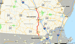
Map of southern New Hampshire with Everett Turnpike highlighted in red | |
| Route information | |
| Maintained by NHDOT Bureau of Turnpikes | |
| Length: | 39.867 mi[1] (64.160 km) |
| Existed: | c. 1955 – present |
| Major junctions | |
| South end: |
|
|
| |
| North end: |
|
| Location | |
| Counties: | Hillsborough, Merrimack |
| Highway system | |

The Frederick E. Everett Turnpike, also called the Central New Hampshire Turnpike, is a toll road in New Hampshire, USA, running 44 miles (71 km) from the Massachusetts border at Nashua north to Concord. The Everett Turnpike is named for Frederick Elwin Everett, the first Commissioner of the New Hampshire Department of Transportation.[2]
The turnpike is part of the New Hampshire Turnpike System, and is operated by the New Hampshire Department of Transportation's Bureau of Turnpikes.
Route description
Much of the turnpike's length has been overlapped by other numbered routes. Portions of the road are shared with US-3, I-93, and I-293. The southern portion of the turnpike, in Nashua, is posted as US-3, serving as an extension of the US-3 freeway (Northwest Expressway) from Burlington, Massachusetts. North of Exit 7 in Nashua, the turnpike runs by itself and has no number, but parallels US-3, which is a toll-free local road variously known as Concord Street (within the city of Nashua) and the Daniel Webster Highway (within Merrimack and Bedford). Approaching Bedford in the Manchester area, the turnpike is joined by I-293 which splits off from a concurrency with NH-101. At Exit 4 (exits are numbered for I-293 on this stretch), NH-3A joins the freeway, and the concurrency passes through Manchester, near the downtown area of the city. Upon passing Manchester, Route 3A splits off at Exit 7, I-293's last northbound exit. The freeway passes into Hooksett, and I-293 ends at an interchange with I-93. The Everett Turnpike ceases to be signed at this interchange, but joins I-93 northbound and continues towards Concord, interchanging with the southern terminus of I-89 along the way. No definitive northern terminus for the turnpike exists as far as signage is concerned. This endpoint was originally at a traffic circle next to downtown Concord that has since been replaced by Exit 14 with NH-9.
There are two mainline toll plazas on the turnpike, in Bedford and Hooksett. The Bedford mainline toll plaza, located between Exit 12 and I-293, replaced the Merrimack toll plaza (formerly located at what is now Exit 11) in the early 1990s. Ramp tolls also exist in Merrimack (at Exits 10 and 11) and Hooksett (the on/off-ramps to I-93 Exit 11/NH-3A). E-ZPass readers were installed in all toll locations in 2005. Major rest areas combined with state-run liquor stores are located on either side of the highway in Hooksett just north of the mainline toll plaza, which is located on I-93 at Exit 11. On July 18, 2014, the Exit 12 ramp tolls in Merrimack were removed.
The proposed (but mostly unbuilt) Circumferential Highway around the east side of Nashua is defined as part of the turnpike.[3] Henri A. Burque Highway, the surface road that US-3 uses to get between exit 7 of the turnpike and the Daniel Webster Highway in northern Nashua, is also part of it.[1]
Signs
Though the Turnpike continues north to Concord, it is not signed north of the I-293 merge in Hooksett. On I-93 North, the exit for I-293 is signed as I-293/Everett Turnpike South, while the mainline is signed as I-93 North (as a toll highway). On I-293 North, Everett Turnpike signs stop at the merge, with I-93 North signed by itself. There is no indication of the northern terminus on I-93 in either direction. The first reassurance of the Turnpike southbound is after the exit onto I-293. There are no indications of the Turnpike on any intersecting highways north of the merge, including I-89.
There are mile posts on the Turnpike only from the Massachusetts state line to the interchange with I-293 and Route 101. North of this interchange, only mileposts of the Interstate highways are posted.
In 2010, the signs were fixed [which means how much, if any, of the above text is now outdated and should be removed? and does "fixed" mean "set in stone" or that the problem was rectified?].
History
Prior to the September 11, 2001 attacks, exit 4 in Nashua was signed as "East Dunstable Road / FAA Center." The "FAA Center" signage was removed at the request of the Federal Aviation Administration.
Exit list
| County | Location | mi[1] | km | Old exit [4][5][3][6][7] | New exit | Destinations | Notes |
|---|---|---|---|---|---|---|---|
| Hillsborough | Nashua | 0.00 | 0.00 | Continuation into Massachusetts | |||
| 0.50 | 0.80 | 1 | Spit Brook Road – South Nashua | ||||
| 1.49 | 2.40 | 2 | Circumferential Highway; signed as exit 1A from northbound collector–distributor lane | ||||
| 2.59 | 4.17 | 1 | 3 | Daniel Webster Highway – South Nashua | Southbound exit and northbound entrance only; originally exit 1 | ||
| 3.18 | 5.12 | 4 | East Dunstable Road | ||||
| 4.69 | 7.55 | 2 | 5 | Signed as exits 5E (east) and 5W (west); originally exit 2 | |||
| 5.13 | 8.26 | 5E-A | 5A | Simon Street | Northbound exit only, formerly signed as Exit 5E-A | ||
| 6.22 | 10.01 | 6 | |||||
| 6.74 | 10.85 | 7 | Northern terminus of US 3 concurrency; signed as exits 7E (east) and 7W (west) | ||||
| 7.66 | 12.33 | 7W | 8 | Locally known as Somerset Parkway | |||
| Merrimack | 9.83 | 15.82 | 10 | Toll barriers on northbound exit and southbound entrance ramps | |||
| 11.10 | 17.86 | 8 | 11 | Toll barriers on northbound exit and southbound entrance ramps | |||
| 14.94 | 24.04 | 12 | Northbound exit and southbound entrance only. No longer tolled. | ||||
| Bedford | 13 | Interchange opened in 2011 | |||||
| Bedford toll plaza | |||||||
| 19.39 | 31.21 | 10 | — | Southern terminus of I-293 concurrency; exit numbers follow I-293; originally exit 5 | |||
| Manchester | 21.22 | 34.15 | 6 | 4 | Southern terminus of NH 3 concurrency | ||
| 21.96 | 35.34 | 5 | Granite Street – West Manchester | ||||
| 23.27 | 37.45 | 7 | 6 | Amoskeag Street, Goffstown Road | Originally exit 7 | ||
| 24.25 | 39.03 | 7 | Northbound exit and southbound entrance only; northern terminus of NH 3A concurrency | ||||
| Merrimack | Hooksett | 27.18 | 43.74 | — | Northern terminus of I-293 concurrency, southern terminus of I-93 concurrency; exit numbers follow I-93 | ||
| Hooksett toll plaza | |||||||
| 29.52 | 47.51 | 8 | 11 | Toll barrier between interchange and NH 3A; originally exit 8 | |||
| Bow | 36.24 | 58.32 | — | Originally exit 9 | |||
| Concord | 36.91 | 59.40 | 12 | Signed as exits 12N (north) and 12S (south) | |||
| 38.08 | 61.28 | 13 | |||||
| 39.20 | 63.09 | 14 | |||||
| Everett Turnpike ends; continuation past NH 9 | |||||||
1.000 mi = 1.609 km; 1.000 km = 0.621 mi
| |||||||
See also
References
- 1 2 3 GRANIT GIS data - NH Public Roads
- ↑ Brown, Janice A. (2006-08-23). "New Hampshire's Turnpike History". Cow Hampshire. BlogHarbor. Retrieved 2009-01-15. External link in
|publisher=, |work=(help) - 1 2 New Hampshire Statutes Title XX Chapter 237
- ↑ 1968 Indiana Toll Road map (has exits 3-10 from Nashua to Milford, then present exits 11-13 from Hooksett to Concord)
- ↑ 1985 USGS topo
- ↑ 1985 USGS topo
- ↑ 1957 USGS Suncook quadrangle