Falls of the Ohio National Wildlife Conservation Area
| Falls of the Ohio National Wildlife Conservation Area | |
|---|---|
|
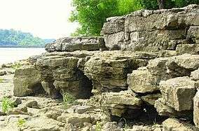
Fossil formations at the shores of the Ohio River in Clarksville | |
| Location | Indiana, Kentucky |
| Nearest city | Louisville, Kentucky |
| Coordinates | 38°16′36″N 85°45′56″W / 38.27665°N 85.76544°WCoordinates: 38°16′36″N 85°45′56″W / 38.27665°N 85.76544°W |
| Established | 1981 |
| Designated | 1966 |
The Falls of the Ohio National Wildlife Conservation Area is a national, bi-state area on the Ohio River near Louisville, Kentucky in the United States, administered by the U.S. Army Corps of Engineers. Federal status was awarded in 1981. The falls were designated a National Natural Landmark in 1966.[1]
Overview
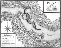
The area is located at the Falls of the Ohio, which was the only navigational barrier on the river in earlier times. The falls were a series of rapids formed by the relatively recent erosion of the Ohio River operating on 386 million-year-old Devonian hard limestone rock shelves. Louisville, Kentucky, and the associated Indiana communities—Jeffersonville, Clarksville, and New Albany—all owe their existence as communities to the falls, as the navigational obstacles the falls presented meant that late 18th-century and early- to late-19th-century river traffic could benefit from local expertise in navigating the 26-foot (7.9 m) drop made by the river over a distance of two miles (3 km). In its original form, the falls could be characterized more as rapids extending over a length of the river, than as a point-like discontinuity in a river such as Niagara Falls. Still, the falls provided a singular, dramatic and daunting obstacle to navigation on this important inland waterway.
The first locks on the river, the Louisville and Portland Canal completed in 1830, were built within a bypass canal constructed to provide year-round navigation of the river. The falls were later largely covered by the McAlpine Locks and Dam, built by the Army Corps of Engineers. The taming of the Ohio River at the falls, with the attendant reduction in local flow velocity has of late led to the covering over of the fossil beds by large and increasing quantities of low-velocity effluvia: although an impediment to viewing of the fossils, this action serves to protect the portions of the falls covered over by sediment and therefore temporarily immune to direct weathering. However, a significant area of the fossil-rich Devonian limestone rock is still left exposed, and is accessible to visitors today. The best time for visitation is during the low water season of the Ohio River between August and October. Removal of fossils is prohibited.
The shallowness of the falls provided a favored crossing point for bison in pre-settlement times and, later, an easy crossing for Native Americans.
In 1990, a section of the area in Indiana became the Falls of the Ohio State Park. An interpretive center is open throughout the year.
Size and sound
Prior to modification, for industrial and navigational purposes, the Falls of the Ohio spanned the entire width of the Ohio River. Native Americans and early European explorers heard the crisp roar of the Ohio River crashing down the cascade falls more than 10 miles away.[2] Ranked by the product of river flow and river width, the Falls of the Ohio is the 7th largest waterfall in the world.
Geology
The rock unit in which the falls are formed is referred to as the Jeffersonville Limestone. The limestone formed approximately 387 to 380 million years ago during the Emsian Age (in the latest part of the Early Devonian Period) and the Eifelian Age (Middle Devonian). The exposure is unique—large and diverse tabulate corals and rugose corals are exposed in lifelike positions. Brachiopods and bryozoans are also present, as are gastropods (snails).
During the Devonian Period, the region lay at the bottom of a shallow inland sea about ten degrees north of the equator in the supercontinent of Euramerica.
See also
- Geography of Louisville, Kentucky
- History of Louisville, Kentucky
- List of attractions and events in the Louisville metropolitan area
References
- ↑ "Ohio Coral Reef (Falls of the Ohio)". nps.gov. National Park Service.
- ↑ http://digicoll.library.wisc.edu/WIReader/Contents/Voyage.html. Missing or empty
|title=(help)
External links
- Falls of the Ohio State Park
- Falls of the Ohio Archaeological Society
- McAlpine Dam (U.S. Army Corps of Engineers)
- Falls of the Ohio ~ Historic Maps
| History |
|  |
|---|---|---|
| Geography |
| |
| Government |
| |
| Transportation | ||
| Other subject areas | ||
| Top subjects | ||
| National Historic Landmarks | ||
| Prominent suburbs (over 10K pop.) | ||
| ||