Louisville metropolitan area
| Louisville metropolitan area | |
|---|---|
| Metropolitan Statistical Area | |
|
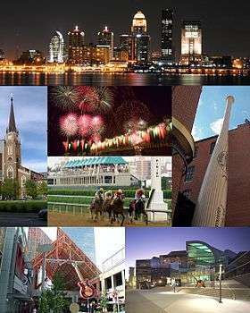
Downtown Louisville skyline | |
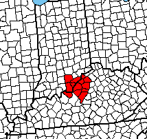 The Louisville MSA (as of 2010 census) from a state-level zoom | |
| Country |
|
| States |
|
| Principal city | Louisville |
| Area | |
| • Urban | 477.2 sq mi (1,236 km2) |
| • MSA | 4,135.4 sq mi (10,711 km2) |
| Population (2015) | |
| • Urban | 1,025,000[1] (US: 43rd[lower-alpha 1]) |
| • Urban density | 2,147.9/sq mi (829.3/km2) |
| • MSA | 1,278,413[2] (US: 43rd[lower-alpha 2]) |
| • CSA | 1,504,559[3] (US: 35th) |
| Time zone | EST (UTC-5) |
| • Summer (DST) | EDT (UTC-4) |

The Louisville/Jefferson County, KY–IN Metropolitan Statistical Area, commonly called the Louisville metropolitan area or Kentuckiana, is the 43rd largest[lower-alpha 2] Metropolitan Statistical Area (MSA) in the United States. The primary city is Louisville, Kentucky.
It was originally formed by the United States Census Bureau in 1950 and consisted of the Kentucky county of Jefferson and the Indiana counties of Clark and Floyd. As surrounding counties saw an increase in their population densities and the number of their residents employed within Jefferson County, they met Census criteria to be added to the MSA. Jefferson County, Kentucky (contiguous with Louisville Metro), plus twelve outlying counties – seven in Kentucky and five in Southern Indiana – are now a part of this MSA. One other Kentucky county was part of the MSA in the 2000 and 2010 U.S. Censuses, but was spun off by the Census Bureau into its own Micropolitan Statistical Area in 2013.
People living in any of the MSA are said to be living in the Louisville/Jefferson County Area. Because it includes counties in Indiana, the MSA (or a large portion thereof) is regularly referred to as Kentuckiana. It is now the primary MSA of the Louisville/Jefferson County–Elizabethtown–Madison, KY–IN Combined Statistical Area (or Louisville CSA, which adds Hardin County, Kentucky, LaRue County, Kentucky, Jefferson County, Indiana, and Nelson County, Kentucky). The combined statistical area created by the United States Bureau of the Census in 2000 and most recently redefined in 2013 comprises the Louisville/Jefferson County, KY–IN Metropolitan Statistical Area (MSA), the Elizabethtown-Fort Knox, KY Metropolitan Statistical Area, the Bardstown, KY Micropolitan Statistical Area and the Madison, IN Micropolitan Statistical Area (also abbreviated as MSA).
Definitions
As of 2013 the U.S. Office of Management and Budget defines the Louisville/Jefferson County, KY-IN Metropolitan Statistical Area as including Bullitt, Henry, Jefferson, Meade, Oldham, Shelby, and Trimble Counties in Kentucky and Clark, Floyd, Harrison, Scott, and Washington Counties in Indiana. The larger Louisville/Jefferson County–Elizabethtown–Madison, KY–IN Combined Statistical Area adds two other statistical areas in Kentucky and one in Indiana:
- The Elizabethtown–Fort Knox, KY Metropolitan Statistical Area, consisting of Hardin and LaRue Counties.
- The Bardstown, KY Micropolitan Statistical Area, consisting of Nelson County.
- The Madison, IN Micropolitan Statistical Area, consisting of that state's Jefferson County.
Counties
Louisville/Jefferson County, KY-IN MSA
- Bullitt County, KY (77,995)
- Clark County, IN (114,262)
- Floyd County, IN (76,179)
- Harrison County, IN (39,299)
- Henry County, KY (15,572)
- Jefferson County, KY (760,026)
- Meade County, KY (29,139)
- Oldham County, KY (63,490)
- Scott County, IN (24,181)
- Shelby County, KY (44,875)
- Spencer County, KY (17,668)
- Trimble County, KY (8,786)
- Washington County, IN (27,878)
Elizabethtown–Fort Knox, KY MSA
- Hardin County, KY (108,266)
- LaRue County, KY (14,180)
Bardstown, KY µSA
- Nelson County, KY (44,812)
Madison, IN µSA
- Jefferson County, IN (32,494)
Municipalities
Principal city
In 2003, the Jefferson government merged with that of its largest city and county seat, Louisville, forming a new entity, the Louisville/Jefferson County Metro Government (official long form) or Louisville Metro (official short form). All small cities within Jefferson became part of the new Louisville Metro government while retaining their city governments. For statistical and ranking purposes, the United States Census Bureau uses the statistical entity Louisville/Jefferson County (balance), Kentucky to represent the portion of the consolidated city-county of Louisville/Jefferson County that does not include any of the 83 separate incorporated places (municipalities) located within the city and county.
Louisville Metro (756,832)
Louisville/Jefferson County (balance) (609,893)
Municipalities with more than 25,000 people
Municipalities with 10,000 to 25,000 people
- Clarksville, IN
- Lyndon, KY*
- Mount Washington, KY
- St. Matthews, KY*
- Shelbyville, KY
- Shepherdsville, KY
- Shively, KY*
Municipalities with less than 10,000 people
- Anchorage*
- Audubon Park*
- Bancroft*
- Barbourmeade*
- Beechwood Village*
- Bellemeade*
- Bellewood*
- Blue Ridge Manor*
- Borden
- Brandenburg
- Briarwood*
- Broeck Pointe*
- Brownsboro Farm*
- Brownsboro Village*
- Cambridge*
- Campbellsburg
- Charlestown
- Clarksville
- Coldstream*
- Corydon
- Crandall
- Creekside*
- Crestwood
- Crossgate*
- Douglass Hills*
- Druid Hills*
- Ekron
- Elizabeth
- Eminence
- Fincastle*
- Forest Hills*
- Fox Chase
- Fredericksburg
- Georgetown
- Glenview Hills*
- Glenview Manor*
- Glenview*
- Goose Creek*
- Goshen
- Graymoor-Devondale*
- Green Spring*
- Greenville
- Hardinsburg
- Hebron Estates
- Heritage Creek*
- Hickory Hill*
- Hills and Dales*
- Hillview
- Hollow Creek*
- Hollyvilla*
- Houston Acres*
- Hunters Hollow
- Hurstbourne Acres*
- Hurstbourne*
- Indian Hills*
- Kingsley*
- La Grange
- Laconia
- Lanesville
- Langdon Place*
- Lebanon Junction
- Lincolnshire*
- Little York
- Livonia
- Lynnview*
- Manor Creek*
- Maryhill Estates*
- Mauckport
- Meadow Vale*
- Meadowbrook Farm*
- Meadowview Estates*
- Middletown*
- Milltown
- Mockingbird Valley*
- Moorland*
- Muldraugh
- Murray Hill*
- New Amsterdam
- New Castle
- New Middletown
- New Pekin
- Norbourne Estates*
- Northfield*
- Norwood*
- Old Brownsboro Place*
- Orchard Grass Hills
- Palmyra
- Parkway Village*
- Pewee Valley
- Pioneer Village
- Plantation*
- Pleasureville
- Poplar Hills*
- Prospect*‡
- Richlawn*
- River Bluff
- Riverwood*
- Rolling Fields*
- Rolling Hills*
- Saltillo
- Sellersburg
- Seneca Gardens*
- Simpsonville
- Smithfield
- South Park View*
- Spring Mill*
- Spring Valley*
- St. Regis Park*
- Strathmoor Manor*
- Strathmoor Village*
- Sycamore*
- Taylorsville
- Ten Broeck*
- Thornhill*
- Utica
- Vine Grove
- Watterson Park*
- Wellington*
- West Buechel*
- Westwood*
- Wildwood*
- Windy Hills*
- Woodland Hills*
- Woodlawn Park*
- Worthington Hills*
*Part of Louisville Metro
‡Prospect lies in both Jefferson and Oldham Counties. The portion within Jefferson County is part of Louisville Metro.
Historical statistics
Metropolitan Statistical Area
| Geographic Area | 2010 Census | 2000 Census | 1990 Census | 1980 Census | 1970 Census | 1960 Census | 1950 Census |
|---|---|---|---|---|---|---|---|
| Louisville/Jefferson County, KY-IN MSA[m 1] | 1,307,647 | 1,161,975 | 952,662 | 906,152 | 867,330 | 725,139 | 576,900 |
| Clark County, Indiana | 110,232 | 96,472 | 87,777 | 88,838 | 75,876 | 62,795 | 48,330 |
| Floyd County, Indiana | 74,478 | 70,823 | 64,404 | 61,169 | 55,622 | 51,397 | 43,955 |
| Harrison County, Indiana | 39,364 | 34,325 | 29,890 | 27,276[m 2] | 20,423[m 2] | 19,207[m 2] | 17,858[m 2] |
| Scott County, Indiana | 24,181[m 2] | 22,960 | 20,991[m 2] | 20,422[m 2] | 17,144[m 2] | 14,463[m 2] | 11,519[m 2] |
| Washington County, Indiana | 28,262 | 27,223 | 23,717[m 2] | 21,932[m 2] | 19,278[m 2] | 17,819[m 2] | 16,520[m 2] |
| Bullitt County, Kentucky | 74,319 | 61,236 | 47,567 | 43,346 | 26,090 | 15,726[m 2] | 11,349[m 2] |
| Henry County, Kentucky | 15,416 | 15,060 | 12,823[m 2] | 12,740[m 2] | 10,910[m 2] | 10,987[m 2] | 11,394[m 2] |
| Jefferson County, Kentucky | 741,096 | 693,604 | 664,937 | 685,004 | 695,055 | 610,947 | 484,615 |
| Meade County, Kentucky | 28,602 | 26,349 | 24,170[m 2] | 22,854[m 2] | 17,796[m 2] | 18,898[m 2] | 9,422[m 2] |
| Nelson County, Kentucky[m 3] | 43,437 | 37,477 | 29,710[m 2] | 27,584[m 2] | 23,477[m 2] | 22,168[m 2] | 19,521[m 2] |
| Oldham County, Kentucky | 60,316 | 46,178 | 33,263 | 27,795 | 14,687 | 13,388[m 2] | 11,018[m 2] |
| Shelby County, Kentucky | 42,074 | 33,337 | 24,824 | 23,328[m 2] | 18,999[m 2] | 18,493[m 2] | 17,912[m 2] |
| Spencer County, Kentucky | 17,061 | 11,766 | 6,801[m 2] | 5,929[m 2] | 5,488[m 2] | 5,680[m 2] | 6,157[m 2] |
| Trimble County, Kentucky | 8,809 | 8,125 | 6,090[m 2] | 6,253[m 2] | 5,349[m 2] | 5,102[m 2] | 5,148[m 2] |
Notes
- Populations are based upon published estimates by the United States Bureau of the Census.
- ↑ Named Louisville, KY-IN Standard Metropolitan Area (SMA) in 1950, Louisville, KY-IN Standard Metropolitan Statistical Area (SMSA) from 1960 to 1981, and Louisville, KY-IN Metropolitan Statistical Area (MSA) from 1983 to 2003.
- 1 2 3 4 5 6 7 8 9 10 11 12 13 14 15 16 17 18 19 20 21 22 23 24 25 26 27 28 29 30 31 32 33 34 35 36 37 38 39 40 41 42 43 44 45 46 47 48 County was not a part of Louisville, KY-IN MSA at the time of this Census and the county's population is not included in MSA total.
- ↑ County is no longer included in the MSA as of 2016.
Combined Statistical Area
| Geographic Area | 2010 Census | 2000 Census | 1990 Census |
|---|---|---|---|
| Louisville/Jefferson County–Elizabethtown–Madison, KY-IN CSA[c 1] | 1,451,564 | 1,292,482 | 1,177,883[c 2] |
| Louisville/Jefferson County, KY-IN MSA | 1,307,647 | 1,161,975 | 952,662 |
| Clark County, Indiana | 110,232 | 96,472 | 87,777 |
| Floyd County, Indiana | 74,478 | 70,823 | 64,404 |
| Harrison County, Indiana | 39,364 | 34,325 | 29,890 |
| Washington County, Indiana | 28,262 | 27,223 | 23,717[c 3] |
| Bullitt County, Kentucky | 74,319 | 61,236 | 47,567 |
| Henry County, Kentucky | 15,416 | 15,060 | 12,823[c 3] |
| Jefferson County, Kentucky | 741,096 | 693,604 | 664,937 |
| Meade County, Kentucky | 28,602 | 26,349 | 24,170[c 3] |
| Oldham County, Kentucky | 60,316 | 46,178 | 33,263 |
| Shelby County, Kentucky | 42,074 | 33,337 | 24,824 |
| Spencer County, Kentucky | 17,061 | 11,766 | 6,801[c 3] |
| Trimble County, Kentucky | 8,809 | 8,125 | 6,090[c 3] |
| Elizabethtown–Fort Knox, KY MSA[c 4] | 119,736 | 107,547 | 100,919[c 2] |
| Hardin County, Kentucky | 105,543 | 94,174 | 89,240 |
| LaRue County, Kentucky | 14,193 | 13,373 | 11,679 |
| Bardstown, KY µSA | 43,437 | 37,477 | 29,710[c 3] |
| Nelson County, Kentucky | 43,437[c 5] | 37,477[c 5] | 29,710[c 3] |
| Madison, IN µSA | 32,458 | 32,428[c 2] | 32,000[c 2] |
| Jefferson County, Indiana | 32,458 | 32,428 | 32,000 |
Notes
- Populations are based upon published estimates by the United States Bureau of the Census.
- ↑ Named Louisville–Elizabethtown–Scottsburg, KY-IN CSA from 2000 to 2003, and Louisville/Jefferson County–Elizabethtown–Scottsburg, KY-IN CSA from 2003 to 2013.
- 1 2 3 4 Census defined area did not exist during this Census. Population totals are for counties included in 2000 Census MSA or CSA estimates. Population is shown for comparison purposes only and should not be used as a reference.
- 1 2 3 4 5 6 7 County was not a part of Louisville, KY-IN MSA at the time of this Census and the county's population is not included in MSA total.
- ↑ Named Elizabethtown, KY MSA from 2000 to 2013.
- 1 2 This county was part of the Louisville MSA in the 2000 and 2010 Censuses, but has since been spun off into its own statistical area. Its population is included in the MSA total for those censuses.
See also
Notes
- ↑ 2010 data
- 1 2 The United States MSA table excludes the San Juan, Puerto Rico MSA which has a higher population than Louisville.
References
- ↑ Demographia (January 2015). Demographia World Urban Areas (PDF) (11th ed.). Retrieved April 5, 2016
- ↑ "Annual Estimates of the Resident Population: April 1, 2010 to July 1, 2015". United States Census Bureau. U.S. Census Bureau, Population Division. March 2016. Retrieved April 5, 2016.
- ↑ "Table 1. Annual Estimates of the Resident Population: April 1, 2010 to July 1, 2015 – United States – Combined Statistical Area; and for Puerto Rico". 2015 Population Estimates. United States Census Bureau, Population Division. March 2016. Retrieved April 5, 2016.
External links
- Louisville metropolitan area at DMOZ
- U.S. Census Bureau State & County QuickFacts
- U.S. Census Bureau population estimates
- Metropolitan and Micropolitan Statistical Areas
- About Metropolitan and Micropolitan Statistical Areas
- Metropolitan Area Standards Review Project (MASRP)
Coordinates: 38°13′44″N 85°44′58″W / 38.22889°N 85.74944°W
| History |
|  |
|---|---|---|
| Geography |
| |
| Government |
| |
| Transportation | ||
| Other subject areas | ||
| Top subjects | ||
| National Historic Landmarks | ||
| Prominent suburbs (over 10K pop.) | ||
| ||

