Farnay
| Farnay | |
|---|---|
|
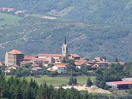
The church and surrounding buildings in Farnay | |
 Farnay | |
|
Location within Auvergne-Rhône-Alpes region  Farnay | |
| Coordinates: 45°29′39″N 4°35′55″E / 45.4942°N 4.5986°ECoordinates: 45°29′39″N 4°35′55″E / 45.4942°N 4.5986°E | |
| Country | France |
| Region | Auvergne-Rhône-Alpes |
| Department | Loire |
| Arrondissement | Saint-Étienne |
| Canton | La Grand-Croix |
| Intercommunality | Communauté d'agglomération Saint-Étienne Métropole |
| Government | |
| • Mayor (2008–2014) | Gérard Couturier (PR) |
| Area1 | 7.93 km2 (3.06 sq mi) |
| Population (1999)2 | 1,139 |
| • Density | 140/km2 (370/sq mi) |
| Time zone | CET (UTC+1) |
| • Summer (DST) | CEST (UTC+2) |
| INSEE/Postal code | 42093 / 42320 |
| Elevation |
315–792 m (1,033–2,598 ft) (avg. 445 m or 1,460 ft) |
|
1 French Land Register data, which excludes lakes, ponds, glaciers > 1 km² (0.386 sq mi or 247 acres) and river estuaries. 2 Population without double counting: residents of multiple communes (e.g., students and military personnel) only counted once. | |
Farnay is a commune in the Loire department in central France.
See also
| Wikimedia Commons has media related to Farnay. |
This article is issued from Wikipedia - version of the 10/28/2016. The text is available under the Creative Commons Attribution/Share Alike but additional terms may apply for the media files.