Villars, Loire
| Villars | ||
|---|---|---|
|
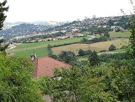
A general view of Villars | ||
| ||
 Villars | ||
|
Location within Auvergne-Rhône-Alpes region  Villars | ||
| Coordinates: 45°28′11″N 4°21′19″E / 45.4697°N 4.3553°ECoordinates: 45°28′11″N 4°21′19″E / 45.4697°N 4.3553°E | ||
| Country | France | |
| Region | Auvergne-Rhône-Alpes | |
| Department | Loire | |
| Arrondissement | Saint-Étienne | |
| Canton | Saint-Étienne-Nord-Ouest-1 | |
| Intercommunality | Communauté d'agglomération Saint-Étienne Métropole | |
| Government | ||
| • Mayor (2008–2014) | M. Paul Celle | |
| Area1 | 5.72 km2 (2.21 sq mi) | |
| Population (2006)2 | 8,686 | |
| • Density | 1,500/km2 (3,900/sq mi) | |
| Time zone | CET (UTC+1) | |
| • Summer (DST) | CEST (UTC+2) | |
| INSEE/Postal code | 42330 / 42390 | |
| Elevation |
428–600 m (1,404–1,969 ft) (avg. 480 m or 1,570 ft) | |
|
1 French Land Register data, which excludes lakes, ponds, glaciers > 1 km² (0.386 sq mi or 247 acres) and river estuaries. 2 Population without double counting: residents of multiple communes (e.g., students and military personnel) only counted once. | ||
.svg.png)
Villars is a commune in the Loire department in central France.
Villars is a former mining town.
Twin towns
 Halberstadt, Germany, since 15 November 2003
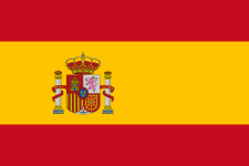 Torredembarra, Spain, since 2 September 1984
See also
| Wikimedia Commons has media related to Villars (Loire). |
This article is issued from Wikipedia - version of the 10/28/2016. The text is available under the Creative Commons Attribution/Share Alike but additional terms may apply for the media files.