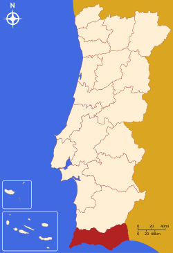
Faro District
| Faro District | |
|---|---|
| District | |
 | |
| Country | Portugal |
| Region | Algarve |
| Historical province | Algarve |
| No. of municipalities | 16 |
| No. of parishes | 84 |
| Capital | Faro |
| Area | |
| • Total | 4,960 km2 (1,920 sq mi) |
| Population | |
| • Total | 458,734 |
| • Density | 92/km2 (240/sq mi) |
| No. of parliamentary representatives | 9 |
Faro District (Portuguese pronunciation: [ˈfaɾu], Portuguese: Distrito de Faro) is the southernmost district of Portugal, coincident with the Algarve. The administrative centre, or capital, is the city of Faro.
Municipalities
The district is composed of 16 municipalities:
- Albufeira
- Alcoutim
- Aljezur
- Castro Marim
- Faro
- Lagoa
- Lagos
- Loulé
- Monchique
- Olhão
- Portimão
- São Brás de Alportel
- Silves
- Tavira
- Vila do Bispo
- Vila Real de Santo António
Palácio de Estói: garden with Baroque gate,
Estoi, Faro District.
Estoi, Faro District.
See also
| Wikimedia Commons has media related to Faro (district). |
- Faro, Portugal
- Algarve
 Media related to Buildings in Faro (district) at Wikimedia Commons
Summary of votes and seats won 1976-2011
Summary of election results from Faro district, 1976-2011
| Parties | % | S | % | S | % | S | % | S | % | S | % | S | % | S | % | S | % | S | % | S | % | S | % | S | % | S |
|---|---|---|---|---|---|---|---|---|---|---|---|---|---|---|---|---|---|---|---|---|---|---|---|---|---|---|
| 1976 | 1979 | 1980 | 1983 | 1985 | 1987 | 1991 | 1995 | 1999 | 2002 | 2005 | 2009 | 2011 | ||||||||||||||
| PS | 44.6 | 6 | 34.0 | 3 | 34.7 | 4 | 43.2 | 5 | 22.3 | 2 | 24.9 | 3 | 31.2 | 3 | 49.6 | 5 | 48.4 | 5 | 40.5 | 4 | 49.3 | 6 | 31.9 | 3 | 23.0 | 2 |
| PSD | 19.3 | 2 | 23.1 | 2 | 28.4 | 3 | 46.7 | 5 | 50.8 | 5 | 29.2 | 3 | 29.5 | 3 | 37.7 | 4 | 24.6 | 2 | 26.2 | 3 | 37.0 | 4 | ||||
| CDS-PP | 6.8 | 7.4 | 6.1 | 3.1 | 2.8 | 8.3 | 7.3 | 8.3 | 5.8 | 10.7 | 1 | 12.7 | 1 | |||||||||||||
| PCP/APU/CDU | 14.5 | 1 | 20.3 | 2 | 16.7 | 1 | 18.6 | 2 | 15.4 | 2 | 10.9 | 1 | 7.2 | 7.8 | 8.3 | 6.3 | 6.9 | 7.8 | 8.6 | 1 | ||||||
| BE | 2.3 | 2.8 | 7.7 | 15.3 | 1 | 8.2 | 1 | |||||||||||||||||||
| AD | 34.6 | 4 | 37.2 | 4 | ||||||||||||||||||||||
| PRD | 20.5 | 2 | 6.3 | |||||||||||||||||||||||
| Source: Comissão Nacional de Eleições | ||||||||||||||||||||||||||
Coordinates: 37°00′54″N 7°56′06″W / 37.01500°N 7.93500°W
This article is issued from Wikipedia - version of the 9/16/2015. The text is available under the Creative Commons Attribution/Share Alike but additional terms may apply for the media files.