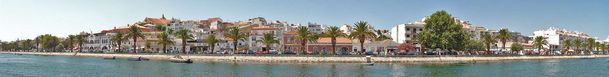
Lagos, Portugal
| Lagos | |||
|---|---|---|---|
| Municipality | |||
|
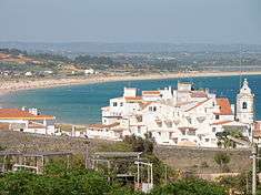
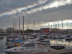
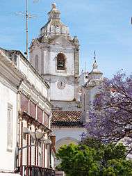
Lagos in early-June 2011 | |||
| |||
 | |||
| Coordinates: 37°6′10″N 8°40′22″W / 37.10278°N 8.67278°WCoordinates: 37°6′10″N 8°40′22″W / 37.10278°N 8.67278°W | |||
| Country |
| ||
| Region | Algarve | ||
| Subregion | Algarve | ||
| Intermunic. comm. | Algarve | ||
| District | Faro | ||
| Parishes | 4 | ||
| Government | |||
| • President | Júlio José Monteiro Barroso (PS) | ||
| Area | |||
| • Total | 212.99 km2 (82.24 sq mi) | ||
| Population (2011) | |||
| • Total | 31,049 | ||
| • Density | 150/km2 (380/sq mi) | ||
| Time zone | WET/WEST (UTC+0/+1) | ||
| Postal code | 8600 | ||
| Area code | 282 | ||
| Website | http://www.cm-lagos.pt | ||

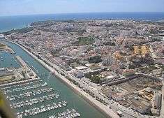
Lagos (Portuguese pronunciation: [ˈlaɣuʃ], literally lakes, from the Latin lacobrica) is a municipality at the mouth of Bensafrim River and along the Atlantic Ocean, in the Barlavento region of the Algarve, in southern Portugal.[1] The population in 2011 was 31,049,[2] in an area of 212.99 km².[3] The main town of Lagos (which includes only the parish of São Sebastião e Santa Maria) has a population of approximately 22,000.[4] Typically, these numbers increase during the summer months, with the influx of visiting tourists and seasonal residents. While the majority of the population lives along the coast and works in tourism and services, the inland region is sparsely inhabited, with the majority of the people working in agriculture and forestry.
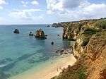
Lagos is one of the most visited cities in the Algarve and Portugal, due to its variety of tourist-friendly beaches, rock formations (Ponta da Piedade), bars, restaurants and hotels, renowned for its vibrant summer nightlife and parties. Yet, Lagos is also a historic centre of the Portuguese Age of Discovery, frequent home of Henry the Navigator, historical shipyard and, at one time, centre of the European slave trade.[5] In 2012, travel website TripAdvisor, classified Lagos as the number 1 travel destination, on a list of "15 destinations on the rise" worldwide.[6]
History

Lagos is an ancient maritime town with more than 2000 years of history. The name Lagos comes from a Celtic settlement, derived from the Latin Lacobriga, the name of the settlement was established during the pre-Punic civilizations. It became an early settlement of the Carthaginians, who recruited Celtic tribesmen in their war against the Romans (the Punic Wars). Owing to its already important harbour, it was colonized by the Romans and integrated into the Roman province of Lusitania, becoming known as Lacobriga. Quintus Sertorius, a rebellious Roman general, helped by the Lusitanians of Lacobriga (who had been oppressed under Roman Generals and members of Lucius Cornelius Sulla party), successfully defeated the Roman army of Caecilius Metellus Pius probably at nearby Monte Molião.
With the fall of Rome, the town of Lagos was occupied in the 6th century by the Visigoths from the Kingdom of Toledo and later by the Byzantines.
The Moors arrived in the 8th century from North Africa, renaming the settlement Zawaia (meaning lago, or lake). It became part of the much larger coastal region of al-Gharb, which eventually became known as the algarve. The Moors fortified the town with Lagos Castle and established important trade links to Northern Africa from their bases in the Iberian peninsula. In 1174, the local Wāli gave permission for the Christian peoples to construct a church dedicated to São João Baptista, which was built outside the town's walls (becoming the oldest church in the Algarve).
Kingdom
Even as King Afonso Henriques advanced to the south, the Christian Reconquista never made it into Algarve and Alentejo, and remained under Moorish control. King Sancho I, with the support of Crusader forces used Lagos as a stepping stone to attack the fortress of Alvôr.[7] Zawaia was eventually captured by King Afonso III of Portugal in 1241, but was only taken definitively in 1249. From this period on the King began self-styling himself as the "King of Portugal and the Algarve", stressing the fact that the Algarve (which had for so long been ruled by the Moors as a foreign country) had been annexed into the dominion of the Portuguese. Lagos became an independent jurisdiction under the rule of King Peter I in 1361.
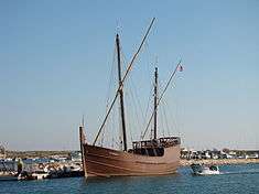
King John I assembled his fleet in the harbour of Lagos, before setting sail for the siege and conquest of the city of Ceuta in 1415. This was the first step in opening the Muslim world to medieval Europe, which in fact led to the Age of Discovery with Portuguese explorers sailing across the whole world. By the 15th century, Lagos became the centre of Portuguese maritime exploration, with ships ordered south to trace the shoreline of Africa in order to find routes to India. Infante Henry the Navigator, third son of King John, lived most of the time in Lagos. From here he directed expeditions to Morocco and to the western coast of Africa with caravels, lateen-rigged ships with excellent seafaring capabilities. Lagos was also the home port for Gil Eanes who was the first to sail beyond Cape Bojador in 1434, after a failed attempt in 1433 that put him out of favour with the, then considered the end of the world. The act of rounding the Cape, much like the later rounding of the Cape of Good Hope, permitted Eanes (and the navigators that followed) to advance into the African subcontinent. When, by 1443, Lançarote (then fiscal officer of the crown) had sailed as far as Arguim and brought back 275 Africans, the Portuguese had sufficient slaves to relieve the perpetual handicap of agricultural labour.[8]
Over the following decades, news of discoveries and achievements, and ships loaded with spices and goods would flow into the port of Lagos. It was also the gateway for the first African slaves into post-medieval Europe.[9] Even before Africa was opened-up to the Portuguese, the seamen of Lagos were already enthusiastic slave-catchers.[10] From the first slave markets in Lagos (the Mercado de Escravos, which opened in 1444), many Africans were dispersed throughout Europe, bringing a considerable income to the Portuguese monarchy and merchant classes, as well as cheap labour force.[9] As the major sponsor of these expeditions, Prince Henry received one-fifth of the selling price of every slave. The demand for the indentured labour force was so high that, by 1450, profit on Mauritanian slaves was 700 percent.[11] The discovery of gold by Alfonso Gonçales also increased activities in Lagos, whose residents petitioned the Infante Henry to establish a trading company to pursue gold deposits in the region.[12] This included Juan Dias (ancestor of Bartolomeu Dias who rounded the Cape of Good Hope), Gil Eanes, Lançarote de Freitas, Estevan Alfonso and Rodrigo Alvarez, who provisioned a squadron of six caravels to travel to isle of Garças in 1444, but returned with 150 Africans.[12]

Following the death of Prince Henry, and the expansion into the Atlantic and New World, the port of Lagos continued to receive shipments of goods and slaves, but its role began to decrease. Lisbon, began to prosper, with ships returning directly from the colonies of the Azores, Madeira and Brazil, while trading houses began to relocate to the capital. But, even as the wealth arrived in Lisbon and Lagos, the ostentation was widely on display in the royal residences.[13]
King Sebastian, obsessed with his plans for a great crusade against the Kingdom of Fez, assembled a huge fleet in Lagos in 1578.[14] During this ill-fated attempt he and most of Portugal's nobility were killed in the Battle of Ksar El Kebir in Morocco, eventually causing a succession crisis, that eventually resulted in the Iberian Union.
When Portugal came under Spanish rule, the Portuguese coast became a target for the English fleet. Lagos, close to the Spanish naval base of Cádiz, was attacked by Sir Francis Drake in the late 1580s, but was defended by its inhabitants, resulting in Drakes sack of Faro.[15] But, the coast was under regular attack of other pirates and corsairs, in addition to the Spanish who bombarded the Algarve during the Portuguese Restoration War (1640–1668), which led to the construction of a string of forts all along the coast. One of them was the late-17th-century Ponta da Bandeira Fort in Lagos, which was completed between 1679 and 1690 (according to the stone inscription over the main door).
From 1576 to 1755, Lagos was a high-profile capital of the Algarve, until the old Portuguese town was destroyed by the earthquake and tsunami of 1755. Although some walls from the 16th century still remain, as well as the governor's castle, many of the buildings are from the 17th century.
Two well-known naval battles took place off Lagos, reflecting its strategic location: in the Battle of Lagos (1693) a French flotilla defeated a combined Anglo-Dutch force, while in the Battle of Lagos (1759) a British force defeated a French force.
Geography

Physical geography
By its geographical position (east-northeast to west-southwest orientation) and lithological diversity, the Algarve stands out as a unique stratigraphic and morpho-tectonic region.[16] A peripheral Carboniferous unit of the Variscan orogeny, it constitutes the Mesozoic and Cenozoic sedimentary layers, deposited onto two totally distinct superimposed basins.[16] Between the Middle-Upper Triassic to Hettangian, sediments evolved from continental (fluvial red sandstone) to shallow marine over the entire region, which included instances of evaporates, tholeiite fissural magmas, lava flows, volcanic ash and pyroclasts.[16]
The area of Lagos, conforms to the Middle Miocene Lagos-Portimão formation (a band that extends along the coast from Lagos to Albufeira, abutting the Serra do Caldeirão to the north) and which corresponds to marine sedimentation over relatively stable, but a minorly deformed limestone shelf platform.[16][17][18] A period of calm during the intra-Miocene (of approximately 2.4 Ma) led to generalized exposure and development of karst, that influences the present day coastline.[16][18] The conspicuous horizontal bending of this profile in the cliffs of Lagos, much like the remainder of the Lagos-Portimão formation, is formed by alternating bands of siliciclastic and calcareous lithologies.[17] The low degree of cementation in the layers causes a high degree of instability of the cliffs.[17] The littoral and cliff sands are dominated by various bivalve organisms, bryozoans, larger benthic foraminifers and Coralline algaewith minor additions of echinoids and balanids implying a shallow-water depositional system of a warm-temperate climatic regime.[17] The locality of Cerro das Mós, from where a large crocodilian (Tomistoma schlegelii) tooth was collected long ago,[19] has also produced some Odontoceti teeth. These may be dated from the Serravallian, which, constitute the oldest marine mammal occurrence in Algarve.[18][20]
Ecoregions/Protected areas
Lagos has many natural interest sites, including:
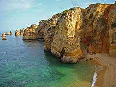
- Ponta da Piedade (English: Mercy Point)
- Grutas da Costa d'Oiro (English: Golden Coast Grottos)
- Laguna de Alvor (English: Lagoon of Alvor)
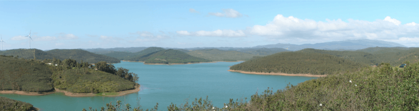
- "Bravura Dam" English: Bravura Dam)
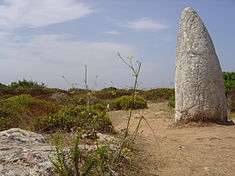
- Mata Nacional de Barão de S.João (English: National Forest of the Baron of Saint John), representing a varied flora that includes Pine (Pinaceae), Acacia (Acacia), Eucalyptus (Eucalyptus) and Strawberry trees (Arbutus unedo), with six pedestrian trails and six campsites. In the zone of Pedra Branca, is a Paleolithic menhir, called the Menhir of Pedro do Galo, accessible through the pedestrian trails, visitors can use the tables and picniking areas near the guardhouse for barbecues, while small children have access to a playground. A public sports field and 100 metre interval obstacle course was also constructed to attract activity, near the picnic area.
Beaches
- Meia Praia (Half Beach) —the most popular tourist beach, consisting of soft, white sand, Meia Praia is one of the largest open bays in Europe, resulting in calm seas, permitting conditions for many nautical sports, while cliffs provide sheltered coves from strong windy conditions;
- Praia Solaria (Sunny Beach);
- Praia da Batata (Potato Beach) — a small beach tucked between two small cliffs (where the river meets the Atlantic Ocean), it is known for the small music festivals that take place there during summer;
- Praia dos Estudantes (Students' Beach);
- Praia da Dona Ana (Dona Ana Beach) -its areal is slightly thicker than the beaches in the surrounding area and it is surrounded by striking rock formations. At high tide the beach is split by the geomorphology of the cliffs;
- Praia do Canavial (Canavial Beach);
- Praia de Camilo (Camilo Beach);
- Praia da Luz (Beach of Light) - located in the parish of Luz, the beach is bounded in the east by Rocha Negra (English: Black Rock), providing summer vactioners with a popular escape during the summer.
Sustainable tourism
In 2012 Lagos received the QualityCoast Gold Award for its efforts to become a sustainable tourism destination. Because of this award, Lagos has been selected for inclusion in the global atlas for sustainable tourism DestiNet. [21]
Human geography
The municipality of Lagos is located approximately 35 kilometres (22 miles) east of the Cape St. Vincent coast, along the southern coast of the Algarve. It is surrounded along its borders by the municipalities of Vila do Bispo (to the west), Aljezur (to the northwest), Monchique (to the northeast) and Portimão (to the east).
To the north of Lagos is the road to Silves, the first capital of Algarve, Monchique (spa town/mountain), Milfontes, a coastal town and port/harbour of the city of Sines, that winds through the scenic protected landscape of the Southwest Natural Park (Costa Sudoeste Alentejana e Vicentina).
|
|
Administratively, the municipality is divided into 4 civil parishes (freguesias):[22]
- Bensafrim e Barão de São João
- Lagos (São Sebastião e Santa Maria)
- Luz which includes the separate villages of Almádena and Espiche.
- Odiáxere
Twin towns — Sister cities
Lagos is twinned with:
 Torres Vedras, district of Lisbon, Portugal
 Ribeira Grande, island of São Miguel, Azores
 Ribeira Grande de Santiago, island of Santiago, Cape Verde
 Palos de la Frontera, autonomous community of Andalusia, Spain
Economy
Lagos' economy, like many coastal towns in Portugal, has always been closely linked to the sea, and fishing has been an important activity since very ancient times. Since 1960, the city has embraced tourism, which has become its most important economic activity. It has beautiful beaches, good climate, the sea, a scenic coastline, and historical patrimony.
The Marina de Lagos has 460 berths and has become an important centre for long-distance cruisers, and it is also known for its modern drawbridge.
Lagos also has numerous cultural and night-life entertainment venues.
Lagos Station is the western terminus of the railway line from Vila Real de Santo António (via Tavira and Faro). The passenger train service is operated by Comboios de Portugal (CP). Connections are available at Faro for trains to Lisbon and Porto.
Architecture
Prehistoric
- Menhir of Cabeço do Rochedo (Portuguese: Menir da Cabeço do Rocheado)
Civic
- Barracks of the Guarda Fiscal of Lagos (Portuguese: Quartel e Posto da Guarda Fiscal)
- Building of the Caixa Geral de Depósitos (Portuguese: Edifício da Caixa Geral de Depositos)
- Building of the Correios, Telégrafos e Telefonos (Portuguese: Edifício dos Correios, Telégrafos e Telefones de Lagos)
- Building of the Portagem (Portuguese: Edifício Antigo da Portagem)
- District Courthouse/Palace of Justice (Portuguese: Tribunal da Comarca/Palácio da Justiça)
- District Jailhouse of Lagos/Cultural Centre of Lagos (Portuguese: Cadeia Comarcã de Lagos/Centro Cultural)
- D. Maria Bridge (Portuguese: Ponte Dona Maria)
- Fonte Coberta Dam (Portuguese: Barragem da Fonte Coberta)
- Gil Eanes Secondary/Commercial-Industrial School (Portuguese: Escola Industrial e Comercial de Lagos/Escola Secundária Gil Eanes)
- Hotel Tivolli Lagos (Portuguese: Hotel de Lagos)
- Municipal Hall of Lagos (Portuguese: Edifício dos Paços do Concelho)
- Lighthouse of Ponta da Piedade (Portuguese: Farol da Ponta da Piedade)
- Pillory of Lagos (Portuguese: Pelourinho de Lagos)
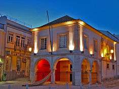
- Regional Museum of Lagos (Portuguese: Museu Regional de Lagos) - this modest regional museum is located next to the church of Santo António.,[23] housing the eclectic collection of archaeological finds from prehistory and the Neolithic, in addition to minerals, Roman mosaics, Moorish oil-lamps and pottery. The ethnographic section includes exhibits from life in the Algarve, that includes not only residential, but also military artefacts, such as swords, muskets and cannonballs, and the foral (charter) issued by King Manuel for Lagos. Religious artefacts are also prominent in the displays, that include the sacerdotal vestments worn by the canons who said Holy Mass to King Sebastian (before he left on his ill-fated conquest of Morocco), and a diptych (dating from the 16th century) with scenes from the Annunciation and Presentation of Jesus at the Temple.
- Slave Market/Customshoues of Lagos (Portuguese: Mercado de Escravos/Vedoria/Alfândega de Lagos)
Military
- Bulwark of Alcaria/Freiras (Portuguese: Baluarte da Alcaria/das Freiras)
- Bulwark of Porta dos Quartos (Portuguese: Baluarte da Porta dos Quartos)
- Bulwark of Santa Maria/Porta da Vila (Portuguese: Baluarte de Santa Maria/da Porta da Vila)
- Bulwark of São Francisco/Jogo da Bola (Portuguese: Baluarte de São Francisco/do Jogo da Bola)
- Castle of Senhora da Luz (Portuguese: Castelo da Senhora da Luz)
- Fort of Meia Praia (Portuguese: Forte da Meia Praia)
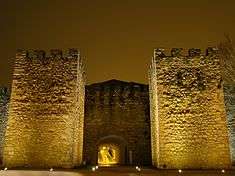
- Fort of Ponta da Bandeira (Portuguese: Forte da Ponta da Bandeira) - also known as the Forte do Pau da Bandeira, the Forte de Nossa Senhora da Penha de França or the Forte do Registo, the fort, which guarded the entrance to the harbour, was originally dedicated to the Santa Virgem Senhora da Penha de França (to which it was referred).[24] This squat rectangular fort guards the entrance to the harbour, accessed by a smalldrawbridge, to terraced spaces (that overlook the town, beach and harbour) and the small chapel (decorated with 17th-century azulejos tile). Until the late 20th century, the fort was used as a service depot for military forces and housed services linked to maritime activities (such as supplies for lifeboats and nautical sports). It was restored between 1958 and 1960, and officially acquired by the municipality of Lagos in 1983, where it was converted into exhibition displays of maritime history, with astrolabes and models of caravels.
- Fort of Pinhão (Portuguese: Forte do Pinhão)
- Military Barracks of Lagos (Portuguese: Edifício Militar em Lagos/Trem de Artilharia)
- Musketeers' Workshop/Warehouse and Saddlery (Portuguese: Edifício Oficina do Espingardeiro/Armazém do Espingardeiro/Selaria)
- Regimental Warehouse/Church of São Brás (Portuguese: Armazém Regimental e Desparecido Igreja de São Brás)
- Tower of Atalaia (Portuguese: Torre da Atalaia)
- Walled/Tower Fortifications of Lagos (Portuguese: Muralhas e Torreões de Lagos)
Religious
- Chapel/Hermitage of São João Baptista (Portuguese: Capela/Ermida de São João Baptista)
- Church of Nossa Senhora do Carmo (Portuguese: Igreja da Nossa Senhora do Carmo)
- Church of Nossa Senhora da Luz (Portuguese: Igreja da Nossa Senhora da Luz)
- Church of Odiáxere (Portuguese: Igreja de Odiáxere)
- Church of Santa Maria (Portuguese: Igreja de Santa Maria/da Misericórdia)
- Church of Santo António (Portuguese: Igreja de Santo António) - its simple façade with the asymmetrical bell towers, date from 1715, and contrast sharply with the extravagantly decorated interior, which is covered in gilded wood carvings and blue-and-white 18th-century azulejo tiles (talha dourada) which fill the walls of the nave, while six Baroque paintings by José Joaquim Rasquinho, representing the miracles of Saint Anthony are hung on its walls. The wooden vault was painted with a trompe-l'oeil effect, while polychrome statues of cherubs playing with animals and fishes are scattered within the interior. It was one of the few buildings to survive the Great Earthquake of 1755, reconstructed by the local commander of Regimental Infantry, who may have added the polychromatic statue of St. Anthony with military sash. Purportedly, King Sebastian attended his last mass in this church, before his ill-fated expedition to Morocco.* Convent of Nossa Senhora do Loreto (Portuguese: Convento de Nossa Senhora do Loreto)
- Church of São Sebastião (Portuguese: Igreja de São Sebastião/de Nossa Senhora da Conceição)
- Hermitage of São Pedro de Pulgão/Nossa Senhora dos Aflitos (Portuguese: Ermida de São Pedro do Pulgão/Nossa Senhora dos Aflitos)
- Ruins of the Hermitage of Santo Amaro (Portuguese: Ruinas da Ermida de São Amaro)
- Ruins of the Convent of the Trinity (Portuguese: Ruinas do Antigo Convento da Trinidade/dos Frades Trinos)
Culture
Many local traditions are celebrated in the municipality and range from gastronomy to traditional handicrafts.
In gastronomy, there are the local specialties: Dom rodrigos and morgados cookies based on local products, such as almonds, figs and eggs. Lagos is also a wine producing region and is famous for its moscatel wine, and also for a strong alcoholic spirit, the aguardente de medronho, made of berries of strawberry tree.
Notable citizens
- São Gonçalo de Lagos (c. 1370 - Torres Vedras; 15 October 1422), saint of the Order of Saint Augustine
- Soeiro da Costa (c. 1390 — c. 1472), navigator and one of the Heroic Twelve of the Lusiadas
- Gil Eanes (born 15th century - died 15th century), navigator and explorer of the 15th century
- Lançarote de Freitas (born 15th century - died 15th century), navigator and merchant during the 15th century
- Diogo Rodrigues (c.1501; Lagos, Portugal - †21 April 1577; Colvá, Goa), navigator, Captain, Governor.
- Júlia Barroso (11 August 1930 - Lisboa; 23 December 1996) actress, singer and teacher
- Júlio Dantas (19 May 1876 — Lisboa; 25 May 1962), doctor, poet, journalist, screenwriter, politician and diplomat
- José Reis, first Portuguese geriatric physician, who founded the Portuguese Geriatric and Gerontological Society in 1951[25]
See also
References
- Notes
- ↑ Detail Regional Map, Algarve-Southern Portugal, ISBN 3-8297-6235-6
- ↑ Instituto Nacional de Estatística
- ↑ Direção-Geral do Território
- ↑ http://www.ine.pt/scripts/flex_v10/Main.html
- ↑ A Long and Uncertain Journey: The 27,000 Mile Voyage of Vasco Da Gama - Joan E. Goodman, Tom McNeely. Retrieved 2013-03-26.
- ↑ "15 destinations on the rise". Tripadvisor.com. Retrieved 2013-03-26.
- ↑ CUP (1970), p.95
- ↑ CUP (1970), p.190
- 1 2 H. Morse Stephens (1891), p.149
- ↑ David Birmingham (2003), p. 27
- ↑ David Birmingham (2003), p. 29
- 1 2 Robert Kerr (1844), p.189
- ↑ David Birmingham (2003), p. 30
- ↑ H. Morse Stephens (1891), p.253
- ↑ CUP (1970), p.275
- 1 2 3 4 5 M. Cachão, P. Terrinha, A. Santos (2005), p.179-180
- 1 2 3 4 Markus H. Forst, Thomas C. Brachert and Joiio Pais (2000), p.290
- 1 2 3 J. Pais et al. (2000), p.279
- ↑ M.T. Antunes et al. (1981), p.9-38
- ↑ M. Estevens (2000), p.271-280
- ↑ Sustainable Tourism Destination EUCC
- ↑ Diário da República. "Law nr. 11-A/2013, page 552 59" (pdf) (in Portuguese). Retrieved 24 July 2014.
- ↑ Guide to the cultural heritage of the Algarve, By Turismo of Portugal:Algarve, OCLC 860570547
- ↑ Ponta da Bandeira (or Pau da Bandeira) are actually more recent names given the fortress, named for the area of Lagos on which it is actually located.
- ↑ "Breve historial da sociedade Portuguesa de geriatria e gerontologia". Sociedade Portuguesa de Geriatria e Gerontologia. Retrieved 7 February 2013.
- Sources
- Taste the Difference (PDF), Faro, Portugal: Associação Turismo do Algarve, 2005, retrieved 24 August 2011
- Paula, Rui Mendes (1992), Lagos: Evolução Urbana e Património (in Portuguese), Lagos, Portugal: Câmara Municipal de Lagos, p. 392, ISBN 978-972-95676-2-9
- Cardo, Mário (1998), Lagos Cidade: Subsídios para uma Monografia (in Portuguese), Lagos, Portugal: Grupo dos Amigos de Lagos, p. 80
- Coutingo, Valdemar (2008), Lagos e o Mar Através dos Tempos (in Portuguese), Lagos, Portugal: Câmara Municipal de Lagos, p. 95
- Pel-Elaboração do Plano Estratégico do Município de Lagos: Caracterização da Oferta Turística (PDF) (in Portuguese), Câmara Municipal de Lagos, 2005, retrieved 24 August 2011
- Kerr, Robert (1844), A general history and collection of voyages and travels, arranged..., 2, Edinburgh, Scotland: William Blackwood
- Stephens, H. Morse (1891), The Story of the Nations: Portugal, London, England: G.P. Puntam's Sons
- CUP, ed. (1970). History of Portugal: Pamphlet Collection. CUP Archive. ISBN 1-00-128780-0.
- Forst, Markus H.; Brachert, Thomas C.; Pais, João (2000), "High-resolution correlation of coastal cliff sections in the Lagos-Portimao Formation (Lower-Middle Miocene, central Algarve, Portugal)", Ciênçias da Terra (14), Lisbon, Portugal: Universidade Nova de Lisboa, pp. 289–296
- Cachão, M.; Terrinha, P.; Santos, A. (September 2005), "Meso-Cenozoic of the Algarve", Episodes, 28 (3), Coimbra, Portugal: Universidade de Coimbra, pp. 179–180
- Pais, J.; Legoinha, P.; Elderfield, H.; Sousa, L.; Estevens, M. (2000), "The Neogene of Algarve (Portugal)", Ciênçias da Terra (14), Lisbon, Portugal: Universidade Nova de Lisboa, pp. 277–288
- Estevens, M. (2000), "Neogene marine mammals inPortugal. Paleogeographical and palcoccological significance.", 1º Congresso sobre c Cenozoíco de Portugal, Monte de Caparica, Portugal, pp. 271–280
- Antunes, M.T.; Jonet, S.; Nascimento, A. (1981), "Vertebres (crocodiliens, poissons) du Miocene marin de I' Algarve occidentale", Ciênças da Terra (UNL) (in French) (6), Lisbon, Portugal, pp. 9–38
External links
| Wikimedia Commons has media related to Lagos, Portugal. |
| Wikisource has the text of the 1911 Encyclopædia Britannica article Lagos (Portugal). |
-
 Lagos (Portugal) travel guide from Wikivoyage
 - I Support Lagos: The community web portal of information and news of Lagos, Portugal
| Municipality of Faro District (Algarve) |
|
|---|
 |
 |
 |
 |
 |
 |
 |
 |
 |
 |
 |
 |
 |
 |
 |
 |
| Albufeira | Alcoutim | Aljezur | Castro Marim | Faro | Lagoa | Lagos | Loulé | Monchique | Olhão | Portimão | São Brás de Alportel | Silves | Tavira | Vila do Bispo | Vila Real de Santo António |