Farranfore to Valencia Harbour Railway
.jpg)
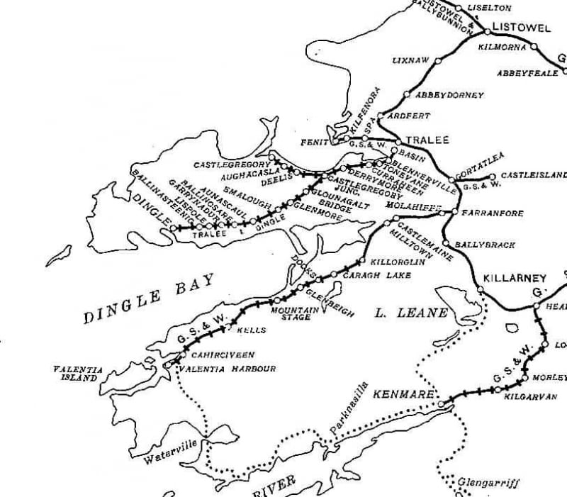
The Farranfore to Valencia Harbour Railway was 39.5 miles (63.5 km) long single-track broad gauge railway line that operated from 1892 to 1960 along Dingle Bay's southern shore in Ireland. It was the most westernly railway in Europe.[1]
History
The Great Southern and Western Railway Company (GS & WR) opened the 12.5 miles (20.1 km) long rail link between Farranfore and Iveragh Road in Killorglin with the Irish gauge of 5 ft 3 in (1,600 mm) on 15 January 1885. The line was extended by 27 miles (43.4 km) to Valentia Harbour commencing in 1890 and formally opened on 12 September 1893.[2][3] The branch line left the Tralee-Mallow main line at Farranfore and headed west through some of Ireland's most spectacular scenery as it climbed through County Kerry's mountainous countryside, along Dingle Bay's southern shore.[1] It served as the main transport system for the Iveragh Peninsula for 75 years. The last train departed Killorglin on 30 January 1960, and the line was closed on 1 February 1960.[3][4]
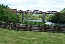
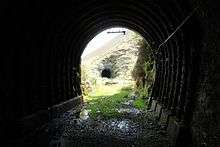
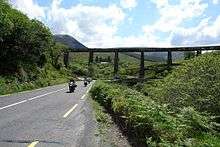
The Laune Viaduct in Killorglin, two tunnels and the Gleensk Viaduct are still standing.[5][6] Most of its other buildings have been demolished and their sites were used for other purposes.[2][3] It was announced in June 2013 that the section of the disused and disassembled railway linking Cahirciveen to Reenard would be signed over by Irish Rail’s parent company, CIÉ to Kerry County Council for building the 3.57 miles (5.75 km) long Fertha greenway, a combined walking and cycling path which features on Lonely Planet’s best things to do in time.[7]
Railway stations
- Farranfore railway station[8]
- Molahiffe railway station
- Castlemaine (GSWR) railway station
- Milltown Halt railway station
- Killorglin railway station
- Caragh Lake railway station
- Dooks railway station
- Glenbeigh railway station
- Mountain Stage railway station
- Kells (GSWR) railway station
- Cahirciveen railway station
- Valentia Harbour railway station
Literature
- Patrick O'Sullivan: The Farranfore to Valencia Harbour Railway, Volume 1. The Oakwood Press, United Kingdom, 2003, ISBN 0853616043.
- Patrick O'Sullivan: The Farranfore to Valencia Harbour Railway, Volume 2. The Oakwood Press, United Kingdom, 2003, ISBN 0853616108.
External links
References
| Wikimedia Commons has media related to Killorglin to Valentia Railway. |
- 1 2 Joan O'Sullivan: The railway line from Farranfore to Valentia harbour in Co Kerry. Youtube Video.
- 1 2 Memorial stone in Killorglin.
- 1 2 3 Killorglin Archive Society: Killorglin to Valentia Railway 1892-1960. Amazing Images. Youtube Video.
- ↑ Killorglin Archive Society: Killorglin To Valentia Railway Part 2. Youtube Video.
- ↑ Ordnance Survey Ireland: The Gleensk Viaduct on an old map.
- ↑ Industrial archeaology in rural Ireland: Gleensk Viaduct, Co Kerry (1893).
- ↑ Cian Ginty: Disused Kerry railway to be signed over to council for greenway. Published on www.irishcycle.com on 23 June 2014.
- ↑ Map Rail Ireland Viceregal Commission 1906.
Coordinates: 52°01′53″N 10°04′07″W / 52.03128°N 10.06850°W