Fir of Hotova National Park
| Fir of Hotova National Park | |
|---|---|
 | |
| Location | Southern Albania |
| Nearest city | Përmet |
| Area | 34,361 ha |
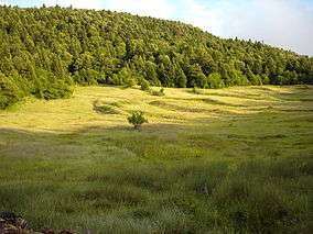
Fir of Hotova (Albanian: Bredhat e Hotovës) (also known as Bredhat e Hotovës-Dangëlli) is a national park in southern Albania, in the region of Frashër, 35 km north-east of Përmet. The park has an area of 34,361 hectares and is known as the natural lungs of Southern Albania. It takes its name from the Hotova Fir which is considered one of the most important Mediterranean plant relics of the country.
With a coverage area of 34,361 hectares consisting mainly of Bulgarian Fir, the area was declared a national park by the Albanian Government on January 15, 1996 and is under the jurisdiction of the Permet District Forest Service, and National Agency of Protected Areas of Albania (AKZM). The area is by far the most protected forest massif in Albania, successfully resisting any damage or deforestation by man.
Geography
The impressive view of the park can be seen from Lumica Valley entrance up to Kokojka Mt summit. At the height of 800-1000 meters, there are vast meadows surrounded by centuries-old large trees forming a giant greenbelt. In the winter, visitors can appreciate the snow blanket covering the firs, and in the summer the abundance of fresh air away as an escape from the Albanian summer heat. Note that as of 2015, the road leading to the park from SH75 in Piskova is unpaved and requires a 4x4. There are no food facilities in the park, though food can be brought or ordered at nearby villages. Water can be secured from fresh water fountains located on the roadside along the way.
Flora and fauna

Fir of Hotova contains the largest area of Bulgarian Fir in the Balkans. Other species include maple, black hornbeam, ilex, red and black juniper, raspberry etc. Some of the park’s fauna includes the brown bear, wolf, fox, wild boar, hare, squirrel, wild goat, etc. Deer can also be seen on the pastures deep inside the forest.
Landmarks
- Frasheri Brothers Tower House and Museum in Frasher reconstructed in the 1970s by the Albanian government. The museum features documents, photographs, and sculptures on Frasheri Brothers origins and their contribution to the Albanian Renaissance.
- Langarica Canyon perfect for rafting
- Katiu Ottoman Bridge and Benja Thermal Waters
- Variety of trails around the area are marked and can be found HERE
References
External links
| Wikivoyage has a travel guide for Fir of Hotova National Park. |
| Wikimedia Commons has media related to Category:Bredhi i Hotovës-Dangelli. |
| National | |
|---|---|
| Archaeological | |
| See also | |
Coordinates: 40°18′13″N 20°24′40″E / 40.30361°N 20.41111°E