Mount Dajt
| Mount Dajt | |
|---|---|
 Mount Dajt seen from the Dajti Ekspres Cable Car, July 2007 | |
| Highest point | |
| Elevation | 1,613 m (5,292 ft) |
| Coordinates | 41°21′57″N 19°55′32″E / 41.36583°N 19.92556°ECoordinates: 41°21′57″N 19°55′32″E / 41.36583°N 19.92556°E |
| Geography | |
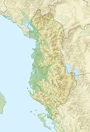 Mount Dajt Albanian mountains | |
| Location | Albania |
| Parent range | Kruja chain |
Mount Dajt (Albanian: Mali i Dajtit) is a mountain and national park in central Albania, to the east of Tirana. Its highest peak is at 1,613 m (5,292 ft). In winter, the mountain is often covered with snow, and it is a popular retreat to the local population of Tirana that rarely sees snow falls. Its slopes have forests of pines, oak and beech, while its interior contains canyons, waterfalls, caves, a lake, and an ancient castle.
Dajti Mountain was declared a National Park in 1966, and has an expanded area of about 29,384 ha since 2006.[1] It lies under the jurisdiction and administration of the Agency of Parks and Recreation at Tirana Municipality, having previously been under the Tirana Forest Service Department.
Mount Dajti National Park
| Mount Dajti National Park | |
|---|---|
|
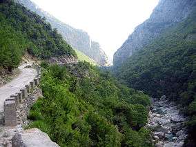
River on Dajti | |
| Location | Central Albania |
| Nearest city | Tirana |
| Area | 29,384 ha |

Mount Dajti National Park (also Dajti Mountain National Park) (Albanian:Parku Kombëtar i Malit të Dajtit or Parku Kombëtar i Dajtit) is situated 26 km east of the capital and 50 km east of Tirana International Airport Mother Teresa. The park has a surface area of 29,384 hectares, is highly frequented by day and considered the 'Natural Balcony of Tirana'.
Dajti Mountain together with Priska Mountain (1353m) to the south and Brari Mountain to the North consists of the national park. The 3,300 hectares (33 km2) protection area was expanded on 21 June 2006 by many more times with the core zone now being 9,000 hectares (90 km2). In addition to the forests and beautiful mountain landscapes with many wild flowers, numerous mammals are protected as well. In the park there exist wild boar, eurasian wolf, red fox, European hare, brown bears and wildcats. In the lower part of the mountains the vegetation is scrub determined with much heath, myrtle and fragaria. Oak dominates at around the 1,000 metres altitude zone following with beech forests with some conifers. Perched on the top there is almost no vegetation.
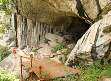
Brari Mountain to the north is also part of the protected area. It is located near Brar village containing panoramic Brari Canyon, Brari Ottoman Bridge, and a cave. One of Tirana's main water sources, Bovilla Lake is located to the northeast of Brar village. On the other extremity of the park along Erzeni River is found the impressive Pellumbas Cave, Erzeni Canyon, and Peshkashesh Dam. Another natural attraction is the spectacular Shengjini Waterfall (Ujvara e Shengjinit) located near Shengjergj village. There also exists a protected area to the east of the park called the Mali me Gropa-Biza-Martaneshi Protected Landscape featuring mountain meadows, forests, and several mineral water sources. Prior to the 90s, this area served as one of the places where opponents of the communist regime were rounded up during communism in Albania.
Dajti Mountain can be reached through a narrow asphalted mountain road onto an area known as Fusha e Dajtit. This was the location of a summer camp but now is the site of many restaurants and radio/TV transmitters. From this small area there is an excellent view of Tirana and its plain. This is the reason this place has been named as the Balcony of Tirana. From June 2005, hikers and visitors of the mountain can use an Austrian built gondola lift from the eastern outskirts of Tirana to Fusha e Dajtit (Plain of Dajti) at 1050 meters altitude.[2] On the summit of Mount Dajti there exist several transmitters of radio and television.
Lately, traces of prehistoric settlements and fortifications from later periods have been discovered in the area.
Environmental problems
A serious environmental problem on mountain Dajt is how to deal with garbage. This is partially caused by restaurants and hotels that leave rubbish everywhere since there are few garbage bins in the region. Another major problem on the mountain is deforestation. For this responsible are the Ministry of the Environment, the Municipality of the region, the foresters (rangers) and the people who live in the area. Water pollution of the lake and air pollution caused by cars crossing the mountain roads are also problematic.
See also
- List of mountains in Albania
- Dajti Castle
- Tourism in Albania
References
- ↑ http://www.mjedisi.gov.al/files/userfiles/Biodiversiteti/VKM/2006-VKM_nr_402,_dt_21-6-2006_Shpalljen_PK_Mali_i_Dajtit.pdf
- ↑ "10 Great Ways To Spend A Weekend in Tirana". Travel Addicts. Retrieved 6 November 2016.
External links
| Wikimedia Commons has media related to Dajt. |
- Dajti Ekpres Cable Car
- Dajti Recreation Park at the Agency of Parks and Recreation of Tirana Municipality (Albanian)
- All Dajti Mt Trails
- Some Dajti Hiking Trails
- Hiking to top of Dajti Mt by Outdoor Albania
| National | |
|---|---|
| Archaeological | |
| See also | |