Firth of Tay
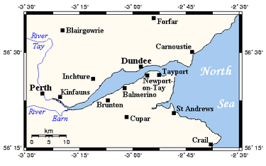
The Firth of Tay /ˈteɪ/ (Scottish Gaelic: Linne Tatha) is a firth in Scotland between the council areas of Fife, Perth and Kinross, the City of Dundee and Angus, into which Scotland's largest river in terms of flow, the River Tay empties. The firth has a maximum width of 3 mi (4.8 km) at Invergowrie.[1]
Two bridges span the firth, the Tay Road Bridge and the Tay Rail Bridge.[2]
The firth has one major island, the marshy Mugdrum Island.[3]
The Firth of Tay in Antarctica was discovered in 1892-93 by Captain Thomas Robertson of the Dundee whaling expedition and named by him after the one in Scotland. He also named nearby Dundee Island in honour of the main city on the firth.
Natural heritage
The Firth of Tay and Eden Estuary were designated a Ramsar sites on 28 July 2000, as a Special Protection Area on 2 February 2000 and as a Special Area of Conservation on 17 March 2005. Several parts are within a site of special scientific interest - Inner Tay Estuary, Monifieth Bay, Tayport-Tentsmuir Coast. The Invergowrie Bay section is a local nature reserve.
The Firth of Tay is outstanding for its extensive sand and mudflats, its population of common seals and for its wintering birds such as oystercatcher, bar-tailed godwit, shelduck and velvet scoter. There is good access to much of the shoreline and many good wildlife watching opportunities.
At some 15 km in length, the reedbed on the north shore of the inner estuary is thought to be the most extensive in Britain.
Towns and villages along the coast
- Balmerino
- Broughty Ferry
- Dundee
- Invergowrie
- Kingoodie
- Monifieth
- Newburgh
- Newport-on-Tay
- Tayport
- Woodhaven
- Wormit
Places of interest
- Balmerino Abbey
- Broughty Castle Museum
- Mugdrum Island
- Tay Rail Bridge
- Tay Road Bridge
- Tentsmuir Forest
References
- ↑ "Tay, Firth of". Angus Council. Retrieved 26 February 2012.
- ↑ "The Tay Bridges". Tay Estuary. Retrieved 26 February 2012.
- ↑ "Historical perspective for Mugdrum Island". Gazetteer for Scotland. Retrieved 26 February 2012.
Coordinates: 56°26′N 3°00′W / 56.433°N 3.000°W