River Tay
| River Tay | |
| Tatha | |
| River | |
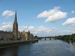
 Looking upstream (north) along the Tay from the centre of Perth | |
| Country | United Kingdom |
|---|---|
| Constituent country | Scotland |
| Tributaries | |
| - left | River Lyon, River Tummel, River Isla |
| - right | River Almond, River Earn, River Braan |
| Source | Allt Coire Laoigh |
| - location | Ben Lui, Scottish Highlands, UK |
| - elevation | 720 m (2,362 ft) |
| - coordinates | GB 56°23′07″N 4°47′36″W / 56.38528°N 4.79333°W |
| Mouth | Firth of Tay, North Sea |
| - location | Between Perth, Scotland and Dundee, Scotland, UK |
| - elevation | 0 m (0 ft) |
| - coordinates | GB 56°21′18″N 3°17′54″W / 56.35500°N 3.29833°WCoordinates: GB 56°21′18″N 3°17′54″W / 56.35500°N 3.29833°W |
| Length | 188 km (117 mi) |
| Basin | 4,970 km2 (1,919 sq mi) |
| Discharge | for Ballathie |
| - average | 169 m3/s (5,968 cu ft/s) |
| - max | 1,965 m3/s (69,393 cu ft/s) |
| - min | 11 m3/s (388 cu ft/s) |

The River Tay (Scottish Gaelic: Tatha) is the longest river in Scotland and the seventh-longest in the United Kingdom. The Tay originates in western Scotland on the slopes of Ben Lui (Scottish Gaelic: Beinn Laoigh), then flows easterly across the Highlands, through Loch Dochart, Loch Iubhair and Loch Tay, then continues east through Strathtay (see Strath), in the centre of Scotland, then southeasterly through Perth, where it becomes tidal, to its mouth at the Firth of Tay, south of Dundee. It is the largest river in the UK by measured discharge.[1] Its catchment is approximately 2,000 square miles (5,200 km2), the Tweed's is 1,500 square miles (3,900 km2) and the Spey's is 1,097 square miles (2,840 km2).
History
In the 19th century the Tay Rail Bridge was built across the firth at Dundee as part of the East Coast Main Line, which linked Aberdeen in the north with Edinburgh and London to the south. The bridge, designed by Sir Thomas Bouch, officially opened in May 1878. On 28 December 1879 the bridge collapsed as a train passed over. The entire train fell into the firth, with the loss of 75 passengers and train crew. The event was commemorated in a poem, The Tay Bridge Disaster, written by William McGonagall, a notoriously unskilled Scottish poet. The critical response to his article was enhanced as he had previously written two poems celebrating the strength and certain immortality of the Tay Bridge. A. J. Cronin's first novel, Hatter's Castle (1931), includes a scene involving the Tay Bridge Disaster, and the 1942 filmed version of the book recreates the bridge's catastrophic collapse.
The rail bridge was rebuilt, and in the 1960s the Tay Road Bridge was built.
During the winters of 2009–10 and 2010–11, the Tay froze over as far as the Tay Road Bridge, and ice floes remained for weeks despite a thaw.
Several places along the Tay take their names from it, or are believed to have done so:
- Broughty - Bruach Tatha, Bank of the Tay
- Taymouth - Near the mouth of Loch Tay.
- Tayside - A former Scottish Government region
Course


The Tay drains much of the lower region of the Highlands. It originates on the slopes of Ben Lui (Beinn Laoigh), only around 25 miles (40 km) from the west coast town of Oban, in Argyll and Bute.[1] In 2011, the Tay Western Catchments Partnership determined as its source (as based on its 'most dominant and longest' tributary) a small lochan on Allt Coire Laoigh south of the summit.[2] The river has a variety of names in its upper catchment: for the first few miles it is known as the River Connonish; then the River Fillan; the name then changes to the River Dochart until it flows into Loch Tay at Killin.
The River Tay emerges from Loch Tay at Kenmore, and flows from there to Perth which, in historical times, was its lowest bridging point. Below Perth the river becomes tidal and enters the Firth of Tay. The largest city on the river, Dundee, lies on the north bank of the Firth. On reaching the North Sea, the River Tay has flowed 120 miles (190 km) from west to east across central Scotland.
The Tay is unusual amongst Scottish rivers in having several major tributaries, notably the Earn, the Isla, the River Tummel, the Almond and the Lyon.[1]
A flow of 2,269 m3/s (80,100 cu ft/s) was recorded on 17 January 1993, when the river rose 6.48 m (21 ft 3 in) above its usual level at Perth, and caused extensive flooding in the city. Were it not for the hydro-electric schemes upstream which impounded runoff, the peak would have been considerably higher. The highest flood recorded at Perth occurred in 1814, when the river rose 7 m (23 ft) above its usual level, partly caused by a blockage of ice under Smeaton's Bridge. Other severe flood events occurred in 1210 and 1648 when bridges over the Tay at Perth were destroyed.
Ecology

The river is of high biodiversity value and is a Site of Special Scientific Interest (SSSI) maintaining a flagship population of Atlantic salmon (Salmo salar), Freshwater pearl mussel (Margaritifea margaritifera) and native species such as the Eurasian otter (Lutra lutra).[1] Freshwater pearl mussels are one of Scotland's most endangered species and the River Tay hosts two-thirds of the world's remaining stock.[3]
The Tay is internationally renowned for its Atlantic salmon fishing and is one of the best salmon rivers in the United Kingdom, and western Europe, attracting anglers from all over the world. The lowest ten miles of the Tay, including prestigious beats like Taymount or Islamouth, provides most of the cream of the Tay. The largest rod caught salmon in Britain, caught on the Tay by Miss Georgina Ballantine in 1922, weighing 64 pounds (29 kg), retains the British record. The river system has salmon fisheries on many of its tributaries including the Earn, Isla, Ericht, Tummel, Garry, Dochart, Lyon and Eden.[4] Dwindling catches include a 50% reduction in 2009 so the Tay District Salmon Fisheries Board ordered a catch-and-release policy for females all season, and for males until May, beginning in the January 2010 fishing season. Research by the North Atlantic Salmon Conservation Organisation has shown that the number of salmon dying at sea has doubled or trebled over the past 20 years, possibly due to overfishing in the oceans where salmon spend two years before returning to freshwater to spawn. The widespread collapse in Atlantic salmon stocks suggests that this is not solely a local problem in the River Tay.[5]
The first Eurasian beaver (Castor fiber) living wild in Scotland in over 400 years was captured in the River Tay in 2007 because it may have been illegally released or not of the proper genetic stock. There is an earlier undocumented sighting of a beaver in the River Earn, a Tay tributary, in May 2001. The Tay watershed beaver may be escapees from Tayside captive beaver enclosures.[6] The beaver became extinct in Great Britain towards the end of the 18th century, the last reference to beavers in England dating to 1789.[7] It is estimated that at least 20, and possibly up to 100, beavers live on the Tay River, although these were targeted for trapping by the Scottish Natural Heritage,[8] a decision was made to allow them to stay.[9]
Proponents of the Tayside beavers argue that they have not been proven to be of "wrong" genetic stock and there is scientific evidence to support that they may represent a rather ideal mix of western European populations, since any single relict population in western Europe is relatively genetically depauperate.[10] Scottish Natural Heritage did import beaver from Norway and legally released them in Knapdale in 2009.[11][12][13] In early December 2010, the first of the wild Tayside beavers was trapped by Scottish Natural Heritage on the River Ericht in Blairgowrie, Perthshire and was held in captivity in Edinburgh Zoo. It died within a few months and Scottish Natural Heritage ended its trapping program.[14]
Tay ferries
A passenger and vehicle ferry service operated across the River Tay between Craig Pier, Dundee and Newport-on-Tay in Fife. In Dundee, the ferries were known as "the Fifies".[15] The service was discontinued on the opening of the Tay Road Bridge on 18 August 1966.
The last vessels to operate the service were PS B. L. Nairn and two more modern ferries equipped with Voith Schneider Propellers, MVs Abercraig and Scotscraig.
Cultural references

The Tay is mentioned in William McGonagall's poems The Tay Bridge Disaster and Railway Bridge of the Silvery Tay and the German poet Theodor Fontane has mentioned the Tay in his poem Die Brück' am Tay. It is mentioned in the Steeleye Span song "The Royal Forester". Many Rolls-Royce civil aero-engines are named after British rivers, one of which is the Rolls-Royce Tay.
See also
- List of navigation authorities in the United Kingdom
- List of rivers of Scotland
- List of waterway societies in the United Kingdom
- Rivers and Fisheries Trusts of Scotland (RAFTS)
References
- 1 2 3 4 River Tay, United Kingdom (PDF) (Report). Peer-Euraqua network of hydrological observatories. Retrieved 2010-12-29.
- ↑ "BBC News - Source of River Tay 'pinpointed'". BBC News.
- ↑ River Tay Special Area of Conservation (PDF) (Report). Scottish Natural Heritage. Retrieved 2011-04-16.
- ↑ "Fish Tay". FishPal. 2011-01-11. Retrieved 2011-01-15.
- ↑ Frank Urquhart (2010-01-11). "In Scotland, Anglers Told to Put River Tay Salmon Back". Atlantic Salmon Federation. Retrieved 2011-01-15.
- ↑ "Wild beaver back in Scotland". Retrieved 2007-12-11.
- ↑ Coles, Bryony (2007). Beavers in Britain's Past. Oxford: Oxbow Books. p. 187. ISBN 978-1-84217-226-1. Retrieved 2011-01-04.
- ↑ Iain Howie (2010-12-03). "Perthshire beavers to be rounded up". Perthshire Advertiser. Retrieved 2010-12-29.
- ↑ Severin Carrell (2010-12-03). "U-turn over plans to trap river Tay beavers". The Guardian. Retrieved 2015-04-21.
- ↑ Duncan J. Halley (January 2011). "Sourcing Eurasian beaver Castor fiber stock for reintroductions in Great Britain and Western Europe". Mammal Review. 41: 40–53. doi:10.1111/j.1365-2907.2010.00167.x.
- ↑ "Beavers arrive for spring release". BBC News. 2008-11-21. Retrieved 2010-12-29.
- ↑ "Forest restoration project begins". BBC News. 2009-11-03. Retrieved 2010-12-29.
- ↑ "Viva la beaver: Britain's population is beginning to thrive again". The Independent. 2008-07-10. Retrieved 2010-12-29.
- ↑ "Sole trapped beaver Erica died in captivity". Courier News. 2011-04-06. Retrieved 2011-04-16.
- ↑ "The Making of Modern Dundee" (PDF).
Gallery
_meets_the_River_Tay_-_geograph.org.uk_-_113846.jpg) Confluence of the Rivers Isla and Tay
Confluence of the Rivers Isla and Tay Stanley Mills
 Canoeists on the Tay at Stanley
 The Tay passing under Smeaton's Bridge in Perth
 Friarton Bridge, where the M90 motorway crosses the Tay
 River Tay from Kinnoull Hill in Winter
 Confluence of Rivers Earn (left) and Tay
 The Tay from Newburgh, Fife, showing Mugdrum Island
 River Tay near Longforgan
 Invergowrie bay
 The Tay Rail Bridge
 The Tay road bridge looking towards Fife
 Oil rig maintenance at Stannergate, Dundee
 Broughty Ferry from Stannergate, Dundee
 Broughty Castle, Broughty Ferry
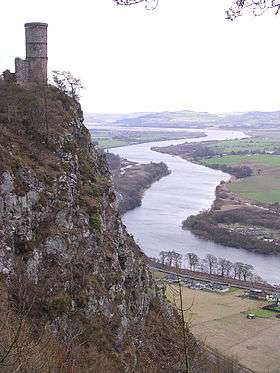
 The Tay meandering its way east. Viewed from Kinnoull Hill in Perth.
External links
- The Development of the Historic Burgh of Perth
- From the Ganga to the Tay by Bashabi Fraser, 2009. Luath Press Ltd. ISBN 1906307954.