Fiskåbygd
| Fiskåbygd Fiskå | |
|---|---|
| Village | |
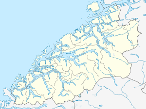
 Fiskåbygd Location in Møre og Romsdal | |
| Coordinates: 62°06′02″N 05°33′28″E / 62.10056°N 5.55778°ECoordinates: 62°06′02″N 05°33′28″E / 62.10056°N 5.55778°E | |
| Country | Norway |
| Region | Western Norway |
| County | Møre og Romsdal |
| District | Sunnmøre |
| Municipality | Vanylven Municipality |
| Area[1] | |
| • Total | 0.55 km2 (0.21 sq mi) |
| Elevation[2] | 20 m (70 ft) |
| Population (2013)[1] | |
| • Total | 348 |
| • Density | 633/km2 (1,640/sq mi) |
| Time zone | CET (UTC+01:00) |
| • Summer (DST) | CEST (UTC+02:00) |
| Post Code | 6143 Fiskå |
Fiskåbygd or Fiskå is a coastal village that is also the administrative centre of Vanylven Municipality in Møre og Romsdal county, Norway. The village is located about 100 kilometres (62 mi) southwest of the city of Ålesund, about 12 kilometres (7.5 mi) east of the village of Myklebost, and about 30 kilometres (19 mi) southwest of the village of Rovdane. Fiskåbygd lies along the shores of the Vanylvsfjorden, east of the Stadlandet peninsula in Selje Municipality.
The 0.55-square-kilometre (140-acre) village has a population (2013) of 348, giving the village a population density of 633 inhabitants per square kilometre (1,640/sq mi).[1]
The nearest church is Vanylven Church, located in Slagnes about 15 kilometres (9.3 mi) to the southwest.
References
- 1 2 3 Statistisk sentralbyrå (1 January 2013). "Urban settlements. Population and area, by municipality.".
- ↑ "Fiskåbygd" (in Norwegian). yr.no. Retrieved 2010-09-13.