Fleam Dyke
Coordinates: 52°09′58″N 0°14′31″E / 52.166°N 0.242°E
Fleam Dyke is an earthwork in eastern Cambridgeshire, England, it was generally assumed to be Anglo-Saxon of origin. As a few potsherds of the early and late Bronze age were found in the most eastern part of the dyke it seems that much older earthworks have been used. The archaeologist Prof. McKenny Hughes therefore preferred to speak of 'multi-period dykes' while more recently Alison Taylor cautiously concluded that though most defensive dykes in Cambridgeshire have been shown to be Anglo-Saxon in their final phase, they often seem to be preceded by Iron Age works, and elsewhere in East Anglia they are commonly Iron Age in date.[1]
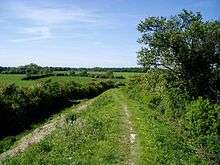
The main surviving section of the dyke consists of a massive bank and ditch running 4 miles between Fulbourn and Balsham. There is also a section near Fen Ditton, or High Ditch, which acquired its name (Dittone, meaning "the village by the ditch") from its proximity to the Dyke.
History
In the late 6th or early 7th century competition between neighbouring Saxon tribes was particularly fierce. It is believed that the dyke would have been used to demarcate the boundary of a tribe's influence as well as a barrier to the British kingdoms to the west.
At its creation, the chalk barrier ran from The Fens in the north-west to the clay woodlands in the south making circumvention difficult.[2] Findings such as the small quantity of silt in the ditch fills also suggest that the dyke fell into disuse soon after it was built.
The dyke is one of several earthworks in south Cambridgeshire designed to control movement along the ancient Roman roads. The others include Devil's Dyke, Brent Ditch and Bran ditch.
Black Ditches, Cavenham is a fifth earthwork guarding the ancient Icknield Way and can be found in Suffolk just north west of Bury St Edmunds
Heritage

The course of the dyke is now controlled by English Heritage as a Scheduled Ancient Monument,[3] as well as Site of Special Scientific Interest. A well-kept footpath runs the full length of the dyke.
The path is also home to several rare species of flora including the clustered bellflower and the bastard toadflax. It is also an excellent example of a chalk grassland. It is on a stretch of these open grassland banks south of the A11 that rare examples of the Common Juniper tree can be found
Current Use
Amazon are believed to use the site to test Amazon Prime Air drones, to the discontent of some local groups who feel it is incompatible with its status.[4]
See also
- East Cambridgeshire
- Harcamlow Way
References
- ↑ Taylor, Alison (1998), Archaeology of Cambridgeshire, 2, Cambridgeshire County Council, p. 29
- ↑ Sketch Map of the south-west defence lines of the Wuffing kingdom, wuffings.co.uk, retrieved 2009-04-02
- ↑ Historic England. "Fleam Dyke (1006931)". National Heritage List for England.
- ↑ "Amazon drone trial over Fleam Dyke 'horrifying'".
- Fox.C (1923) The archaeology of the Cambridge region: a topographical study of the Bronze, Early Iron, Roman and Anglo-Saxon Ages, with an introductory note on the Neolithic Age. Cambridge: Cambridge University Press
External links
![]() Media related to Fleam Dyke at Wikimedia Commons
Media related to Fleam Dyke at Wikimedia Commons