Flodday near Vatersay
For other places with the same name, see Flodday.
Not to be confused with Flodday, Sound of Barra.
| Gaelic name | Flodaigh |
|---|---|
| Norse name | floti |
| Meaning of name | 'raft' or 'float' island |
| Location | |
 Flodday Flodday shown within the Outer Hebrides | |
| OS grid reference | NL612924 |
| Physical geography | |
| Island group | Uists and Barra |
| Area | 23 ha (0.09 sq mi)[1] |
| Highest elevation | 43 m (141 ft) |
| Administration | |
| Sovereign state | United Kingdom |
| Country | Scotland |
| Council area | Na h-Eileanan Siar |
| Demographics | |
| Population | 0[2] |
| References | [3][4] |
Flodday (Scots Gaelic: Flodaigh) is an uninhabited island, south west of Barra in the Western Islands of Scotland.
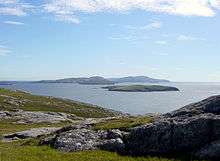
Flodday (nearest island), viewed from Vatersay.
Geography and geology
Flodday is one of the Barra Isles, lying one mile west of Sandray. It consists of three parts, with a natural rock arch between the larger two. Facing west there are black cliffs.[3]
Wildlife
The island has a small grey seal colony and is home to a subspecies of the Dark Green Fritillary butterfly (Argynnis aglaja scotica).[3]
Footnotes
- ↑ Rick Livingstone’s Tables of the Islands of Scotland (pdf) Argyll Yacht Charters. Retrieved 12 Dec 2011.
- ↑ National Records of Scotland (15 August 2013) (pdf) Statistical Bulletin: 2011 Census: First Results on Population and Household Estimates for Scotland - Release 1C (Part Two). "Appendix 2: Population and households on Scotland’s inhabited islands". Retrieved 17 August 2013.
- 1 2 3 Haswell-Smith, Hamish (2004). The Scottish Islands. Edinburgh: Canongate. ISBN 978-1-84195-454-7.
- ↑ Ordnance Survey. Get-a-map (Map). 1:25,000. Leisure. Ordinance Survey. Retrieved 21 August 2013.
Coordinates: 56°53′55″N 7°34′01″W / 56.89865°N 7.56704°W
This article is issued from Wikipedia - version of the 7/8/2016. The text is available under the Creative Commons Attribution/Share Alike but additional terms may apply for the media files.