Florencia, Caquetá
| Florencia | ||
|---|---|---|
| Municipality and city | ||
| ||
| Nickname(s): Golden Gate to the Colombian Amazonia | ||
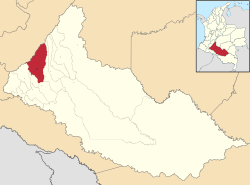 Location of the municipality and town of Florencia in the Caquetá Department of Colombia. | ||
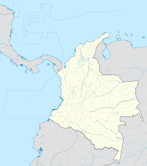 Florencia Location in Colombia | ||
| Coordinates: 1°36′50″N 75°36′46″W / 1.61389°N 75.61278°WCoordinates: 1°36′50″N 75°36′46″W / 1.61389°N 75.61278°W | ||
| Country |
| |
| Region | Amazonas Region | |
| Department | Caquetá Department | |
| Founded | 1902 | |
| Incorporated | 1912 | |
| Founded by | Doroteo de Pupiales | |
| Named for | Florence | |
| Government | ||
| • Mayor | María Susana Portela | |
| Area | ||
| • Municipality and city | 2,292 km2 (885 sq mi) | |
| • Urban | 14.56 km2 (5.62 sq mi) | |
| Elevation | 242 m (794 ft) | |
| Population (2012)[1] | ||
| • Municipality and city | 163,323 | |
| • Rank | 35th in Colombia | |
| • Density | 71/km2 (180/sq mi) | |
| • Urban | 141,804 | |
| • Urban density | 9,700/km2 (25,000/sq mi) | |
| • Rural | 21,519 | |
| DANE | ||
| Demonym(s) |
Florencian florenciano (m), -na (f) florentino (m), -na (f) | |
| Ethnicity[1] | ||
| • White/Mestizo | 95.9% | |
| • Afro | 3.3% | |
| • Amerindian | 0.8% | |
| Time zone | Colombia Standard Time (UTC-05) | |
| Postal code | 180001–180009 | |
| Area code(s) | 57 + 8 | |
| Major airport | Gustavo Artunduaga Paredes Airport | |
| Website | Official website (Spanish) | |
.svg.png)
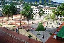
Florencia (Spanish pronunciation: [floˈɾensja], English: Florence) is a municipality and capital city of the Department of Caquetá, Colombia. It is the most important city in southeast Colombia because of its population as well as its more than a hundred years of history. It is the boundary between mountains and the Amazon. It lies on the Orteguaza River which flows into the Caqueta River. Its population is roughly 165,000.
History
Florencia was founded on December 25, 1902 by Capuchin Friar Doroteo De Pupiales (1876-1959) Born in Pupiales, Nariño, Colombia.
Geography
Florencia is located by the steps of the Cordillera Oriental mountain range. The municipality of Florencia limits to the north with the Huila Department and the municipality of El Paujil, to the east with the municipalities of El Paujil and La Montañita, to the south with the municipalities of Milán and Morelia, and to the west with the municipality of Belén de Andaquies and the Huila Department.
Climate
| Climate data for Florencia (Caquetá) | |||||||||||||
|---|---|---|---|---|---|---|---|---|---|---|---|---|---|
| Month | Jan | Feb | Mar | Apr | May | Jun | Jul | Aug | Sep | Oct | Nov | Dec | Year |
| Average high °C (°F) | 32.7 (90.9) |
31.9 (89.4) |
30.8 (87.4) |
30.1 (86.2) |
29.9 (85.8) |
28.7 (83.7) |
28.5 (83.3) |
29.9 (85.8) |
30.6 (87.1) |
31.2 (88.2) |
31.5 (88.7) |
32.0 (89.6) |
30.65 (87.18) |
| Average low °C (°F) | 21.8 (71.2) |
21.9 (71.4) |
21.7 (71.1) |
21.5 (70.7) |
21.3 (70.3) |
21.0 (69.8) |
20.8 (69.4) |
20.9 (69.6) |
21.2 (70.2) |
21.7 (71.1) |
21.8 (71.2) |
21.8 (71.2) |
21.45 (70.6) |
| Average rainfall mm (inches) | 119 (4.69) |
191 (7.52) |
296 (11.65) |
382 (15.04) |
471 (18.54) |
503 (19.8) |
461 (18.15) |
356 (14.02) |
329 (12.95) |
325 (12.8) |
254 (10) |
153 (6.02) |
3,840 (151.18) |
| Average relative humidity (%) | 82 | 83 | 86 | 87 | 89 | 89 | 88 | 87 | 87 | 85 | 86 | 84 | 86.1 |
| Mean monthly sunshine hours | 157.5 | 109.9 | 102.5 | 82.0 | 106.4 | 95.9 | 104.1 | 123.4 | 135.4 | 141.9 | 146.8 | 149.6 | 1,455.4 |
| Source: IDEAM[2] - Gobernación de Caquetá[3] | |||||||||||||
See also
References
- 1 2 National Administrative Department of Statistics - DANE (2005). "Perfil Municipal de Florencia - Censo 2005" (PDF). Retrieved 13 January 2012.
- ↑ Instituto de Hidrología, Meteorología y Estudios Ambientales. "IDEAM - Climatografía de la principales ciudades" (in Spanish). Retrieved 13 November 2010.
- ↑ Gobernación de Caquetá. "Estaciones Meteorológicas del Caquetá" (PDF) (in Spanish). Retrieved 17 January 2011.
External links
![]() Media related to Florencia at Wikimedia Commons
Media related to Florencia at Wikimedia Commons
- (Spanish) Florencia official website
- (Spanish) Government of Caqueta; Florencia
- (Spanish) Portal Positivo del Caquetá
- (Spanish) Clasificados del Caquetá
Municipalities in the Caquetá Department | ||
|---|---|---|