Fordlândia
Fordlândia (Portuguese pronunciation: [fɔʁdʒiˈlɐ̃dʒɐ], Ford-land) is a district and adjacent area of 14.268 km² in the city of Aveiro, in the Brazilian state of Pará. It is located on the east banks of the Tapajós river roughly 300 km south of the city of Santarém. It was established by American industrialist Henry Ford in the Amazon Rainforest in 1928 as a prefabricated industrial town intended to be inhabited by 10,000 people to secure a source of cultivated rubber for the automobile manufacturing operations of the Ford Motor Company in the United States. Ford had negotiated a deal with the Brazilian government granting him a concession of 10,000 km2 (3,900 sq mi) of land on the banks of the Rio Tapajós near the city of Santarém, Brazil, in exchange for a 9% share in the profits generated.[1] Ford's project failed, and the city was abandoned in 1934.
The town was mostly deserted, with only 90 residents still living in the city until the late 2000s when it saw an increase of population, being home to around 2,000 people as of 2015.
Background
In the 1920s, the Ford Company sought to elude British monopoly over the supply of rubber, mainly used for producing tires and other car parts. Henry Ford looked for alternatives and a permanent place to establish a colony to produce rubber. Central America was considered; however, information about the rubber trees in the Amazon was uncovered and this, along with other factors, caused a change of plans.
Negotiations between the Brazilian government started when the then-governor of the State of Pará, Dionísio Bentes, traveled to the United States to meet Henry Ford. An agreement was signed and the American industrialist received an area of about 2.5 million acres called "Boa Vista".
The agreement exempted Ford from taxes to the exportation of goods produced in Brazil in exchange for 9% of the profits.
History
Work on the area began in 1926 by the Companhia Ford Industrial do Brasil. It was immediately hindered by poor logistics and diseases that affected the workers who succumbed to yellow fever and malaria. No roads were available in the area thus the area was only accessible by the Tapajós river. The site was developed as a planned community with different areas of the city being designated to the Brazilian workers and the American managers, who lived in the so-called American Village. Typical American houses were built, as were a hospital, school, library and hotel. The town also had a swimming pool, a playground, and a golf course.
In 1928, Ford Company sent two merchant ships – Lake Ormoc and Lake Farge – loaded with all the equipment the town could possibly require, from door knobs to the town's water tower. The town was then founded under the name Fordlândia.
Seeking workers, several offices were opened in the cities of Belém and Manaus, and with the promise of good wages people of the nearby states answered.
In lower temperatures the latex is concentrated in the lower areas of the tree, as the temperature rises during the day the latex spreads throughout the tree, making the tapping less effective. Due to this, the typical journey of a rubber tapper began early in the morning, at around 5 am, ending at noon. The plantation was divided into areas and each worker was assigned to a different area to prevent workers from tapping the same trees successively.
The town had a strict set of rules imposed by the managers. Alcohol, women, tobacco and even football were forbidden within the town, including inside the workers' own homes. Inspectors would go from house to house to check how organised the houses were and to enforce these rules. The inhabitants circumvented these prohibitions by paddling out to merchant riverboats moored beyond town jurisdiction,[2] often hiding contraband goods inside fruits like watermelons. A small settlement was established 8 kilometres (5 mi) upstream on the "Island of Innocence" with bars, nightclubs and brothels.
The land was hilly, rocky and infertile. None of Ford's managers had the requisite knowledge of tropical agriculture. In the wild, the rubber trees grow apart from each other as a protection mechanism against plagues and diseases, often growing close to bigger trees of other species for added support. In Fordlândia, however, the trees were closely together in plantations, easy prey for tree blight, sauva ants, lace bugs, red spiders, and leaf caterpillars,.[3]
The workers on the plantations were given unfamiliar food, such as hamburgers and canned food, and forced to live in American-style housing. Most disliked the way they were treated, being required to wear ID badges, and work through the middle of the day under the tropical sun – and would often refuse to work.
Revolts
In 1930, the native workers grew tired of the American food and revolted in the town's cafeteria. This became known as the Breaking Pans (Portuguese: Quebra-Panelas). The rebels proceeded to cut the telegraph wires and chased away the managers and even the town's cook into the jungle for a few days until the Brazilian Army arrived and the revolt ended.[4] Agreements were then made on the type of food the workers would be served.
Ford's failure
The government of Brazil was suspicious of any foreign investments, particularly in the northern Amazonian region, and offered little help. It wasn't long before the numerous problems began to take a toll on the project and the decision was made to relocate. Fordlândia was abandoned by the Ford Company in 1934, and the project was relocated downstream to Belterra, 40 km south of the city of Santarém, where better conditions to grow rubber existed. By 1945 synthetic rubber had been developed, reducing world demand for natural rubber. Ford's investment opportunity dried up overnight without producing any rubber for Ford's tires, and the second town was also abandoned. In 1945, Henry Ford's grandson Henry Ford II sold the area comprising both towns back to the Brazilian government for a loss of over US$20 million ($208 million 2013 dollars).
In spite of the huge investment and numerous invitations, Henry Ford never visited either of his ill-fated towns.
Ministry of Agriculture
Between the 1950s and late 1970s, after being given back the rights to the lands, the Brazilian government, through its Ministry of Agriculture, installed several facilities in the area. The houses that once belonged to Ford's rubber tappers were then given to the families of the Ministry's employees, whose descendants still occupy them.
This project was also short-lived and left the city nearly completely abandoned upon reaching its end.
Rebirth
The town remained inhabited by roughly 90 people until the latter half of the 2000s. No basic services were offered in the area, with medical help only coming by boat in long intervals. That changed when people looking for places to live decided to go back into the town, often claiming houses. The town, now a district of Aveiro, is home to nearly three thousand people as of 2015 and seeks emancipation.
Facilities
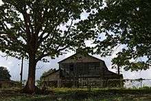
Most of the original buildings still stand, with the exception of the hospital, which was dismantled by people looking for valuables.
Water tower
Regarded as the symbol of Fordlândia, the 50-meter high water tower is located by the main warehouses. As most of the equipment in the town, it was built in Michigan and brought to Fordlândia by merchant ship. The water tower, water treatment plant and all of its original plumbing are still operational.
Hospital
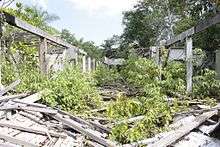
The hospital was left intact until the late 2000s, when people looking for valuables completely dismantled the hospital and stole its contents.
Before being dismantled, a number of controversies occurred regarding the hospital's X-ray machines. As a local TV station reported, several marked boxes containing radioactive material were left behind. This generated fears of contamination among the population of nearby cities, with people often mentioning the Goiânia accident, causing the authorities to remove the materials following an outcry.
Sawmill
The town had a sawmill responsible for providing lumber for all the construction around. The sawmill and kiln still stand; however, most equipment is gone.
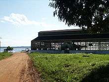
Workshop
The town's workshop was a 3-story warehouse responsible for manufacturing parts for the machines working in the town. It still stands and has most of the original equipment. It is now used as a warehouse where most artifacts from Ford's era are kept. Hospital beds, equipment, a lead coffin and parts of an X-ray machine are stored in this warehouse.
The second floor of the warehouse was allowed to be used for the processing of seeds for a community project. The oil extracted from those seeds greatly accelerated the rotting of the wooden floor which has collapsed in some areas.
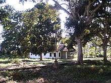
American Village
The six houses in the American Village still had their original furniture, silverware and even clothes that were left behind when the town was deserted. The houses were claimed by locals and most items were sold or taken as souvenir. One of the houses was lost to a fire.
Legacy and depictions
- The future London in Brave New World by Aldous Huxley is heavily inspired by the concept of Fordlândia.
- The 6th installment of the Franco-Belgian comic series Marsupilami by Yann and Batem, published in 1991, is titled "Fordlandia" and takes place there.
- Singer/songwriter Kate Campbell has a track entitled "Fordlândia" on her 2008 album Save the Day.
- Argentinian writer Eduardo Sguiglia wrote a novel entitled Fordlandia.
- In November 2008, Icelandic composer Jóhann Jóhannsson released an album entitled Fordlandia.
- In 2009, Greg Grandin published his non-fiction account Fordlandia: The Rise and Fall of Henry Ford's Forgotten Jungle City, and Montreal artist Scott Chandler photographed Fordlândia.[5]
- German television production company Gebrüder Beetz included Fordlândia in episode 4 of their 5-part series Modern Ruins.[6]
- British artist Dan Dubowitz photographed Fordlândia in 2012.[7]
- British actor and comedian Michael Palin's 4-part TV travel documentary Brazil with Michael Palin featured Fordlândia in episode 2 shown on BBC1 on 31 October 2012.
- In the PC game The Amazon Trail, the player travels back in time to meet Henry Ford there.
- American author Buell Hollister explores Fordlândia's history and uses the area as the setting in his 2015 novel Leeram in Fordlandia.
Notes and references
- ↑ Dempsey, Mary A. (1994). "Fordlandia". Michigan History. 78 (4): 24–33.
- ↑ Grandin, Greg (June 2009). Fordlandia: The Rise and Fall of Henry Ford's Forgotten Jungle City. Metropolitan Books. ISBN 978-0-8050-8236-4.
- ↑ "Rubber Plantations". Thehenryford.org. Retrieved 2013-07-24.
- ↑ Galey, John (1979). "Industrialist in the Wilderness: Henry Ford's Amazon Venture". Journal of Interamerican Studies and World Affairs. 21 (2): 261–289. ISSN 0022-1937. JSTOR 165528.
- ↑ Chandler, Scott. "Fordlandia". Retrieved 4 May 2016.
- ↑ Modern Ruins – Fordlândia | gebrueder beetz filmproduktion
- ↑ Megalomania - Fordlandia | Dan Dubowitz / Civic Works
Bibliography
- (French) Michel Braudeau, « Henry Ford vaincu par la « rouille » », in Le rêve amazonien, éditions Gallimard, 2004 (ISBN 2-07-077049-4).
See also
External links
| Wikimedia Commons has media related to Fordlândia. |
- The Ruins of Fordlândia, by Alan Bellows, from Damn Interesting, posted 3 August 2006. Includes pictures.
- Fordlandia: The Rise and Fall of Henry Ford’s Forgotten Jungle City - Democracy Now, broadcast 2 July 2009, Video and Discussion (transcript available).
- Fordlandia - Fordlandia: The Rise and Fall of Henry Ford’s Forgotten Jungle City, UK edition, published by Icon Books
- Fordlandia on Flickr - Historic images from the Benson Ford Research Center, a library and archive located at the Henry Ford Museum.
Coordinates: 3°49′53″S 55°29′51″W / 3.83139°S 55.49750°W