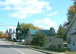
Fort Covington, New York
| Fort Covington, New York | |
|---|---|
| Town | |
 | |
 Fort Covington Location within the state of New York | |
| Coordinates: 44°57′51″N 74°30′7″W / 44.96417°N 74.50194°W | |
| Country | United States |
| State | New York |
| County | Franklin |
| Government | |
| • Type | Town Council |
| • Town Supervisor | Patricia Manchester (D) |
| • Town Council |
Members' List
|
| Area | |
| • Total | 36.7 sq mi (95.1 km2) |
| • Land | 36.7 sq mi (95.1 km2) |
| • Water | 0.0 sq mi (0.0 km2) |
| Elevation | 187 ft (57 m) |
| Population (2010) | |
| • Total | 1,676 |
| • Density | 17.6/sq mi (6.8/km2) |
| Time zone | Eastern (EST) (UTC-5) |
| • Summer (DST) | EDT (UTC-4) |
| ZIP code | 12937 |
| Area code(s) | 518 |
| FIPS code | 36-26737 |
| GNIS feature ID | 0978966 |
Fort Covington is a town in Franklin County, New York. The population was 1,676 at the 2010 census.[1] The name is derived from a War of 1812 fortification. The original name of the town was "French Mills".
The town is on the county's northern border, which is also the Canada–United States border.
History
Many of the early settlers were from Canada and Vermont, and the town was settled before 1800. In July 1813 a blockhouse was built here to shelter wounded soldiers and to provide a winter headquarters. The fort was named after General Leonard Covington,[2] a casualty of the War of 1812.
The town of Fort Covington was formed in 1817 from the town of Constable. In 1833, the west part of Fort Covington was made into the town of Bombay.
The Fort Covington–Dundee Border Crossing was listed on the National Register of Historic Places in 2014 as the U.S. Inspection Station–Fort Covington, New York.[3]
Geography
Fort Covington is in northwestern Franklin County, in northern New York. It is bordered to the west by the St. Regis Mohawk Reservation. The north town line is the international border with Canada (province of Quebec). According to the United States Census Bureau, the town has a total area of 36.7 square miles (95.1 km2), all land.[1]
New York State Route 37 crosses the middle of the town, leading west to Massena and southeast to Malone.
Quebec Route 132 serves the area via Dundee Road and Water Street.
Demographics
| Historical population | |||
|---|---|---|---|
| Census | Pop. | %± | |
| 1820 | 979 | — | |
| 1830 | 2,901 | 196.3% | |
| 1840 | 2,094 | −27.8% | |
| 1850 | 2,641 | 26.1% | |
| 1860 | 2,757 | 4.4% | |
| 1870 | 2,436 | −11.6% | |
| 1880 | 2,424 | −0.5% | |
| 1890 | 2,207 | −9.0% | |
| 1900 | 2,043 | −7.4% | |
| 1910 | 2,028 | −0.7% | |
| 1920 | 1,966 | −3.1% | |
| 1930 | 1,728 | −12.1% | |
| 1940 | 1,767 | 2.3% | |
| 1950 | 1,764 | −0.2% | |
| 1960 | 1,905 | 8.0% | |
| 1970 | 1,963 | 3.0% | |
| 1980 | 1,804 | −8.1% | |
| 1990 | 1,676 | −7.1% | |
| 2000 | 1,645 | −1.8% | |
| 2010 | 1,676 | 1.9% | |
| Est. 2014 | 1,650 | [4] | −1.6% |
As of the census[6] of 2000, there were 1,645 people, 621 households, and 466 families residing in the town. The population density was 44.8 people per square mile (17.3/km²). There were 706 housing units at an average density of 19.2 per square mile (7.4/km²). The racial makeup of the town was 87.13% White, 0.36% African American, 10.81% Native American, 0.55% Asian, 0.30% from other races, and 0.85% from two or more races. Hispanic or Latino of any race were 1.22% of the population.
There were 621 households out of which 34.0% had children under the age of 18 living with them, 59.4% were married couples living together, 10.1% had a female householder with no husband present, and 24.8% were non-families. 21.1% of all households were made up of individuals and 11.1% had someone living alone who was 65 years of age or older. The average household size was 2.65 and the average family size was 3.03.
In the town the population was spread out with 26.7% under the age of 18, 6.9% from 18 to 24, 26.5% from 25 to 44, 25.2% from 45 to 64, and 14.7% who were 65 years of age or older. The median age was 39 years. For every 100 females there were 90.8 males. For every 100 females age 18 and over, there were 92.5 males.
The median income for a household in the town was $31,532, and the median income for a family was $39,205. Males had a median income of $26,369 versus $22,011 for females. The per capita income for the town was $14,932. About 10.3% of families and 14.7% of the population were below the poverty line, including 19.3% of those under age 18 and 13.9% of those age 65 or over.
Communities and locations in Fort Covington
- Cooks Corner – A hamlet by the south town line at the junction of County Roads 3 and 32.
- Fort Covington – The hamlet of Fort Covington was once a village within the town, incorporated in 1889, but later abandoned that status in 1976. The community is located at the junction of NY-37 and County Road 42 and is a port of entry. The area around the hamlet comprising the northern half of the entire town is now listed as the Fort Covington Hamlet census-designated place.
- Fort Covington Center – A hamlet near the south town line on County Road 42.
- Pike Creek – A stream flowing northward through the town toward the St. Lawrence River.
- Salmon River – A stream flowing through the town.
Notable locals
- George Hyer, Wisconsin newspaperman, farmer and politician
- A. Warren Phelps, Wisconsin businessman and politician
References
- 1 2 "Geographic Identifiers: 2010 Census Summary File 1 (G001), Fort Covington town, Franklin County, New York". American FactFinder. U.S. Census Bureau. Retrieved June 13, 2016.
- ↑ Gannett, Henry (1905). The Origin of Certain Place Names in the United States. Govt. Print. Off. p. 128.
- ↑ "National Register of Historic Places listings for September 19, 2014". U.S. National Park Service. September 19, 2014. Retrieved September 20, 2014.
- ↑ "Annual Estimates of the Resident Population for Incorporated Places: April 1, 2010 to July 1, 2014". Retrieved June 4, 2015.
- ↑ "Census of Population and Housing". Census.gov. Retrieved June 4, 2015.
- ↑ "American FactFinder". United States Census Bureau. Retrieved 2008-01-31.
External links
Coordinates: 44°59′21″N 74°29′41″W / 44.98917°N 74.49472°W
Municipalities and communities of Franklin County, New York, United States | ||
|---|---|---|
| Towns | 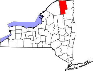 | |
| Villages | ||
| CDPs | ||
| Hamlets | ||
| Indian reservation | ||
| Footnotes | ‡This populated place also has portions in an adjacent county or counties | |