Franciscus Haraeus
Franciscus Haraeus (Latinised form of Franciscus Verhaer; also known as Frans Verhaer),[1] (Utrecht 1555? - Leuven, 11 January 1631), was a "Netherlandish"[2] theologian, historian, and cartographer. He is best known for his history (from a Catholic point of view) of the Dutch Revolt. He was one of the first cartographers who made thematic maps and globes.
Life
Haraeus first attended the Latin school of the Brethren of the Common Life in Utrecht and subsequently studied theology at the University of Louvain under Thomas Stapleton and Johannes Molanus.[3]:172 He was ordained a Roman Catholic priest at an early age, probably in 1578. He was appointed as a professor of rhetoric at the then-new University of Douai where he also obtained a Licentiate of Theology. In 1581 he accompanied the papal legate Possevin on an embassy to John III of Sweden and Ivan the Terrible.[4]:165[5]:529
Back in the Dutch Republic he became a canon at St. John's Cathedral ('s-Hertogenbosch), later dean in Duinkerken and professor of theology at Tongerlo Abbey. In 1604-1609 he worked as a priest in Utrecht where he was in contact with Buchelius. After 1609 he moved permanently to the Spanish Netherlands where he became the rector of a nunnery in Antwerp, before becoming a canon in Namur in 1617, and after 1621 in Leuven.[3]:172 He died in the latter city on 11 January 1631,[6] and was buried in the St. Peter Church in Leuven, near the tomb of Thomas Stapleton.[4]:165
Historical works
Haraeus wrote (or maybe better, compiled) a large number of hagiographies. However, his historical works of longer lasting import concerned the first part of the Eighty Years' War through which he had lived himself. He took clearly the side of king Philip II of Spain against William the Silent which gave his work a polemical and sometimes biased character. His first publication in this field was Onpartijdighe Verklaringhe der oorsaken der Nederlantsche oorloghs sedert 't jaer 1566 tot 1608[7] (Antwerp 1612). This provoked a critical reply by the Dutch-Supreme-Court Justice François Vranck, entitled: Wederlegghinghe van een seker Boecxke uytghegheven bij Franchois Verhaer, ghenaemt onpartijdighe verclaringhe der oorsaken van de Nederlantsche Oorloghe, sedert den Jare 1566 tot ten Jare 1608 toe[8](published posthumously, 1618). Meanwhile, Haraeus had already started on his major history: Annales ducum seu principum Brabantiae totiusque Belgii tomi tres: quorum primo solius Brabantiae, secundo Belgii uniti principum res gestae, tertio Belgici tumultus usque ad inductas anno MDCIX pactas, enarrantur[9] (Antwerp 1623). This work was well received in the Spanish Netherlands where it long was a "best seller," not so much because of its originality, but because of its tenor. The third volume was reworked by its author, but this version only exists in manuscript; it was never printed.[5]:530
Cartographic work[10]
Haraeus was one of several clergymen from the Netherlands who around the turn of the 17th century made important contributions to the young science of map-making (another one was Petrus Plancius). He was one of the three cartographers in the Spanish Netherlands who kept the craft of globe-making alive there after the exodus of many cartographers around the turn of the 17th century.[11] In 1614 he published a six-gore map entitled Novus typus orbis ipsus globus, ex Analemmate Ptolomaei diductus[12] This was one of the first instances of a thematic map as it showed the dispersion of Christianity and Islam at the time, using map symbols developed by Jodocus Hondius in his Designatio Orbis Christiani (1607)[13][14]
In 1624 a map entitled Lumen Historiarum per Orientem[15] was published by Balthasar Moretus as part of a new edition of Ortelius' Theatrum orbis terrarum Parergon[16] which recognized Haraeus as its maker.[17] This map was part of a set of two made earlier by Haraeus and designed as a catchall guide to sacred geography.[18]
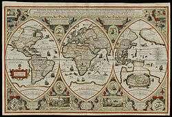
As a final example, Haraeus Geographica restituta per globi trientes [19] (1618; see the illustration above) shows the world in three globe-gores. Note the insets: there is a map representing the 2nd-century worldview of Ptolemy in the lower-Eastern section, and a legend for the map in the lower-center, explaining symbols which identify religious habitations (a cross for Christian regions, a crescent for Islam, and a slanted arrow for barbarians).[20]
Notes and references
- ↑ B.A. Vermaseren. De katholieke nederlandsche geschiedschrijving. p 223
- ↑ He was born in the still undivided Habsburg Netherlands in a part that would become the Dutch Republic, but spent a large part of his life in the Spanish Netherlands that would later become Belgium; both The Netherlands and Belgium could therefore claim him.
- 1 2 Haitsma Mulier, E.O.G. and Anton van der Lem (eds.) (1990). "Repertorium van Geschiedschrijvers in Nederland 1500-1800". The Hague. Retrieved 25 February 2013.
- 1 2 Van der Aa, A.J. (1867). "Biographisch woordenboek der Nederlanden, deel 8-1". Retrieved 25 February 2013.
- 1 2 Molhuysen, P.C and P.J. Blok (eds.) (1927). "Nieuw Nederlandsch Biografisch Woordenboek,deel 7". Sijthoff, Leiden. Retrieved 24 February 2013.
- ↑ According to both Van der Aa and Molhuyzen/Blok he died in 1632 but more modern sources like Haitsma Mulier give 1631 as year of death.
- ↑ Impartial explanation of the causes of the Dutch war since the year 1566 till 1608.
- ↑ Refutation of a certain booklet published by Franchois Verhaer, entitled ... etc.
- ↑ Annals of the dukes or princes of Brabant and the entire Netherlands in three volumes: which are firstly Brabant alone, secondly the acts of the Prince of the united Netherlands, thirdly the Dutch troubles all the way up to the adventitious 1609 treaty, which they explain in detail.
- ↑ Van der Krogt, Peter C.J. and Günter Schilder (1984). Het kartografische Werk van de Theoloog-Historicus Franciscus Haraeus (ca. 1555-1631) Annalen van de Koninklijke Oudheidkundige Kring van het Land van Waas.
- ↑ Van der Krogt, P.C.J. "Globi Neerlandici: De globeproduktie in de Nederlanden". Utrecht Cartography Dissertations 1989. Retrieved 25 February 2013.
- ↑ New image of the world as a globe, derived from the Analemmata of Ptolemy.
- ↑ Outmapping of the Christian World.
- ↑ "Novus typus orbis ipsus globus, ex Analemmate Ptolomaei diductus 1614". Retrieved 25 February 2013.
- ↑ Light of histories over the East.
- ↑ Appendix to Theatrum orbis terrarum or Theater of the Lands of the World.
- ↑ "Lumen Historiarum per Orientem". Retrieved 25 February 2013.
- ↑ Shalev, Zur (2011). Sacred Words and Worlds: Geography, Religion, and Scholarship, 1550-1700. Brill. pp. 233–234.
- ↑ Geography set up by thirds of a globe.
- ↑ Norman B. Leventhal map center. "Geographica restituta per globi trientes". Retrieved 25 February 2013.