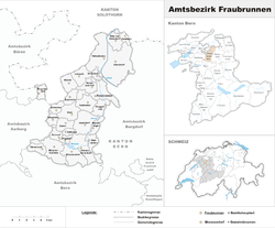
Fraubrunnen District
| Fraubrunnen District Amtsbezirk Fraubrunnen | |
|---|---|
| District | |
 | |
| Country |
|
| Canton |
|
| Capital | Fraubrunnen |
| Area | |
| • Total | 124 km2 (48 sq mi) |
| Population (2007) | |
| • Total | 38,895 |
| • Density | 310/km2 (810/sq mi) |
| Time zone | CET (UTC+1) |
| • Summer (DST) | CEST (UTC+2) |
| Municipalities | 26 |
Fraubrunnen District was one of the 26 administrative districts in the canton of Bern, Switzerland. Its capital was the municipality of Fraubrunnen. The district has an area of 124 km² and consists of 27 municipalities:
| Municipality | Population (Jan 2005) | Area (km²) |
|---|---|---|
| Bangerten | 163 | 2.2 |
| Bätterkinden | 2,780 | 10.1 |
| Büren zum Hof | 455 | 3.5 |
| Deisswil bei Münchenbuchsee | 80 | 2.1 |
| Diemerswil | 185 | 2.8 |
| Etzelkofen | 350 | 2.8 |
| Fraubrunnen | 1,691 | 7.7 |
| Grafenried | 912 | 4.7 |
| Iffwil | 399 | 5.0 |
| Jegenstorf | 4,508a | 8.9 |
| Limpach | 327 | 4.4 |
| Mattstetten | 565 | 3.8 |
| Moosseedorf | 3,437 | 6.3 |
| Mülchi | 250 | 3.8 |
| Münchenbuchsee | 9,519 | 8.9 |
| Münchringen | 544 | 2.4 |
| Ruppoldsried | 256 | 2.2 |
| Schalunen | 378 | 1.4 |
| Scheunen | 71 | 2. |
| Urtenen-Schönbühl | 5,337 | 7.2 |
| Utzenstorf | 3,763 | 17.0 |
| Wiggiswil | 95 | 1.4 |
| Wiler bei Utzenstorf | 794 | 3.8 |
| Zauggenried | 314 | 3.7 |
| Zielebach | 337 | 1.9 |
| Zuzwil | 504 | 3.5 |
- ^a Population is as of December 2007, includes population and area of Ballmoos which merged into Jegenstorf in 2010
Coordinates: 47°06′N 7°30′E / 47.1°N 7.5°E
This article is issued from Wikipedia - version of the 3/12/2013. The text is available under the Creative Commons Attribution/Share Alike but additional terms may apply for the media files.