Froissy (La Neuville-lès-Bray)
| Froissy | |
|---|---|
| Village | |
|
| |
 Froissy | |
| Coordinates: 49°55′22.08″N 2°43′33.13″E / 49.9228000°N 2.7258694°ECoordinates: 49°55′22.08″N 2°43′33.13″E / 49.9228000°N 2.7258694°E | |
| Country |
|
| Region |
|
| Department | Somme |
| Arrondissement | Péronne |
| Canton | Bray-sur-Somme |
| Intercommunality | Pays du Coquelicot |
| Municipality | La Neuville-lès-Bray |
| Elevation | 80 m (260 ft) |
| Time zone | CET (UTC+1) |
| • Summer (DST) | CEST (UTC+2) |
| Postal code | 80340 |
Froissy is a French village and hameau, part of the municipality (commune) of La Neuville-lès-Bray, in the department of Somme, Picardy.
Geography
The village is located in a meander of the River Somme, few km in south of La Neuville-lès-Bray and Bray-sur-Somme. It is crossed in the middle by the Canal de la Somme and, in south-east of it, is located a railway station of a touristic railway. Froissy is 13 km far from Albert, 27 from Péronne, 44 from Amiens, 109 from Lille and 150 from Paris.
Village's main roads are the Route de Roye, part of the D329 departmental road, and Rue du Port, running through the northern shore of the canal.
Main sights
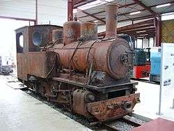
Froissy is the western terminus of the Froissy Dompierre Light Railway (also named P'tit Train de la Haute Somme), a heritage and touristic narrow gauge railway. In Froissy station is located a museum, the Musée des chemins de fer Militaires et Industriels[1] (Military and Industrial railways Museum).
References
External links
![]() Media related to Froissy at Wikimedia Commons
Media related to Froissy at Wikimedia Commons