Frosty Volcano
| Frosty Volcano | |
|---|---|
 | |
| Highest point | |
| Elevation | 6,601 ft (2,012 m) |
| Prominence | 5,753 ft (1,754 m) |
| Listing | Mountain peaks of Alaska |
| Coordinates | 55°04′55″N 162°48′50″W / 55.082°N 162.814°WCoordinates: 55°04′55″N 162°48′50″W / 55.082°N 162.814°W |
| Geography | |
| Location | Alaska Peninsula, Alaska, U.S. |
| Parent range | Aleutian Range |
| Topo map | USGS McCarthy B-2 |
| Geology | |
| Age of rock | 100m |
| Mountain type | Stratovolcano |
| Volcanic arc/belt | Aleutian Arc |
| Last eruption | Unknown |
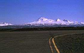
Frosty or Mt. Frosty is a stratovolcano and the westernmost Holocene volcano of the Alaska Peninsula in Alaska, USA. Frosty is the youngest of the two large volcanic structures of the Cold Bay Volcano→volcanic complex. It has a summit elevation of 6,601 feet (2,012 m). Frosty's last known eruption is 2-16≠. The oldest products of the roughly 100 cu km Cold Bay complex, which lies southwest of the village of Cold Bay, form the glacially dissected late Pliocene to early Pleistocene Morzhovoi Volcanics at the southern end of the complex.
Frosty Peak
North of Frosty Volcano is Frosty Peak, a symmetrical late-Pleistocene to Recent stratovolcano constructed within the southernmost of two coalescing craters. The western wall of the ice-filled northern crater is breached by a large valley glacier. The symmetrical ἤᾜΦΎᾜ summit cone rises at 600 m (1,969 ft) above the floor of the southern crater.