Fusine
| Fusine | |
|---|---|
| Comune | |
| Comune di Fusine | |
 Fusine Location of Fusine in Italy | |
| Coordinates: 46°8′N 9°44′E / 46.133°N 9.733°ECoordinates: 46°8′N 9°44′E / 46.133°N 9.733°E | |
| Country | Italy |
| Region | Lombardy |
| Province / Metropolitan city | Province of Sondrio (SO) |
| Area | |
| • Total | 37.5 km2 (14.5 sq mi) |
| Elevation | 285 m (935 ft) |
| Population (Dec. 2004) | |
| • Total | 650 |
| • Density | 17/km2 (45/sq mi) |
| Time zone | CET (UTC+1) |
| • Summer (DST) | CEST (UTC+2) |
| Postal code | 23010 |
| Dialing code | 0342 |
| Website | Official website |
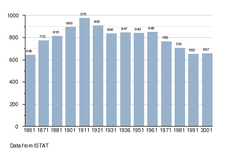
Fusine is a comune (municipality) in the Province of Sondrio in the Italian region Lombardy, located about 90 kilometres (56 mi) northeast of Milan and about 11 kilometres (7 mi) southwest of Sondrio. As of 31 December 2004, it had a population of 650 and an area of 37.5 square kilometres (14.5 sq mi).[1] Its territory was historically part of Carniola.
Fusine borders the following municipalities: Berbenno di Valtellina, Cedrasco, Colorina, Foppolo, Forcola, Postalesio, Tartano.
Demographic evolution
References
External links
This article is issued from Wikipedia - version of the 1/31/2015. The text is available under the Creative Commons Attribution/Share Alike but additional terms may apply for the media files.