Gölsen
| Gölsen | |
|---|---|
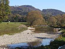 The gravel banks of the Gölsen | |
| Country | Austria |
| Basin | |
| Main source |
Hainfeld 439 m (1,440 ft) |
| River mouth | The Traisen River at Traisen. |
| Physical characteristics | |
| Length | 15 km (9.3 mi) |
The Gölsen is a tributary of the Traisen that is located in the Lower Austrian region of Mostviertel.
The river begins in Hainfeld with the merging of the Fliedersbach and the Ramsaubach (also called the Innere Gölsen). It then flows through the communities of Hainfeld, Rohrbach an der Gölsen, and Sankt Veit an der Gölsen, before meeting the Traisen at Traisen. The Gölsen flows in an east-west direction and is only around 15 km long with a difference in elevation of 80 meters.
On account of its constantly returning high water, the Gölsen is now very carefully controlled (the Gölsen Dam, etc.). Within its wide river bed however, the river can create gravel banks.
Parallel to the river runs the so-called Gölsentalradweg ("Gölsen valley bike trail"), which runs from the Traisentalradweg to Hainfeld. An extension of the path to the Triesting Valley Cycle Way is planned.
Along the Gölsen runs a rail line, the Leoberdorf Railway, from Traisen to Hainfeld. In the past, the line was longer and continued to Kaumberg and farther into the Triesting Valley. Since 2004, however, there have only been special trains in the Summer on this section of rail.
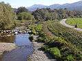 Gölsen at Wiesenfeld
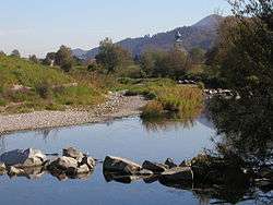 Gölsen at Sankt Veit
References
| Wikimedia Commons has media related to Gölsen. |
- The information in this article is based on a translation of its German equivalent.
Coordinates: 48°03′N 15°36′E / 48.050°N 15.600°E