Gallipolis Ferry, West Virginia
| Gallipolis Ferry, West Virginia | |
|---|---|
| Census-designated place | |
 Gallipolis Ferry, West Virginia | |
| Coordinates: 38°46′14″N 82°11′56″W / 38.77056°N 82.19889°W | |
| Country | United States |
| State | West Virginia |
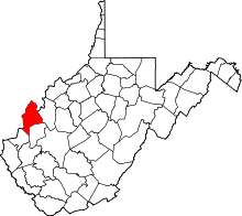
| County | Mason |
| Area[1] | |
| • Total | 2.771 sq mi (7.18 km2) |
| • Land | 2.275 sq mi (5.89 km2) |
| • Water | 0.496 sq mi (1.28 km2) |
| Elevation | 594 ft (181 m) |
| Population (2010)[2] | |
| • Total | 817 |
| • Density | 290/sq mi (110/km2) |
| Time zone | Eastern (EST) (UTC-5) |
| • Summer (DST) | EDT (UTC-4) |
| ZIP code | 25515 |
| Area code(s) | 304 & 681 |
| GNIS feature ID | 1554524[3] |
Gallipolis Ferry is a census-designated place (CDP) in Mason County, West Virginia, USA. It is situated on the Ohio River along West Virginia Route 2. As of the 2010 census, its population was 817.[2] It is the site of the Robert C. Byrd Locks & Dam on the Ohio. The community was named for the fact a ferry once provided service between the town site and nearby Gallipolis, Ohio.[4]
The community is part of the Point Pleasant, WV–OH Micropolitan Statistical Area.
References
- ↑ "US Gazetteer files: 2010, 2000, and 1990". United States Census Bureau. 2011-02-12. Retrieved 2011-04-23.
- 1 2 "American FactFinder". United States Census Bureau. Retrieved 2011-05-14.
- ↑ U.S. Geological Survey Geographic Names Information System: Gallipolis Ferry, West Virginia
- ↑ Kenny, Hamill (1945). West Virginia Place Names: Their Origin and Meaning, Including the Nomenclature of the Streams and Mountains. Piedmont, WV: The Place Name Press. p. 258.
Coordinates: 38°46′14″N 82°11′56″W / 38.77056°N 82.19889°W
This article is issued from Wikipedia - version of the 9/4/2016. The text is available under the Creative Commons Attribution/Share Alike but additional terms may apply for the media files.