Gallus (Frankfurt am Main)
| Gallus | |
|---|---|
| Stadtteil of Frankfurt am Main | |
 Gallus | |
Location of the Gallus (red) and the Ortsbezirk Innenstadt I (light red) within Frankfurt am Main 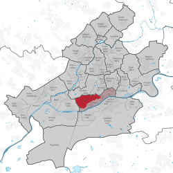 | |
| Coordinates: 50°06′13″N 08°38′44″E / 50.10361°N 8.64556°ECoordinates: 50°06′13″N 08°38′44″E / 50.10361°N 8.64556°E | |
| Country | Germany |
| State | Hesse |
| Admin. region | Darmstadt |
| District | Urban district |
| Town | Frankfurt am Main |
| Area | |
| • Total | 4.301 km2 (1.661 sq mi) |
| Population (2007-12-31) | |
| • Total | 25,843 |
| • Density | 6,000/km2 (16,000/sq mi) |
| Time zone | CET/CEST (UTC+1/+2) |
| Postal codes | 60326, 60487 |
| Dialling codes | 069 |
| Vehicle registration | F |
| Website | www.frankfurt.de |
The Gallus (known as the Gallusviertel until 2007) is a city district of Frankfurt am Main, Germany. It is part of the Ortsbezirk Innenstadt I.
The name Gallus originates from the German word "Galgen" (English: Gallows).
Gallus extends in the west to Griesheim, while it is bordered in the north by the exhibition center and the Rebstockpark and in the south by the railway tracks. An important transport and business axis, Mainzer Landstraße, which is bordered by car dealers, gas stations and office buildings, cuts directly across the entire city section. On the grounds of the former freight depot and marshaling yard all around Den Haager Straße, a completely new residential and retail district is currently being developed-the Europaviertel. During World War II, the Alderwerke factory was a concentration camp, using slave labour from the Natzweiler-Struthof concentration camp, and after the War the area was also host to the Frankfurt Auschwitz Trials during 1963-65. By 2019, offices, stores and apartments are to be built on the 90 hectare large grounds. The Mövenpick Hotel Frankfurt City has been there since 2006.