Gamble Township, Lycoming County, Pennsylvania
| Gamble Township, Pennsylvania | |
|---|---|
| Township | |
|
Rose Valley Lake | |
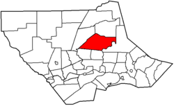
 Map of Lycoming County, Pennsylvania highlighting Gamble Township | |
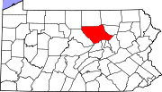
 Map of Lycoming County, Pennsylvania | |
| Coordinates: 41°23′42″N 76°57′27″W / 41.39500°N 76.95750°WCoordinates: 41°23′42″N 76°57′27″W / 41.39500°N 76.95750°W | |
| Country | United States |
| State | Pennsylvania |
| County | Lycoming |
| Settled | 1794 |
| Formed | 1875 |
| Area | |
| • Total | 46.2 sq mi (119.5 km2) |
| • Land | 45.5 sq mi (117.9 km2) |
| • Water | 0.7 sq mi (1.6 km2) |
| Elevation | 1,316 ft (401 m) |
| Population (2000) | |
| • Total | 854 |
| • Density | 18.8/sq mi (7.2/km2) |
| Time zone | Eastern Time Zone (North America) (UTC-5) |
| • Summer (DST) | EDT (UTC-4) |
| ZIP code | 17771 |
| Area code(s) | 570 |
| FIPS code | 42-28352[1] |
| GNIS feature ID | 1216750[2] |
Gamble Township is a township in Lycoming County, Pennsylvania, United States. The population was 854 at the 2000 census. It is part of the Williamsport, Pennsylvania Metropolitan Statistical Area.
History
Gamble Township was formed from parts of Lewis and Cascade Townships on January 30, 1875. An election of the citizens of the proposed township was 152-0 in favor of its creation. The drive for the formation of Gamble Township was led Ira Parker, Abraham Swartz, and J.C. Green. They started a petition and gathered the necessary signatures. Their petition was presented to Judge James Gamble who authorized the election. The results of the balloting were certified by Judge Huston Hepburn. The township is named for the judge who ordered the election.[3]
The first settler in Gamble Township was John Rose, for who Rose Valley is named. Rose was born in Scotland in 1772. He migrated to the United States in 1794 and settled in what is now Gamble Township. Rose was accompanied to the valley by is first wife and a man named Andrew Tulloh. Rose and Tulloh cleared some land for farming but did not remain in the valley. They both moved to Williamsport in their later years. The departure of John Rose did not bring about the end of agricultural development in Gamble Township. New settlers, a majority of them Germans, continued to clear Rose Valley. Here they established dairy farms and orchards, some of which are thriving today.
Salt mining and the lumbering were the primary industries found in Gamble Township during the mid-to-late 19th century. Several salt mines were built within the township. Thousands of acres of old-growth forest were cleared to meet the demands for lumber during the lumber era that swept throughout Pennsylvania. Williamsport, which is just south of Gamble Township, was known at the "Lumber Capital of the World."
Today Gamble Township is a largely rural area with scattered dairy farms, orchards, and family homes. The population has risen by just 100 since the 1890 census when count stood at 754.
Geography
Gamble Township is bordered by Lewis Township to the northwest, Cascade Township to the north, Plunketts Creek Township to the east and southeast, and Hepburn and Eldred Townships to the south.[4] As the crow flies, Lycoming County is about 130 miles (209 km) northwest of Philadelphia and 165 miles (266 km) east-northeast of Pittsburgh.
According to the United States Census Bureau, the township has a total area of 46.2 square miles (120 km2).45.5 square miles (117.9 km2) of it is land and 0.6 square miles (1.6 km2) of it (1.37%) is water.
Rose Valley Lake is a reservoir that covers 389 acres (1.57 km2) in Gamble Township. The fish and waters of the lake are managed by the Pennsylvania Fish and Boat Commission. The lake is owned by the Commonwealth of Pennsylvania. Its primary use is recreational game fishing. The lake is open for recreational fishing on a year-round basis. Ice fishing is permitted, but the thickness of the ice is not monitored by the Fish Commission. The most common game species of fish in the lake are, largemouth bass, bluegill, black crappie, muskellunge, yellow perch, chain pickerel, pumpkinseed and walleye. The lake is five miles east of U.S. Route 15 and Pennsylvania Route 14. It can be reached by taking Trout Run Mountain Road to Rose Valley Mountain Road.[5]
Demographics
As of the census[1] of 2000, there were 854 people, 320 households, and 254 families residing in the township. The population density was 18.8 people per square mile (7.2/km2). There were 382 housing units at an average density of 8.4/sq mi (3.2/km2). The racial makeup of the township was 99.65% White, 0.12% Native American, 0.12% Asian, 0.12% from other races. Hispanic or Latino of any race were 0.12% of the population.
There were 320 households, out of which 29.4% had children under the age of 18 living with them, 70.9% were married couples living together, 5.6% had a female householder with no husband present, and 20.6% were non-families. 17.2% of all households were made up of individuals, and 6.6% had someone living alone who was 65 years of age or older. The average household size was 2.67 and the average family size was 3.02.
In the township the population was spread out, with 22.8% under the age of 18, 7.4% from 18 to 24, 27.6% from 25 to 44, 30.4% from 45 to 64, and 11.7% who were 65 years of age or older. The median age was 41 years. For every 100 females there were 105.8 males. For every 100 females age 18 and over, there were 103.4 males.
The median income for a household in the township was $39,028, and the median income for a family was $42,054. Males had a median income of $31,705 versus $20,000 for females. The per capita income for the township was $18,867. About 8.1% of families and 9.1% of the population were below the poverty line, including 12.6% of those under age 18 and 7.3% of those age 65 or over.
References
- 1 2 "American FactFinder". United States Census Bureau. Retrieved 2008-01-31.
- ↑ "US Board on Geographic Names". United States Geological Survey. 2007-10-25. Retrieved 2008-01-31.
- ↑ Meginness, John Franklin (1892). "Plunkett's Creek, Lewis, Cascade, and Gamble". History of Lycoming County, Pennsylvania: including its aboriginal history; the colonial and revolutionary periods; early settlement and subsequent growth; organization and civil administration; the legal and medical professions; internal improvement; past and present history of Williamsport; manufacturing and lumber interests; religious, educational, and social development; geology and agriculture; military record; sketches of boroughs, townships, and villages; portraits and biographies of pioneers and representative citizens, etc. etc. (1st ed.). Chicago: Brown, Runk & Co. ISBN 0-7884-0428-8. Retrieved 2007-04-09.
(Note: ISBN refers to Heritage Books July 1996 reprint. URL is to a scan of the 1892 version with some OCR typos).
- ↑ "2007 General Highway Map Lycoming County Pennsylvania" (PDF) (Map). 1:65,000. Pennsylvania Department of Transportation, Bureau of Planning and Research, Geographic Information Division. Retrieved 2009-12-24.
- ↑ "ROSE VALLEY LAKE Lycoming County". Pennsylvania Fish and Boat Commission. Retrieved 2007-04-09.