Penn Township, Lycoming County, Pennsylvania
| Penn Township, Lycoming County, Pennsylvania | |
|---|---|
| Township | |
|
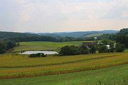
Scenery of Penn Township | |
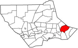 Map of Lycoming County, Pennsylvania highlighting Penn Township | |
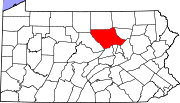 Map of Lycoming County, Pennsylvania | |
| Coordinates: 41°16′48″N 76°38′37″W / 41.28000°N 76.64361°WCoordinates: 41°16′48″N 76°38′37″W / 41.28000°N 76.64361°W | |
| Country | United States |
| State | Pennsylvania |
| County | Lycoming |
| Settled | 1774 |
| Incorporated | 1828 |
| Area | |
| • Total | 26.7 sq mi (69.2 km2) |
| • Land | 26.6 sq mi (68.8 km2) |
| • Water | 0.1 sq mi (0.4 km2) |
| Elevation[1] | 823 ft (251 m) |
| Population (2000) | |
| • Total | 900 |
| • Density | 33.9/sq mi (13.1/km2) |
| Time zone | Eastern (EST) (UTC-5) |
| • Summer (DST) | EDT (UTC-4) |
| FIPS code | 42-58848[2] |
| GNIS feature ID | 1216767[1] |
Penn Township is a township in Lycoming County, Pennsylvania, United States. The population was 900 at the 2000 census. It is part of the Williamsport, Pennsylvania Metropolitan Statistical Area.
History
Penn Township was formed in 1828 when Muncy Township was divided for the fourth time. It is named for Penn Township, Berks County, Pennsylvania in Berks County which is named for William Penn the founder of Pennsylvania. Tobias and Isaac Kepner had migrated to eastern Lycoming County from Berks County and wanted their new home to have the same name as their old home.[3] Much of the history of Penn Township can be found in the history of the Big Runaway and Muncy Township. Lumbering was the dominant industry in Penn Township during the mid-to-late 19th century. A man made lake, Beaver Lake,[4] was built to supply water power for a sawmill. The sawmill has long since disappeared but the lake remains.
Geography

Penn Township is bordered by Sullivan County to the northeast, Franklin Township to the east, Moreland Township to the south, Wolf Township and Picture Rocks to the west, and Shrewsbury Township to the northwest.[5] As the crow flies, Lycoming County is about 130 miles (209 km) northwest of Philadelphia and 165 miles (266 km) east-northeast of Pittsburgh.
According to the United States Census Bureau, the township has a total area of 26.7 square miles (69.2 km2), of which, 26.6 square miles (68.8 km2) of it is land and 0.1 square miles (0.4 km2) of it (0.52%) is water.
Demographics
As of the census[2] of 2000, there were 900 people, 349 households, and 263 families residing in the township. The population density was 33.9 people per square mile (13.1/km2). There were 420 housing units at an average density of 15.8/square mile (6.1/km2). The racial makeup of the township was 98.89% White, 0.44% Asian, and 0.67% from two or more races.
There were 349 households, out of which 33.0% had children under the age of 18 living with them, 67.6% were married couples living together, 3.7% had a female householder with no husband present, and 24.4% were non-families. 20.6% of all households were made up of individuals, and 7.7% had someone living alone who was 65 years of age or older. The average household size was 2.58 and the average family size was 3.01.
In the township the population was spread out, with 25.9% under the age of 18, 4.6% from 18 to 24, 29.4% from 25 to 44, 27.3% from 45 to 64, and 12.8% who were 65 years of age or older. The median age was 39 years. For every 100 females there were 112.3 males. For every 100 females age 18 and over, there were 109.1 males.
The median income for a household in the township was $40,735, and the median income for a family was $46,797. Males had a median income of $28,421 versus $22,000 for females. The per capita income for the township was $16,346. About 5.0% of families and 6.9% of the population were below the poverty line, including 8.1% of those under age 18 and 6.4% of those age 65 or over.
References
- 1 2 "US Board on Geographic Names". United States Geological Survey. 2007-10-25. Retrieved 2008-01-31.
- 1 2 "American FactFinder". United States Census Bureau. Retrieved 2008-01-31.
- ↑ Meginness, John Franklin (1892). "Shrewsbury, Wolf, and Penn". History of Lycoming County, Pennsylvania: including its aboriginal history; the colonial and revolutionary periods; early settlement and subsequent growth; organization and civil administration; the legal and medical professions; internal improvement; past and present history of Williamsport; manufacturing and lumber interests; religious, educational, and social development; geology and agriculture; military record; sketches of boroughs, townships, and villages; portraits and biographies of pioneers and representative citizens, etc. etc. (1st ed.). Chicago: Brown, Runk & Co. ISBN 0-7884-0428-8. Retrieved 2007-04-23.
(Note: ISBN refers to Heritage Books July 1996 reprint. URL is to a scan of the 1892 version with some OCR typos).
- ↑ United States Geological Survey. "Beaver Lake, USGS Sonestown (PA) Topo Map". TopoQuest. Retrieved 2008-06-30.
- ↑ "2007 General Highway Map Lycoming County Pennsylvania" (PDF) (Map). 1:65,000. Pennsylvania Department of Transportation, Bureau of Planning and Research, Geographic Information Division. Retrieved 2009-12-26.
Municipalities and communities of Lycoming County, Pennsylvania, United States | ||
|---|---|---|
| City | | |
| Boroughs | ||
| Townships |
| |
| CDPs | ||
| Unincorporated communities | ||
| Ghost town | ||
| Footnotes | ‡This populated place also has portions in an adjacent county | |