Terrington
| Terrington | |
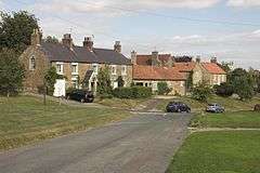 Houses at Terrington |
|
 Terrington |
|
| Population | 459 (2011) |
|---|---|
| OS grid reference | SE672706 |
| Civil parish | Terrington |
| District | Ryedale |
| Shire county | North Yorkshire |
| Region | Yorkshire and the Humber |
| Country | England |
| Sovereign state | United Kingdom |
| Post town | YORK |
| Postcode district | YO60 6 |
| Dialling code | 01653 |
| Police | North Yorkshire |
| Fire | North Yorkshire |
| Ambulance | Yorkshire |
| EU Parliament | Yorkshire and the Humber |
| UK Parliament | Thirsk and Malton |
Coordinates: 54°07′39″N 0°58′21″W / 54.127529°N 0.972630°W
Terrington is a large village and civil parish in the Ryedale district of North Yorkshire, England. It is situated in the Howardian Hills, 4 miles (6.4 km) west of Malton.
History
The village is mentioned four times in the Domesday Book as Teurintone. The lands were divided between the manors of Bulmer and Foston. At the time of the time of Norman conquest, lands in the manor were held by Ligulf, Northmann, Earl Morcar, Earl Waltheof and Gamal, son of Karli. Afterwards the lands were granted to Robert, Count of Mortain, Count Alan of Brittany and Berengar of Tosny.[1] The manor was held soon after by Niel Fossard and then followed the descent of the manor of nearby Sheriff Hutton. Other lands were tenanted in the 13th century by the Latimer family and followed the descent of his manor at Danby until the 16th century. The manor was not held in demesne like other manors. In 1427 the manor was held by the lord of Sessay manor, Edmund Darell, and remained in his family until 1752. At that time it was sold to Henry Howard, 4th Earl of Carlisle. Those lands that were part of Foston manor became the property of the Lutrell family of Appleton-le-Street.[2][3]
The village name is Old English, but of uncertain meaning. One suggestion is that it is from Tiefrung, a picture, linked to an older history of a Roman villa and mosaic floors. Another is the Anglo-Saxon name for witchcraft.[4] Lastly, it could be the combination of the Saxon personal name, Teofer, and tun, meaning Teofers farm.[5]
Governance
The village is within the Thirsk and Malton UK Parliament constituency. It is also within the Hovingham and Sheriff Hutton electoral division of North Yorkshire County Council and the Hovingham ward of Rydale District Council.[6]
The parish includes the hamlets of Wiganthorpe, Mowthorpe and Ganthorpe.
Geography
The village lies less than 1.5 miles (2.4 km) from the nearest settlements of Wiganthorpe, Dalby and Ganthorpe.[6]
Demography
In 1881, the population of the parish was recorded as 685.[3] At the 2001 census it had a population of 520 of which 51.3% were male and 48.7% female. There were 245 dwellings of which 132 were detached.[7] By the time of the 2011 Census the population had reduced to 459.[8]
Amenities
The village has many small businesses, a shop and cafe, a mobile post office and a public house (which closed in 2011). The village is served by the Malton to Scackleton bus service and seasonally by the Helmsley to Castle Howard service.[9]
Education
Primary education is provided at Terrington CE Primary School.[10] The school is within the cathment area of Malton School for secondary education.[11]
Terrington Pre-School Playgroup also provides pre-school education from 2 years to school age serving Terrington but also the surrounding villages, of Hovingham, Welburn, Slingsby and further afield. It is based at Terrington Village Hall.
The village is also home to Terrington Hall Preparatory School, a medium-sized Christian school for boys and girls aged 3 to 13, with a mixture of boarders and day pupils.[12]
Sports
The village has a tennis club, bowls club and football club. The football club have competed in the North Riding F.A. Senior Cup.[13] The village hall caters for badminton.[14]
Religion
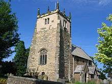
The village church is dedicated to All Saints. It has some Saxon remnants, and its site was probably a place of worship even earlier. It is a Grade I listed building.[2][3][15]
A Wesleyan chapel was built in the village in 1816 and a Primitive Methodist chapel was built in 1867.[3] The latter is now the music room of the preparatory school.[16]
References
- ↑ Terrington in the Domesday Book
- 1 2 "History". Retrieved 25 January 2013.
- 1 2 3 4 Bulmer's Topography, History and Directory (Private and Commercial) of North Yorkshire 1890. S&N Publishing. 1890. pp. 810–811. ISBN 1-86150-299-0.
- ↑ "Topynomy". Dictionary of place names. Oxford Press. Retrieved 8 February 2013.
- ↑ "Alternative topynomy". Retrieved 8 February 2013.
- 1 2 Ordnance Survey Open Viewer
- ↑ "Parish Headcounts: Ryedale". Neighbourhood Statistics. Office for National Statistics. Retrieved 6 February 2012.
- ↑ "Parish population 2011". Retrieved 11 August 2015.
- ↑ "Village Services". Retrieved 8 February 2013.
- ↑ "Primary School". Retrieved 8 February 2013.
- ↑ "Secondary education". Retrieved 8 February 2013.
- ↑ "Prep School". Retrieved 8 February 2013.
- ↑ "Football". Retrieved 8 February 2013.
- ↑ "Village Hall". Retrieved 8 February 2013.
- ↑ "Church Listing". Retrieved 8 February 2013.
- ↑ "Village History". Retrieved 8 February 2013.
External links
![]() Media related to Terrington at Wikimedia Commons
Media related to Terrington at Wikimedia Commons