Howardian Hills
| Howardian Hills | |
|---|---|
| Area of Outstanding Natural Beauty | |
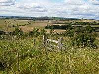 View of the Howardian Hills | |
| Country | England |
| County | North Yorkshire |
| Location | Yorkshire and the Humber |
| Area | 204 km2 (79 sq mi) |
| Highest point | Yearsley Cross |
| - elevation | 174 m (571 ft) |
| Founded | 1987 |
 Location of the Howardian Hills AONB in the UK | |
| Website : http://www.howardianhills.org.uk/ | |
The Howardian Hills take their name from the Howard family who still own local lands, and are located between the Yorkshire Wolds, the North York Moors National Park and the Vale of York. The Howardian Hills are a designated Area of Outstanding Natural Beauty (AONB); one of 46 areas in England, Wales and Northern Ireland which, along with National Parks and Heritage Coasts, represent some of the most spectacular and unspoilt landscapes in the country.
Topography
The Howardian Hills form 79 square miles of well-wooded undulating countryside between the flat agricultural Vales of Pickering and York. The irregular 558 feet (170 m) high ridges of the Howardian Hills are a southern extension of the rocks of the Hambleton Hills in the North York Moors. Jurassic limestone and a network of pasture, extensive woodland, trees and woodland combine to create a strong visual character in the higher ground overlooking the agricultural plains below. On the eastern edge, the River Derwent cuts through the Hills in the Kirkham Gorge, a deep winding valley formed as an overflow channel from glacial Lake Pickering.[1][2]
Settlement
Although there are no towns within the AONB, the market towns of Helmsley and Malton lie just beyond the boundary. From Malton to Hovingham is a line of spring line villages. The majority of older buildings are of locally quarried limestone with red pantile roofs and those which developed as part of the grand country house estates have largely retained a coherent identity.
Land use

High grade arable land, pasture and managed woodland makes this rich farming country whose diversity contributes to its attractive rural character.[1][3]
Flora and fauna
The Howardian Hills AONB is a key area for several nationally important Biodiversity Action Plan (BAP) Priority habitats including lowland broadleaved woodland, wood pasture, veteran trees, limestone and neutral grasslands and fen meadows. Characteristic species include brown hare, lapwing, tree sparrow and barn owl as well as several local rarities such as knapweed broomrape and baneberry..
Howardian Hills Area of Outstanding Natural Beauty
The Howardian Hills are designated an AONB because of the following Special Qualities:
- Unusual landform: The Howardian Hills are the only area of Jurassic limestone in Northern England with AONB designation. Kirkham Gorge on the River Derwent, Yorkshire is a unique glacial overflow channel of great scientific importance.
- A richly varied landscape: The landscape comprises a complex system of hills and valleys of woodland, arable fields, pasture, fens, hedgerows, stone walls, designed parklands and scattered settlements.
- Landscape of high visual quality: Diverse landform and land use with contrasting scale, colour, texture and form alongside historic houses, extensive woodland, sweeping views, farming landscapes and traditional building styles provide great aesthetic appeal.
- Remarkable heritage: A concentration of archaeological and historic features including Iron Age earthworks, medieval castles and monasteries, grand houses and designed landscapes including Castle Howard, Newburgh Priory, Hovingham Hall, Gilling Castle and Nunnington Hall contribute to the dramatic landscape.
- An important wildlife resource: The area boasts outstanding wild plants and animals within the unique River Derwent and has nationally important fens as well as relatively extensive remnants of Ancient Semi-Natural Woodland.
Each of these attributes is important in its own right, but it is their combination in a relatively small area that has produced a landscape of national significance.
What the Howardian Hills AONB partnership does
As a working landscape, the interests of agriculture, forestry, rural enterprise and the economic and social needs of communities in the AONB are important. The Joint Advisory Committee and professional staff in the AONB unit help to conserve and enhance the AONB landscape by:
- Preparing and implementing the AONB Management Plan on behalf of the three constituent Local Authorities
- Encouraging and facilitating communities to work collaboratively.
- Providing advice, practical support and grant aid to farmers and landowners to protect and enhance wildlife habitat and landscape features.
- Working with the County Council's Rights of Way Team to improve access.
- Restoring historic field boundaries including hedgerows and stone walls.
- Implementing habitat restoration and management projects.
- Safeguarding the historic environment by renovating traditional features and buildings.
- Scutinising strategies and planning applications to avoid intrusive development.
References
- 1 2 "AONB Howardian Hills". Natural England. Retrieved 20 May 2008.
- ↑ Carter, Ann; Air Photography Unit, Royal Commission on the Historical Monuments of England (March 1995). Howardian Hills Mapping Project: A Report for the National Mapping Programme (Report). H.M.S.O. Retrieved 6 February 2015.
- ↑ "Facts" (pdf). Retrieved 21 May 2008.
External links
- Bateman, J. (2006) 'Howardian Hills Field Collection Survey' John Bateman: York Archaeological Survey Report.
- Ampleforth Parish Council Village partly in the Howardian Hills AONB
| East of England | 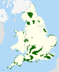 | |
|---|---|---|
| East Midlands | ||
| North East | ||
| North West | ||
| South East | ||
| South West | ||
| West Midlands | ||
| Yorkshire and Humber | ||
Coordinates: 54°08′23″N 1°00′24″W / 54.13974°N 1.00656°W