Garliava
| Garliava | ||
|---|---|---|
| City | ||
| ||
 Garliava Location of Garliava | ||
| Coordinates: 54°49′0″N 23°52′0″E / 54.81667°N 23.86667°ECoordinates: 54°49′0″N 23°52′0″E / 54.81667°N 23.86667°E | ||
| Country |
| |
| Ethnographic region | Suvalkija | |
| County |
| |
| Municipality | Kaunas district municipality | |
| Eldership | Garliava eldership | |
| Capital of |
Garliava eldership Garliava rural eldership | |
| First mentioned | 1809 | |
| Granted city rights | 1958 | |
| Population (2005) | ||
| • Total | 13,423 | |
| Time zone | EET (UTC+2) | |
| • Summer (DST) | EEST (UTC+3) | |

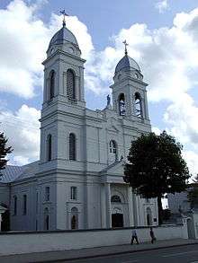
Garliava (![]() pronunciation ), is a city in Lithuania, considered a suburb of Kaunas. Garliava is located 10 km (6.2 mi) south from the center of Kaunas and has a territory of 3,65 km2. In 1809 Józef Godlewski built a Holy Trinity church and named it Godlewo in his own honour, although Lithuanians started calling it Garliava. This year is generally viewed as the year Garliava was founded. It lay along a significant postal route between Saint Petersburg, Kaunas, Marijampolė, and Warsaw.
pronunciation ), is a city in Lithuania, considered a suburb of Kaunas. Garliava is located 10 km (6.2 mi) south from the center of Kaunas and has a territory of 3,65 km2. In 1809 Józef Godlewski built a Holy Trinity church and named it Godlewo in his own honour, although Lithuanians started calling it Garliava. This year is generally viewed as the year Garliava was founded. It lay along a significant postal route between Saint Petersburg, Kaunas, Marijampolė, and Warsaw.
Godlewski also built a place of worship for Lutherans and a synagogue for Jews.
Name
Garliava is the Lithuanian name of the city. Versions of the name in other languages include Polish: Godlewo, Russian: Годлево Godlevo, Belarusian: Гадле́ва Gadleva, Yiddish: גודלעווע Gudleve, Latvian: Garļava.
Notable residents
- Juozas Gabrys (1880 – 1951), politician and advocate of Lithuanian independence, was born in Garliava. In his memoirs, he referred to himself as the "Count of Garliava."
Education
In a relatively small area of 3,65 km2., there are five schools located in this suburb of Kaunas: Garliavos Juozo Lukšos gymnazium, Garliavos Jonučių high school, Garliava high school, Kindergarten and primary school of Garliava and Garliava school of arts and music.
References
- (Lithuanian) History of Garliava. Eldership of Garliava.
External links
- (Polish) Godlewo in the Geographical Dictionary of the Kingdom of Poland (1881)
| Wikimedia Commons has media related to Garliava. |