Gaspé, Quebec
| Gaspé | |
|---|---|
| City | |
| Gaspé | |
 | |
 Location within La Côte-de-Gaspé RCM | |
 Gaspé Location in eastern Quebec | |
| Coordinates: 48°50′N 64°29′W / 48.833°N 64.483°WCoordinates: 48°50′N 64°29′W / 48.833°N 64.483°W[1] | |
| Country |
|
| Province |
|
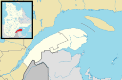
| Region |
Gaspésie– Îles-de-la-Madeleine |
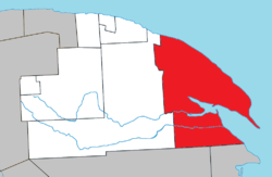
| RCM | La Côte-de-Gaspé |
| Constituted | January 1, 1971 |
| Government[2] | |
| • Mayor | Daniel Côté |
| • Federal riding |
Gaspésie— Îles-de-la-Madeleine |
| • Prov. riding | Gaspé |
| Area[2][3] | |
| • Total | 1,343.40 km2 (518.69 sq mi) |
| • Land | 1,121.07 km2 (432.85 sq mi) |
| Elevation[4] | 34.10 m (111.88 ft) |
| Population (2011)[3] | |
| • Total | 15,163 |
| • Density | 13.5/km2 (35/sq mi) |
| • Pop 2006-2011 |
|
| • Dwellings | 6,897 |
| Time zone | EST (UTC−5) |
| • Summer (DST) | EDT (UTC−4) |
| Postal code(s) | G4X |
| Area code(s) | 418 and 581 |
| Highways |
|
| Website |
www |
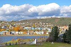
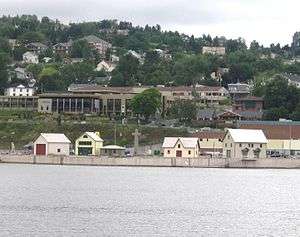
Gaspé is a city at the tip of the Gaspé Peninsula in the Gaspésie–Îles-de-la-Madeleine region of eastern Quebec, Canada. Gaspé is located about 650 kilometres (400 mi) northeast of Quebec City, and 350 kilometres (220 mi) east of Rimouski. As of the Canada 2011 Census, the city had a total population of 15,163.[3]
In addition to Gaspé itself, the city's territory also includes the communities of Cap-aux-Os, Cap-des-Rosiers, Douglastown, Haldimand, Jersey Cove, L'Anse-à-Fugère, L'Anse-à-Valleau, L'Anse-au-Griffon, Penouille, Petit-Cap, Petite-Rivière-au-Renard, Pointe-Jaune, Rivière-au-Renard, Rivière-Morris, Sandy Beach, Saint-Majorique, Saint-Maurice-de-l'Échouerie, Wakeham, and York Centre. The city's territory occupies 1,440 square kilometres (560 sq mi) and borders the sea and the St. Lawrence River for some 130 km (81 mi). French is the first language learnt by most of Gaspé's population where nearly 90% of the population is French Canadian.
Gaspé is where Jacques Cartier took possession of New France (now part of Canada) in the name of François I of France on July 24, 1534.[5]
Etymology
The most common assumption is that "Gaspé" may come from the Mi'kmaq word Gespeg which means "Land's end". However, other theories hold that the name may be a mutation of the Basque word geizpe or kerizpe which means "shelter" or "place of refuge". Another theory is that it is named after Portuguese explorer Gaspar Corte-Real, who explored the Labrador in 1500.[1]
In 1600, Englishman Richard Hakluyt used the name Gaspay in his translation of Cosmosgraphie by Jean Alfonse, which became the common spelling in the early 17th century. Thereafter, many other spellings appeared such as Gachepé, Gachepay, Gaschepay, Gaspey, Gaspèche, and Gapèche.[1]
History
Gaspé claims the title of "Cradle of French America", because on June 24, 1534, Jacques Cartier halted in the bay after losing an anchor during a storm and officially took possession of the area by planting a wooden cross with the king's coat of arms and the sentence Vive le Roi de France (meaning "Long live the King of France"). Cartier met there an indigenous tribe that referred to the territory as Honguedo, probably a Mi'kmaq word meaning "meeting place".[1]
Following the Treaty of Paris in 1763, British officers and soldiers acquired free land in Gaspé. And in 1784, they were joined by many Loyalist settlers. From then on, Gaspé became an important commercial fishing centre, especially of cod. In 1804, its post office opened.[6]
In 1833 in Gaspé County there were only ten farmers, all in the Gaspé Bay area (of whom seven were also involved in the fishery), four whalers in Gaspé Bay, five shipbuilders (one a Jersey firm), one blacksmith, two lumber merchants, five shipowners (all Jerseymen), eighteen fish merchants (of whom all but five were Jerseymen) and thirty-two major fishing establishments (of which sixteen were Jersey owned).
Gaspé was first incorporated as a village municipality in 1855.[1] From 1861 to 1866, the port of Gaspé was a duty-free port, making shipping the primary economic activity. With some 40 to 50 European ships docking annually, many countries opened consulates in Gaspé, including Italy, United States, Brasil, Portugal, and Norway. By 1911, the railroad reached Gaspé. But the town's ambition to become an international shipping and transportation hub ended with the growing importance of the Montreal and Halifax harbours.[6]
During World War II, some 3000 soldiers were stationed at a naval base built at Sandy Beach, in order to patrol the Gulf of Saint Lawrence against German submarines.[6]
In 1959, Gaspé gained city status. In 1971, the city was greatly expanded when it amalgamated these 11 surrounding municipalities (with year of original incorporation):
|
|
In subsequent years, the city's area was further expanded by absorbing large tracts of adjacent unorganized territory.[1]
A representation of a small village, with a dozen houses serving as a historical site, was opened in 2015 in front of the Place Jacques Cartier mall and above the boardwalk along the York River. The village is a monument to Jacques Cartier and serves as a museum for tourists and locals.[7]
Demographics
Population
| Canada census – Gaspé, Quebec community profile | |||
|---|---|---|---|
| 2011 | 2006 | 2001 | |
| Population: | 15,163 (+2.2% from 2006) | 14,834 (-0.7% from 2001) | 14,932 (-9.6% from 1996) |
| Land area: | 1,121.07 km2 (432.85 sq mi) | 1,120.62 km2 (432.67 sq mi) | 1,120.63 km2 (432.68 sq mi) |
| Population density: | 13.5/km2 (35/sq mi) | 13.2/km2 (34/sq mi) | 13.3/km2 (34/sq mi) |
| Median age: | 47.5 (M: 47.0, F: 48.0) | 45.2 (M: 44.7, F: 45.6) | 41.9 (M: 41.4, F: 42.4) |
| Total private dwellings: | 6,897 | 6,428 | 6,280 |
| Median household income: | $52,898 | $44,266 | $39,216 |
| Notes: Includes corrections and updates for 2006. – References: 2011[3] 2006[8] 2001[9] | |||
| Historical Census Data - Gaspé, Quebec[10] | ||||||||||||||||||||||||||
|---|---|---|---|---|---|---|---|---|---|---|---|---|---|---|---|---|---|---|---|---|---|---|---|---|---|---|
|
|
| ||||||||||||||||||||||||
Language
| Canada Census Mother Tongue - Gaspé, Quebec[10] | ||||||||||||||||||
|---|---|---|---|---|---|---|---|---|---|---|---|---|---|---|---|---|---|---|
| Census | Total | French |
English |
French & English |
Other | |||||||||||||
| Year | Responses | Count | Trend | Pop % | Count | Trend | Pop % | Count | Trend | Pop % | Count | Trend | Pop % | |||||
| 2011 |
15,010 |
13,090 | |
87.21% | 1,695 | |
11.29% | 170 | |
1.13% | 55 | |
0.37% | |||||
| 2006 |
14,585 |
12,445 | |
85.33% | 1,885 | |
12.92% | 105 | |
0.72% | 150 | |
1.03% | |||||
| 2001 |
14,670 |
12,710 | |
86.64% | 1,800 | |
12.27% | 115 | |
0.78% | 45 | |
0.31% | |||||
| 1996 |
16,250 |
13,795 | n/a | 84.89% | 2,235 | n/a | 13.75% | 15 | n/a | 0.10% | 205 | n/a | 1.26% | |||||
Cross of Gaspé
In 1934, the Federal Government commissioned the installation of a monolithic granite cross in Gaspé, for the 400th anniversary of the arrival of Jacques Cartier in Gaspé as of July 24, 1534. This 32-foot (9.8 m) high monolithic cross had been cut in 1934, from a block of gray granite extracted from the stone quarry of Augustus Dumas, in Rivière-à-Pierre in the Portneuf region, on North Shore of the Saint Lawrence River. The Cross of Gaspé weighs more than 42 tons and was transported by two railcars of the Canadian National Railway from Rivière-à-Pierre. The cross was carried on a coaster to the Gaspé wharf. The cross was erected on its base using a rail system of pulleys and cables, driven by horses. The original craftsmen would be listed at the top of the cross.[11] This cross is the largest monolithic granite cross crafted in Canada.
A commemorative plaque located at the foot of the Cross in Gaspé was inaugurated on August 23, 2009, in memory of artisans from Rivière-à-Pierre who extracted and cut the block of granite. A replica of the Cross of Gaspé was crafted by Rivière-à-Pierre craftsmen and erected in the heart of the village of Rivière-à-Pierre. That granite cross is half the height of the original cross.
Economy
The regional hospital is the main employer in the city. Another big employer is the factory that makes the windmill blades to then have them transported elsewhere. The windmill factory is a tourist attraction where tourist can see the big size of the blades and have the opportunity to take a picture next to one. Tourism is a very important part of the city and the region's economy. Many visitors come to the city to enjoy the environment and the surrounding attractions, such as Forillon National Park that is fully within the city's boundaries. One of the main summer attractions for tourists is salmon fishing. The York River, Saint John's River, and the Dartmouth River are where tourists and locals alike come to fish. It is not required to have a guide while fishing these rivers but a private guide can be hired upon request. Other tourist attractions include Haldimand Beach, Jacques Cartier's Cross (stone monument), and a local museum which shelters the World War I and World War II cenotaph commemorating Gaspesian veterans.
Transportation
Gaspé is accessible by automobile or Orléans Express bus service via Quebec Route 132, and the Michel-Pouliot Gaspé Airport.
The town is also accessible by Quebec Route 198 that passes through the interior of the peninsula. Select travellers can also access the town during the winter via one of the many snowmobile trails that run through the interior and connect with many other towns on the northern and southern coats of the peninsula. In the summer the same trails are open to all-terrain vehicle travellers as well.
Via Rail's Montreal – Gaspé train was terminated due to unsafe trackage sometime in 2013. The VIA Rail Train to Gaspé was being turned in New Carlisle, 167 kilometres (104 mi) west of Gaspé. VIA was offering bus service between New Carlisle and Gaspé. The line was undergoing repairs since December 2011. At present time VIA has no plans to reinstate service on this line.[12]
The Port of Gaspé has a two-sided wharf; on the one, it measures 175 metres (574 ft), with a depth of 8 metres (26 ft), and on the other measures 180 metres (590 ft) with a depth of 10 metres (33 ft). The Port of Gaspé is accessible year-round with the occasional help of an icebreaker.[13]
Its near neighbour Chandler is a port of call for Le Vacancier, a ferry which links Montréal to the Îles-de-la-Madeleine.[14]
Climate
In spite of its coastal position, Gaspé experiences a humid continental climate (Köppen climate classification Dfb) with vast seasonal differences in temperature. Summers are warm but relatively short, whereas winters are very cold given its coastal position, but still far warmer than inland areas of the province. It stays above the subarctic range due to the seasonal lag keeping September temperatures above 10 °C (50 °F) in daily mean. As a result of the seasonal lag, March is a proper winter month and is far colder than November. As typical of Quebec, precipitation and resulting snowfall is high due to the reliable winter temperatures below freezing.
The highest temperature ever recorded in Gaspé was 36.0 °C (96.8 °F) on 27 June 2003.[4] The coldest temperature ever recorded was −43 °F (−41.7 °C) on 26 January 1897.[15]
| Climate data for Gaspé Airport, 1981–2010 normals, extremes 1895–present[lower-alpha 1] | |||||||||||||
|---|---|---|---|---|---|---|---|---|---|---|---|---|---|
| Month | Jan | Feb | Mar | Apr | May | Jun | Jul | Aug | Sep | Oct | Nov | Dec | Year |
| Record high °C (°F) | 14.4 (57.9) |
13.7 (56.7) |
21.1 (70) |
27.5 (81.5) |
31.8 (89.2) |
36.0 (96.8) |
34.8 (94.6) |
35.0 (95) |
33.2 (91.8) |
29.4 (84.9) |
22.2 (72) |
15.6 (60.1) |
36.0 (96.8) |
| Average high °C (°F) | −5.9 (21.4) |
−4.6 (23.7) |
0.4 (32.7) |
6.4 (43.5) |
14.0 (57.2) |
19.8 (67.6) |
23.2 (73.8) |
22.6 (72.7) |
17.9 (64.2) |
10.8 (51.4) |
4.0 (39.2) |
−2.3 (27.9) |
8.9 (48) |
| Daily mean °C (°F) | −11.6 (11.1) |
−10.6 (12.9) |
−5.3 (22.5) |
1.5 (34.7) |
7.7 (45.9) |
13.1 (55.6) |
16.8 (62.2) |
16.1 (61) |
11.6 (52.9) |
5.6 (42.1) |
−0.2 (31.6) |
−6.9 (19.6) |
3.1 (37.6) |
| Average low °C (°F) | −17.3 (0.9) |
−16.5 (2.3) |
−10.8 (12.6) |
−3.3 (26.1) |
1.3 (34.3) |
6.3 (43.3) |
10.4 (50.7) |
9.5 (49.1) |
5.2 (41.4) |
0.3 (32.5) |
−4.4 (24.1) |
−11.4 (11.5) |
−2.6 (27.3) |
| Record low °C (°F) | −41.7 (−43.1) |
−38.9 (−38) |
−32.8 (−27) |
−20.6 (−5.1) |
−11.7 (10.9) |
−3.9 (25) |
−1.1 (30) |
0.0 (32) |
−6.7 (19.9) |
−12.2 (10) |
−23.3 (−9.9) |
−32.2 (−26) |
−41.7 (−43.1) |
| Average precipitation mm (inches) | 87.5 (3.445) |
65.1 (2.563) |
98.4 (3.874) |
90.0 (3.543) |
89.2 (3.512) |
79.6 (3.134) |
100.3 (3.949) |
93.7 (3.689) |
81.6 (3.213) |
121.3 (4.776) |
111.4 (4.386) |
116.9 (4.602) |
1,135.1 (44.689) |
| Average rainfall mm (inches) | 16.2 (0.638) |
7.8 (0.307) |
27.3 (1.075) |
50.2 (1.976) |
84.1 (3.311) |
79.6 (3.134) |
100.3 (3.949) |
93.7 (3.689) |
81.6 (3.213) |
116.1 (4.571) |
75.8 (2.984) |
46.5 (1.831) |
779.2 (30.677) |
| Average snowfall cm (inches) | 80.2 (31.57) |
63.2 (24.88) |
71.8 (28.27) |
36.8 (14.49) |
4.6 (1.81) |
0.0 (0) |
0.0 (0) |
0.0 (0) |
0.0 (0) |
4.0 (1.57) |
36.2 (14.25) |
75.0 (29.53) |
371.8 (146.38) |
| Average precipitation days (≥ 0.2 mm) | 14.8 | 12.1 | 13.9 | 13.0 | 13.9 | 13.0 | 15.4 | 12.9 | 11.9 | 14.6 | 14.6 | 16.2 | 166.3 |
| Average rainy days (≥ 0.2 mm) | 2.3 | 2.0 | 4.0 | 8.8 | 13.7 | 13.0 | 15.4 | 12.9 | 11.9 | 14.1 | 8.9 | 4.5 | 111.4 |
| Average snowy days (≥ 0.2 cm) | 13.7 | 11.4 | 11.7 | 6.7 | 1.3 | 0.0 | 0.0 | 0.0 | 0.0 | 1.5 | 8.0 | 14.3 | 68.5 |
| Average relative humidity (%) (at 1500 LST) | 65.3 | 62.6 | 62.1 | 61.0 | 58.0 | 59.3 | 63.4 | 62.0 | 62.7 | 64.9 | 70.0 | 71.5 | 63.6 |
| Mean monthly sunshine hours | 106.4 | 128.6 | 154.0 | 162.5 | 211.7 | 236.7 | 251.3 | 231.8 | 176.8 | 131.5 | 90.1 | 88.5 | 1,970.1 |
| Percent possible sunshine | 39.2 | 44.3 | 41.8 | 39.6 | 44.8 | 49.2 | 51.6 | 52.1 | 46.7 | 39.1 | 34.5 | 34.6 | 43.0 |
| Source: Environment Canada[4][15][16][17] | |||||||||||||
International relationships
Gaspé is twinned with:
-
 Puerto Montt, Chile (2005)
 -
 Saint-Malo, France (2009)
See also
References
- 1 2 3 4 5 6 "Gaspé (ville)" (in French). Commission de toponymie du Québec. Retrieved 2011-12-02.
- 1 2 "Gaspé". Répertoire des municipalités (in French). Ministère des Affaires municipales, des Régions et de l'Occupation du territoire. Retrieved 2011-12-02.
- 1 2 3 4 "Gaspé census profile". 2011 Census data. Statistics Canada. Retrieved 2011-12-02.
- 1 2 3 "Gaspé A". Canadian Climate Normals 1981–2010. Environment Canada. Retrieved 27 July 2016.
- ↑ Allaire, Bernard. "Jacques Cartier". Retrieved 2016-07-18.
- 1 2 3 "À propos de Gaspé" (in French). Ville de Gaspé. Retrieved 2011-12-05.
- ↑ "Project history - Site historique Gaspé, Berceau du Canada". Retrieved 2016-07-18.
- ↑ "2006 Community Profiles". Canada 2006 Census. Statistics Canada. March 30, 2011. Retrieved 2011-12-02.
- ↑ "2001 Community Profiles". Canada 2001 Census. Statistics Canada. February 17, 2012. Retrieved 2011-12-02.
- 1 2 Statistics Canada: 1996, 2001, 2006, 2011 census
- ↑ Journal Le Soleil, August 22, 2009, journalist Johanne Martin, article "Croix de Gaspé: des origines reconnues"("Cross of Gaspé: origins recognized"), describing the unveiling of August 23, 2009 a commemorative plaque located at the foot of the cross of Gaspé, in memory of the craftsmen who made the cross in 1934. (French)
- ↑ "Gaspésie : le retour du train de passagers incertain". radio-canada. 4 March 2015. Retrieved 20 November 2016.
- ↑ qsl.com: "PORT DE GASPÉTerminal SANDY BEACH" accessed Aug 2014
- ↑ gouv.qc.ca: "Traverses et dessertes maritimes du Quebec"
- 1 2 "Daily Data Report for January 1897". Canadian Climate Data. Environment Canada. Retrieved 27 July 2016.
- ↑ "Gaspé". Canadian Climate Data. Environment Canada. Retrieved 27 July 2016.
- ↑ "Daily Data Report for March 2012". Canadian Climate Data. Environment Canada. Retrieved 27 July 2016.
Notes
- ↑ Extreme high and low temperatures in the table below were recorded at Gaspé from August 1895 to April 1968 and at Gaspé Airport from May 1968 to present.
External links
| Wikimedia Commons has media related to Gaspé. |
 |
Honguedo Strait | | ||
| Rivière-Saint-Jean | |
Gulf of Saint Lawrence | ||
| ||||
| | ||||
| Mont-Alexandre | Percé |
| Cities | |
|---|---|
| Municipalities | |
| Townships | |
| Unorganized Territories | |
| |