Generals Highway
| Generals Highway | |
|---|---|
|
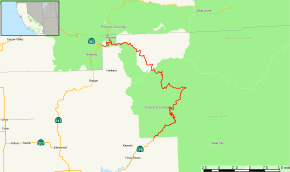
Map of Tulare County in central California with Generals Highway highlighted in red | |
| Route information | |
| Length: | 32.5 mi (52.3 km) |
| Major junctions | |
| South end: |
|
| North end: |
|
| Location | |
| Counties: | Tulare |
| Highway system | |
.jpg)
The Generals Highway is a highway that connects State Route 180 and State Route 198 through Sequoia National Park, Giant Sequoia National Monument, and Kings Canyon National Park in the Sierra Nevada of California.[1]
Route description
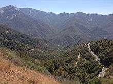
It is named after two of the largest and most famous Giant Sequoia trees, the General Sherman and General Grant trees. The highway is notoriously steep, narrow, winding, and difficult to drive, especially its southern section from Hospital Rock to Giant Forest within Sequoia National Park. This section also consists of numerous switchbacks, and has a speed limit of 10 MPH. Regulations restrict the length of vehicles—they must not exceed 40 feet (12 m), although vehicles longer than 22 feet (6.7 m) are not recommended to use the road [2] between Potwisha Campground and Giant Forest Museum.[3]
The highway begins at a southern intersection with SR 198. The road travels northeast along the middle fork of the Kaweah River and enters Sequoia National Park through the Indian Head Entrance. Near the Hospital Rock turnout, the road turns north and goes through several turns before straightening out and continuing northeast, passing near the General Sherman Tree. At Lodgepole Bridge, the road turns west before later turning north. Generals Highway leaves Sequoia National Park through the North Entrance, entering Sequoia National Forest.[4] The road continues northwest through Giant Sequoia National Monument before traveling along the northern border of Kings Canyon National Park, briefly entering it before terminating at SR 180.[5]
History
Two of the stone bridges on the highway are listed on the National Register of Historic Places.[6]
Major intersections
The entire route is in Tulare County.
| Location | mi | km | Destinations | Notes | |
|---|---|---|---|---|---|
| | 0.00 | 0.00 | |||
| | 32.5 | 52.3 | |||
| 1.000 mi = 1.609 km; 1.000 km = 0.621 mi | |||||
References
- ↑ NPS: History of the Generals Highway
- ↑ http://www.nps.gov/seki/
- ↑ "Vehicles and Traffic Safety" (PDF). National Park Service. Retrieved 2010-01-16.
- ↑
- ↑ California Road Atlas (Map). Thomas Brothers. 2008.
- ↑ "National Register of Historic Places Inventory - Nomination Form" (PDF). National Park Service. Retrieved 2010-01-16.
External links
| Wikimedia Commons has media related to Generals Highway. |